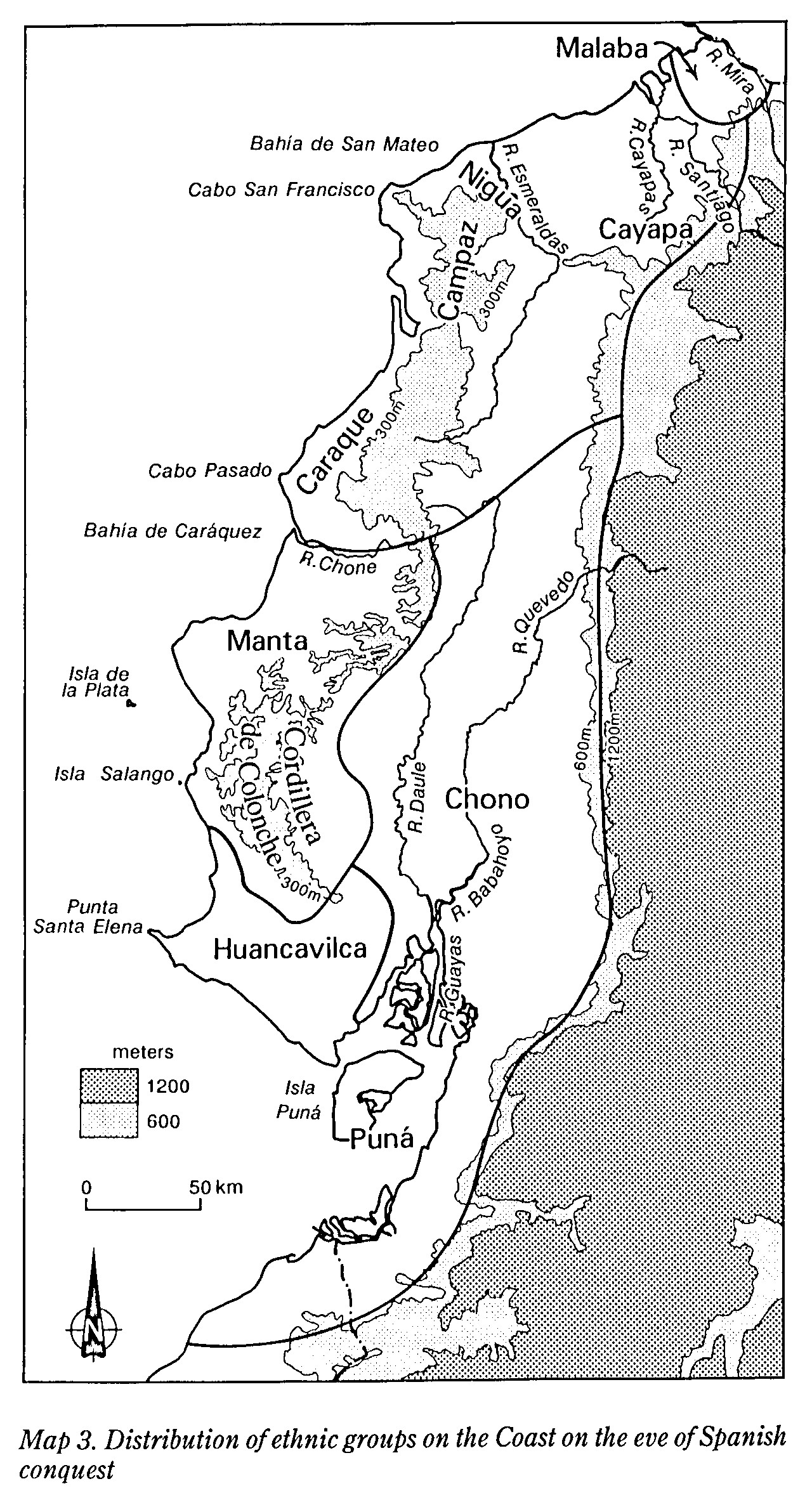
Dispossesions in the Americas

Dispossesions in the Americas

  • Home
  • Explore
  • About
  • Authors
  • Art
  • Bodies
  • Curricula
  • Cultural Heritage
  • Maps
  • Territories
Back to Explore
Map 1490

MAP 3. DISTRIBUTION OF ETHNIC GROUPS OF THE COAST ON THE EVE OF SPANISH CONQUEST

  • LINDA A. NEWSON

Published: 1995

  • Download Image

Peoples

  • MALABA
  • CAYAPA
  • NIGUA
  • CAMPAZ
  • CARANQUI
  • MANTENO
  • MILAGRO-QUEVEDO
  • PUNA

Citation

Newson;Linda A. Life and Death In Early Colonial Ecuador. Norman: University of Oklahoma Press;1995. https://franklin.library.upenn.edu/catalog/FRANKLIN_9918959033503681

  • Download Image

Reading in Spanish

Map 1490

MAP 3. DISTRIBUTION OF ETHNIC GROUPS OF THE COAST ON THE EVE OF SPANISH CONQUEST

  • LINDA A. NEWSON

Published: 1995

  • Download Image
  • Download Image

Reading in Portuguese

Map 1490

MAP 3. DISTRIBUTION OF ETHNIC GROUPS OF THE COAST ON THE EVE OF SPANISH CONQUEST

  • LINDA A. NEWSON

Published: 1995

  • Download Image

Peoples

  • MALABA
  • CAYAPA
  • NIGUA
  • CAMPAZ
  • CARANQUI
  • MANTENO
  • MILAGRO-QUEVEDO
  • PUNA

Citation

Newson;Linda A. Life and Death In Early Colonial Ecuador. Norman: University of Oklahoma Press;1995. https://franklin.library.upenn.edu/catalog/FRANKLIN_9918959033503681

  • Download Image

Related Content

Geographic Distribution of Huichol and Cora, Showing Towns and Elevations

Geographic Distribution of Huichol and Cora, Showing Towns and Elevations

Map 1969
Ubicación histórica de los ópatas

Ubicación histórica de los ópatas

Map 1959
VICEROYALTY OF NEW GRANADA AND GOVERNMENT OF CARACAS

VICEROYALTY OF NEW GRANADA AND GOVERNMENT OF CARACAS

Map 1813
La France. Amérique Française (Guyane). Afrique Française (Illes S.te Marie, Nossi-bé, Nossi-cumba, Nossi-fali &.).

La France. Amérique Française (Guyane). Afrique Française (Illes S.te Marie, Nossi-bé, Nossi-cumba, Nossi-fali &.).

Map 1869
ANGAITÉ

ANGAITÉ

Map 2015
GEOGRAPHISCHE KARTE DER PROVINZ VON SÃO JOZÉ DO PIAUHY. Carte Géographique de PIAUHY, Province de l'Empire du Brésil

GEOGRAPHISCHE KARTE DER PROVINZ VON SÃO JOZÉ DO PIAUHY. Carte Géographique de PIAUHY, Province de l'Empire du Brésil

Map 1828
PRESENT-DAY MAYA LANGUAGE BOUNDARIES OF GUATEMALA

PRESENT-DAY MAYA LANGUAGE BOUNDARIES OF GUATEMALA

Map 1961
"Territorio Indígena Cabécar de Ujarrás"

"Territorio Indígena Cabécar de Ujarrás"

Map 2010

Dispossessions in the Americas

A project by

University of Pennsylvania

Copyright 2024

With support from

Mellon Foundation

Site design & development

Element 84

Art Credits

Newson;Linda A. Life and Death In Early Colonial Ecuador. Norman: University of Oklahoma Press;1995. https://franklin.library.upenn.edu/catalog/FRANKLIN_9918959033503681

Site Pages

  • Home
  • Explore
  • About
  • Authors
  • Art
  • Bodies
  • Curricula
  • Cultural Heritage
  • Maps
  • Territories