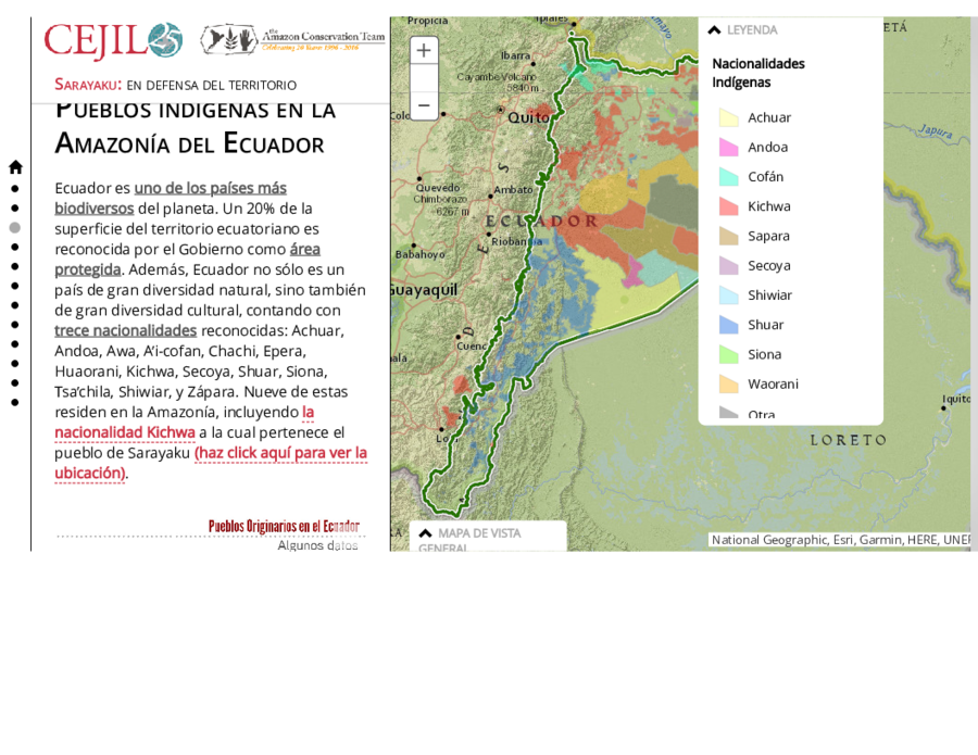
Dispossesions in the Americas

Dispossesions in the Americas

  • Home
  • Explore
  • About
  • Authors
  • Art
  • Bodies
  • Curricula
  • Cultural Heritage
  • Maps
  • Territories
Back to Explore
Map 2021

Pueblos indígenas en la Amazonía del Ecuador

  • RAISG

Published: 2021

  • Download Image

Peoples

  • ACHUAR
  • ANDOA
  • AI' COFAN
  • KICHWA
  • SAPARA
  • SECOYA
  • SHIWIAR
  • SHUAR
  • SIONA
  • WAORANI

Citation

Centro por la Justicia y el Derecho Internacional. "Sarayaku: en defensa del territorio." Amazon Conservation Team. Accessed AUGUST 16;2021. https://www.amazonteam.org/maps/sarayaku-es/.

  • Download Image

Reading in Spanish

Map 2021

Pueblos indígenas en la Amazonía del Ecuador

  • RAISG

Published: 2021

  • Download Image
  • Download Image

Reading in Portuguese

Map 2021

Pueblos indígenas en la Amazonía del Ecuador

  • RAISG

Published: 2021

  • Download Image

Peoples

  • ACHUAR
  • ANDOA
  • AI' COFAN
  • KICHWA
  • SAPARA
  • SECOYA
  • SHIWIAR
  • SHUAR
  • SIONA
  • WAORANI

Citation

Centro por la Justicia y el Derecho Internacional. "Sarayaku: en defensa del territorio." Amazon Conservation Team. Accessed AUGUST 16;2021. https://www.amazonteam.org/maps/sarayaku-es/.

  • Download Image

Related Content

GUERRERO

GUERRERO

Map 2015
Radicación de Comunidades Mapuche. Titulos de Comisario y Titulos de Merced

Radicación de Comunidades Mapuche. Titulos de Comisario y Titulos de Merced

Map 1884 - 1929
PUEBLOS INDIGENAS

PUEBLOS INDIGENAS

Map 2021
CARACCAS AND GUIANA

CARACCAS AND GUIANA

Map 1814
PRINCIPALES GRUPOS ÉTNICOS DEL TERRITORIO ESEQUIBO

PRINCIPALES GRUPOS ÉTNICOS DEL TERRITORIO ESEQUIBO

Map 1979
Sketch of the country from reduction to Buenos Ayres, shewing the movements of B. Genl. Beresford, when he captured that place June 1806. Drawn from memorandums furnished by Capt: Donnelly

Sketch of the country from reduction to Buenos Ayres, shewing the movements of B. Genl. Beresford, when he captured that place June 1806. Drawn from memorandums furnished by Capt: Donnelly

Map 1806
The Spanish and Musketor shore and the bay of Honduras and the islands adjacent

The Spanish and Musketor shore and the bay of Honduras and the islands adjacent

Map 1735
Mapa de la Isla de Cuba y tierras circunvecinas según la división de los naturales con las derrotas que siguió el Almirante Cristóbal Colón para servir de ilustración a su historia antigua

Mapa de la Isla de Cuba y tierras circunvecinas según la división de los naturales con las derrotas que siguió el Almirante Cristóbal Colón para servir de ilustración a su historia antigua

Map 1500 - 1599

Dispossessions in the Americas

A project by

University of Pennsylvania

Copyright 2024

With support from

Mellon Foundation

Site design & development

Element 84

Art Credits

Centro por la Justicia y el Derecho Internacional. “Sarayaku: en defensa del territorio.” Amazon Conservation Team. Accessed AUGUST 16;2021. https://www.amazonteam.org/maps/sarayaku-es/.

Site Pages

  • Home
  • Explore
  • About
  • Authors
  • Art
  • Bodies
  • Curricula
  • Cultural Heritage
  • Maps
  • Territories