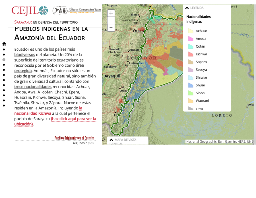
Dispossesions in the Americas

Dispossesions in the Americas

  • Home
  • Explore
  • About
  • Authors
  • Art
  • Bodies
  • Curricula
  • Cultural Heritage
  • Maps
  • Territories
Back to Explore
Map 2021

Pueblos indígenas en la Amazonía del Ecuador

  • RAISG

Published: 2021

  • Download Image

Peoples

  • ACHUAR
  • ANDOA
  • AI' COFAN
  • KICHWA
  • SAPARA
  • SECOYA
  • SHIWIAR
  • SHUAR
  • SIONA
  • WAORANI

Citation

Centro por la Justicia y el Derecho Internacional. "Sarayaku: en defensa del territorio." Amazon Conservation Team. Accessed AUGUST 16;2021. https://www.amazonteam.org/maps/sarayaku-es/.

  • Download Image

Reading in Spanish

Map 2021

Pueblos indígenas en la Amazonía del Ecuador

  • RAISG

Published: 2021

  • Download Image
  • Download Image

Reading in Portuguese

Map 2021

Pueblos indígenas en la Amazonía del Ecuador

  • RAISG

Published: 2021

  • Download Image

Peoples

  • ACHUAR
  • ANDOA
  • AI' COFAN
  • KICHWA
  • SAPARA
  • SECOYA
  • SHIWIAR
  • SHUAR
  • SIONA
  • WAORANI

Citation

Centro por la Justicia y el Derecho Internacional. "Sarayaku: en defensa del territorio." Amazon Conservation Team. Accessed AUGUST 16;2021. https://www.amazonteam.org/maps/sarayaku-es/.

  • Download Image

Related Content

A Gente Rio /We River

A Gente Rio /We River

Artwork
INDIGENOUS DRAFT LABOR (MITA) FOR MINES OF POTOSI UNDER SPANISH COLONIAL RULE – THE CASE OF THE PAKAXA AYMARA POLITY IN THE LATE 16TH CENTURY

INDIGENOUS DRAFT LABOR (MITA) FOR MINES OF POTOSI UNDER SPANISH COLONIAL RULE – THE CASE OF THE PAKAXA AYMARA POLITY IN THE LATE 16TH CENTURY

Map 1570 - 1650
[Partie de l'Oyapock]

[Partie de l'Oyapock]

Map 1700 - 1799
The Southern Maya Lowlands during the Sixteenth and Seventeenth Centuries

The Southern Maya Lowlands during the Sixteenth and Seventeenth Centuries

Map 1500 - 1700
Pescaria [Fishing]

Pescaria [Fishing]

Artwork
Distribution of Nahuatl Population, Mexico

Distribution of Nahuatl Population, Mexico

Map 1969
Fig. 1 Map of the Guianas with schematic locations of the
indigenous groups relevant to our study, based on the linguistic
map of South America (http://www.muturzikin.com/cartesamerique/
7.htm). Carib-speaking groups are indicated in yellow, Arawak-speaking
groups in blue, Tupi-speaking Wayãpi in pink and the Warao-speaking
group in green

Fig. 1 Map of the Guianas with schematic locations of the indigenous groups relevant to our study, based on the linguistic map of South America (http://www.muturzikin.com/cartesamerique/ 7.htm). Carib-speaking groups are indicated in yellow, Arawak-speaking groups in blue, Tupi-speaking Wayãpi in pink and the Warao-speaking group in green

Map 2000 - 2024
PUEBLO YAMINAHUA

PUEBLO YAMINAHUA

Map 2021

Dispossessions in the Americas

A project by

University of Pennsylvania

Copyright 2024

With support from

Mellon Foundation

Site design & development

Element 84

Art Credits

Centro por la Justicia y el Derecho Internacional. “Sarayaku: en defensa del territorio.” Amazon Conservation Team. Accessed AUGUST 16;2021. https://www.amazonteam.org/maps/sarayaku-es/.

Site Pages

  • Home
  • Explore
  • About
  • Authors
  • Art
  • Bodies
  • Curricula
  • Cultural Heritage
  • Maps
  • Territories