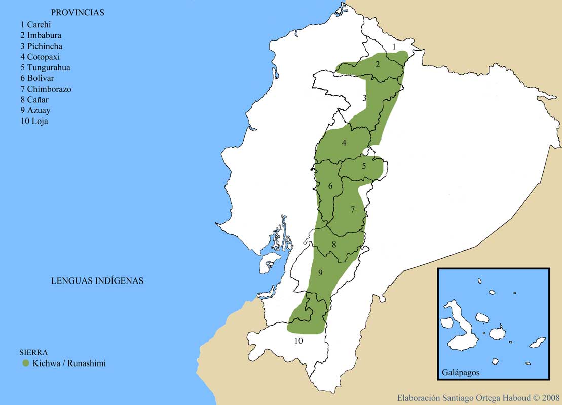
Dispossesions in the Americas

Dispossesions in the Americas

  • Home
  • Explore
  • About
  • Authors
  • Art
  • Bodies
  • Curricula
  • Cultural Heritage
  • Maps
  • Territories
Back to Explore
Map 2008

LENGUAS INDIGENAS SIERRA

  • SANTIAGO ORTEGA HABOUD

Published: 2008

  • Download Image

Peoples

  • KARANKI
  • NATABUELA
  • OTAVALO
  • KAYAMBI
  • KITU-KARA
  • PANZALEO
  • CHIBULEO
  • SARAGURO
  • KANARI
  • SALASAKA
  • PURUHA

Citation

Ortega Haboud;Santiago. "Nacionalidades Indígenas de la Sierra." Map. Oralidad Modernidad. 2008. Accessed August 4;2021. https://www.puce.edu.ec/oralidadmodernidad/sierra.php

  • Download Image

Reading in Spanish

Map 2008

LENGUAS INDIGENAS SIERRA

  • SANTIAGO ORTEGA HABOUD

Published: 2008

  • Download Image
  • Download Image

Reading in Portuguese

Map 2008

LENGUAS INDIGENAS SIERRA

  • SANTIAGO ORTEGA HABOUD

Published: 2008

  • Download Image

Peoples

  • KARANKI
  • NATABUELA
  • OTAVALO
  • KAYAMBI
  • KITU-KARA
  • PANZALEO
  • CHIBULEO
  • SARAGURO
  • KANARI
  • SALASAKA
  • PURUHA

Citation

Ortega Haboud;Santiago. "Nacionalidades Indígenas de la Sierra." Map. Oralidad Modernidad. 2008. Accessed August 4;2021. https://www.puce.edu.ec/oralidadmodernidad/sierra.php

  • Download Image

Related Content

El descubrimiento del Amazonas [The Discovery of the Amazon]

El descubrimiento del Amazonas [The Discovery of the Amazon]

Artwork
LOCALIZACIÓN DE LOS PRINCIPALES ASENTAMIENTOS TICUNAS

LOCALIZACIÓN DE LOS PRINCIPALES ASENTAMIENTOS TICUNAS

Map 2000
REPÚBLICA BOLIVARIANA DE VENEZUELA PUEBLOS Y COMUNIDADES INDÍGENAS

REPÚBLICA BOLIVARIANA DE VENEZUELA PUEBLOS Y COMUNIDADES INDÍGENAS

Map 2004
Quechan settlements, circa 1770-1900

Quechan settlements, circa 1770-1900

Map 1770 - 1900
Serie Fatherland / Padre Patria

Serie Fatherland / Padre Patria

Artwork
PROVINCIA DE MINAS GERAES

PROVINCIA DE MINAS GERAES

Map 1873
RESGUARDO DE TUKUNARE

RESGUARDO DE TUKUNARE

Map 2012
The Spanish and Musketor shore and the bay of Honduras and the islands adjacent

The Spanish and Musketor shore and the bay of Honduras and the islands adjacent

Map 1735

Dispossessions in the Americas

A project by

University of Pennsylvania

Copyright 2024

With support from

Mellon Foundation

Site design & development

Element 84

Art Credits

Ortega Haboud;Santiago. “Nacionalidades Indígenas de la Sierra.” Map. Oralidad Modernidad. 2008. Accessed August 4;2021. https://www.puce.edu.ec/oralidadmodernidad/sierra.php

Site Pages

  • Home
  • Explore
  • About
  • Authors
  • Art
  • Bodies
  • Curricula
  • Cultural Heritage
  • Maps
  • Territories