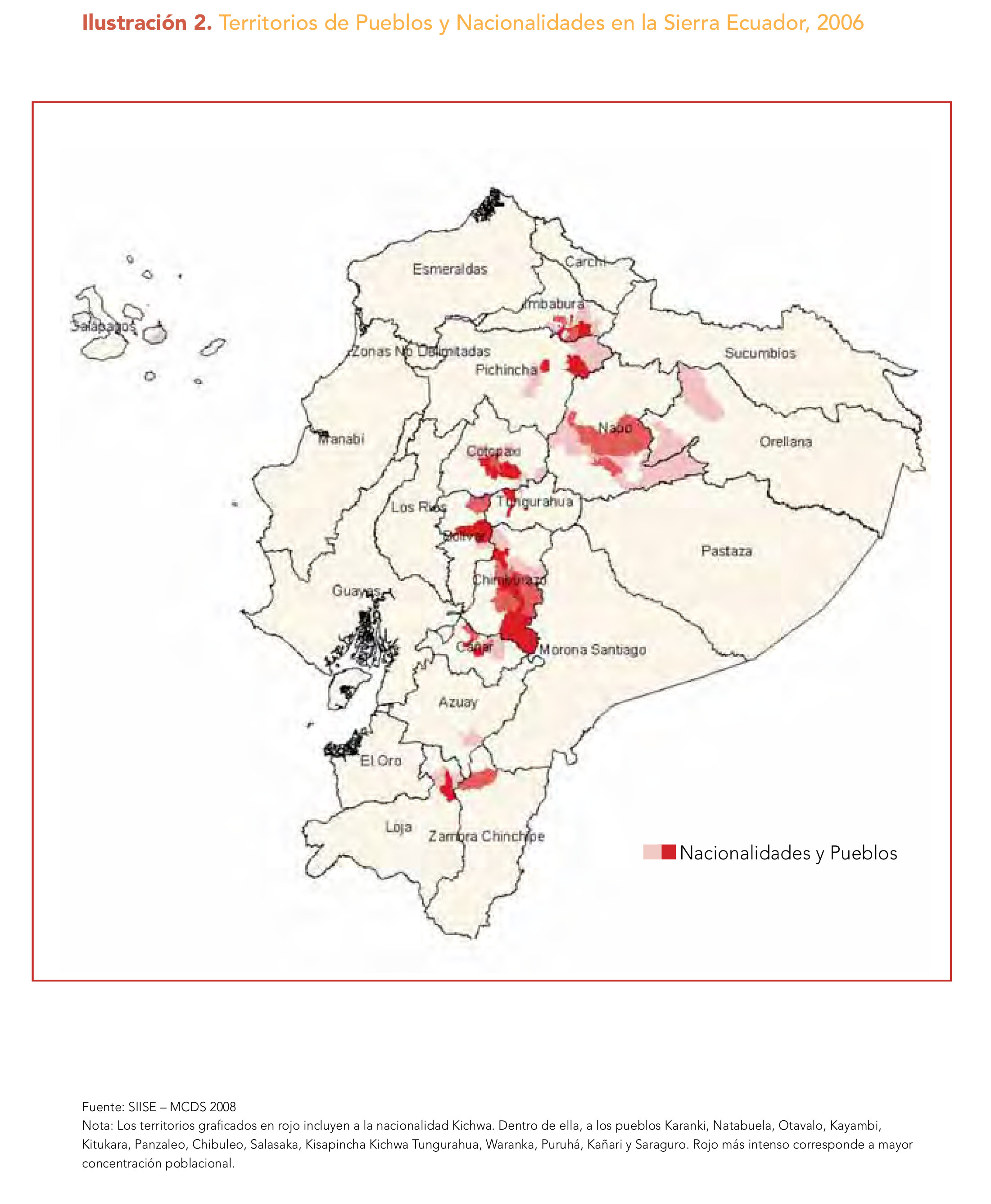
Dispossesions in the Americas

Dispossesions in the Americas

  • Home
  • Explore
  • About
  • Authors
  • Art
  • Bodies
  • Curricula
  • Cultural Heritage
  • Maps
  • Territories
Back to Explore
Map 2006

Ilustración 2. Territorios de Pueblos y Nacionalidades en la Sierra Ecuador;2006

  • SIISE – MCDS 2008

Published: 2008

  • Download Image

Peoples

  • KICHWA
  • KARANKI
  • NATABUELA
  • OTAVALO
  • KAYAMBI
  • KITUKARA
  • PANZALEO
  • PURUHA
  • KANARI
  • SARAGURO

Citation

MINISTERIO COORDINADOR DE PATRIMONIO. “Nacionalidades y Pueblos Indígenas;y Políticas Interculturales En Ecuador: Una Mirada Desde La Educación.” MDG Fund. MINISTERIO COORDINADOR DE PATRIMONIO;2008. http://www.mdgfund.org/sites/default/files/nacionalidades_y_pueblos_indigenas_web(1).pdf.

  • Download Image

Reading in Spanish

Map 2006

Ilustración 2. Territorios de Pueblos y Nacionalidades en la Sierra Ecuador;2006

  • SIISE – MCDS 2008

Published: 2008

  • Download Image
  • Download Image

Reading in Portuguese

Map 2006

Ilustración 2. Territorios de Pueblos y Nacionalidades en la Sierra Ecuador;2006

  • SIISE – MCDS 2008

Published: 2008

  • Download Image

Peoples

  • KICHWA
  • KARANKI
  • NATABUELA
  • OTAVALO
  • KAYAMBI
  • KITUKARA
  • PANZALEO
  • PURUHA
  • KANARI
  • SARAGURO

Citation

MINISTERIO COORDINADOR DE PATRIMONIO. “Nacionalidades y Pueblos Indígenas;y Políticas Interculturales En Ecuador: Una Mirada Desde La Educación.” MDG Fund. MINISTERIO COORDINADOR DE PATRIMONIO;2008. http://www.mdgfund.org/sites/default/files/nacionalidades_y_pueblos_indigenas_web(1).pdf.

  • Download Image

Related Content

Serie Historia de la peruvian corporaishion [History of the Peruvian Corporaishion Series]

Serie Historia de la peruvian corporaishion [History of the Peruvian Corporaishion Series]

Artwork
Map of the basin of La Plata : based upon the results of the expedition under the command of Thos. J. Page;U.S. Navy;in the years 1853;-'54;-'55;& 56 and of the adjacent countries

Map of the basin of La Plata : based upon the results of the expedition under the command of Thos. J. Page;U.S. Navy;in the years 1853;-'54;-'55;& 56 and of the adjacent countries

Map 1853 - 1856
Reducción del territorio Barí 1500-1900

Reducción del territorio Barí 1500-1900

Map 1500 - 1900
Mapa del territorio que misionaban los franciscanos al norte de Charcas y oriente de los Andes

Mapa del territorio que misionaban los franciscanos al norte de Charcas y oriente de los Andes

Map 1678
Retrato de Lourdes [Portrait of Lourdes]

Retrato de Lourdes [Portrait of Lourdes]

Artwork
CANTON de PIACOA de la PROVINCIA DE GUAYANA

CANTON de PIACOA de la PROVINCIA DE GUAYANA

Map 1840
Ogiva

Ogiva

Artwork
Mapa de las tierras indígenas - Pueblos

Mapa de las tierras indígenas - Pueblos

Map 2017

Dispossessions in the Americas

A project by

University of Pennsylvania

Copyright 2024

With support from

Mellon Foundation

Site design & development

Element 84

Art Credits

MINISTERIO COORDINADOR DE PATRIMONIO. “Nacionalidades y Pueblos Indígenas;y Políticas Interculturales En Ecuador: Una Mirada Desde La Educación.” MDG Fund. MINISTERIO COORDINADOR DE PATRIMONIO;2008. http://www.mdgfund.org/sites/default/files/nacionalidades_y_pueblos_indigenas_web(1).pdf.

Site Pages

  • Home
  • Explore
  • About
  • Authors
  • Art
  • Bodies
  • Curricula
  • Cultural Heritage
  • Maps
  • Territories