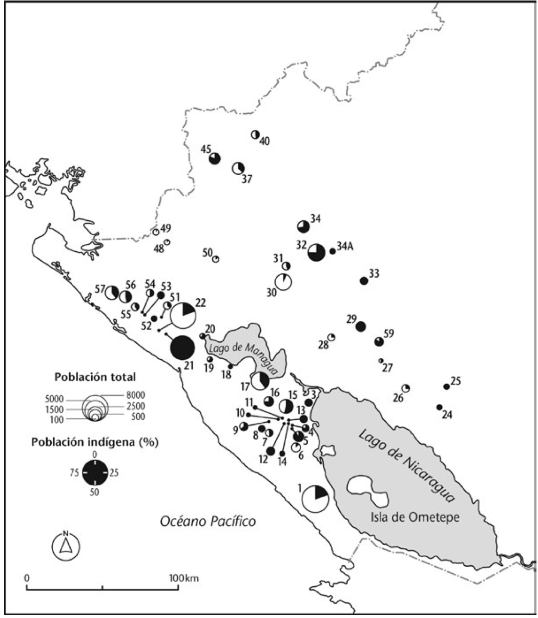
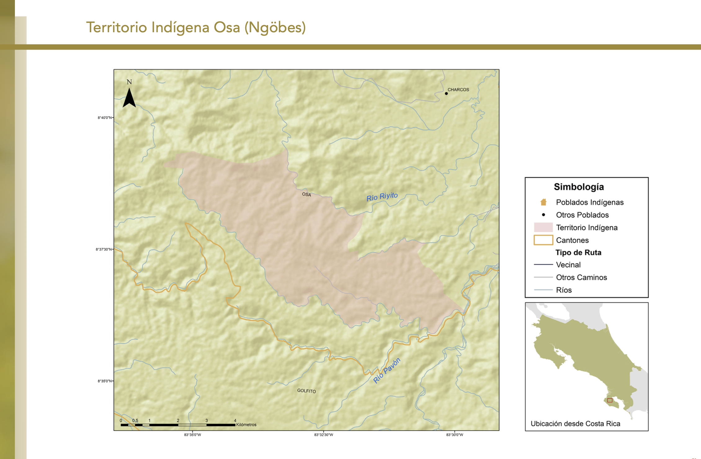
Dispossesions in the Americas

Dispossesions in the Americas

  • Home
  • Explore
  • About
  • Authors
  • Art
  • Bodies
  • Curricula
  • Cultural Heritage
  • Maps
  • Territories
Back to Explore
Map 2010

"Territorio Indígena Osa (Ngöbes)"

  • GÓMEZ ET AL.

Published: 2014

  • Download Image

Peoples

  • NGOBES

Citation

Gómez Meléndez, Agustín, Felipe González Evora, Heiddys García, Marco      Espinoza, and Fabián Solano Monge. Atlas de territorios      indígenas--Universidad de Costa Rica. Costa Rica: Universidad de Costa      Rica, 2014.         https://hdl.handle.net/10669/15110

  • Download Image

Reading in Spanish

Map 2010

"Territorio Indígena Osa (Ngöbes)"

  • GÓMEZ ET AL.

Published: 2014

  • Download Image
  • Download Image

Reading in Portuguese

Map 2010

"Territorio Indígena Osa (Ngöbes)"

  • GÓMEZ ET AL.

Published: 2014

  • Download Image

Peoples

  • NGOBES

Citation

Gómez Meléndez, Agustín, Felipe González Evora, Heiddys García, Marco      Espinoza, and Fabián Solano Monge. Atlas de territorios      indígenas--Universidad de Costa Rica. Costa Rica: Universidad de Costa      Rica, 2014.         https://hdl.handle.net/10669/15110

  • Download Image

Related Content

PUEBLO HUAVE

PUEBLO HUAVE

Map 2020
Distribución Territorial Actual del Pueblo Kawesqar. XII Region de Magallanes y la Antártica Chile

Distribución Territorial Actual del Pueblo Kawesqar. XII Region de Magallanes y la Antártica Chile

Map 1993
MAP 7.—The Highland tribes of Colombia and Ecuador. (Drawn from data compiled by Gregorio Hernández de Alba;John Murra;Sergio Elías Ortíz;and Henri Lehmann.)

MAP 7.—The Highland tribes of Colombia and Ecuador. (Drawn from data compiled by Gregorio Hernández de Alba;John Murra;Sergio Elías Ortíz;and Henri Lehmann.)

Map 1400
Índia [India]

Índia [India]

Artwork
Mapa de la población total y porcentaje de indios;1776

Mapa de la población total y porcentaje de indios;1776

Map 1776
APPROXIMATE BORDERS OF TERRITORY OF THE AYMARA POLITY KARANQAS (OR CARANGAS) IN THE 19TH CENTURY

APPROXIMATE BORDERS OF TERRITORY OF THE AYMARA POLITY KARANQAS (OR CARANGAS) IN THE 19TH CENTURY

Map 1894
PUEBLO NAHUA DE DURANGO

PUEBLO NAHUA DE DURANGO

Map 2020
LOCALIZACIÓN GEOGRÁFICA DE BORAS Y MIRAÑAS

LOCALIZACIÓN GEOGRÁFICA DE BORAS Y MIRAÑAS

Map

Dispossessions in the Americas

A project by

University of Pennsylvania

Copyright 2024

With support from

Mellon Foundation

Site design & development

Element 84

Art Credits

Gómez Meléndez, Agustín, Felipe González Evora, Heiddys García, Marco      Espinoza, and Fabián Solano Monge. Atlas de territorios      indígenas–Universidad de Costa Rica. Costa Rica: Universidad de Costa      Rica, 2014.         https://hdl.handle.net/10669/15110

Site Pages

  • Home
  • Explore
  • About
  • Authors
  • Art
  • Bodies
  • Curricula
  • Cultural Heritage
  • Maps
  • Territories