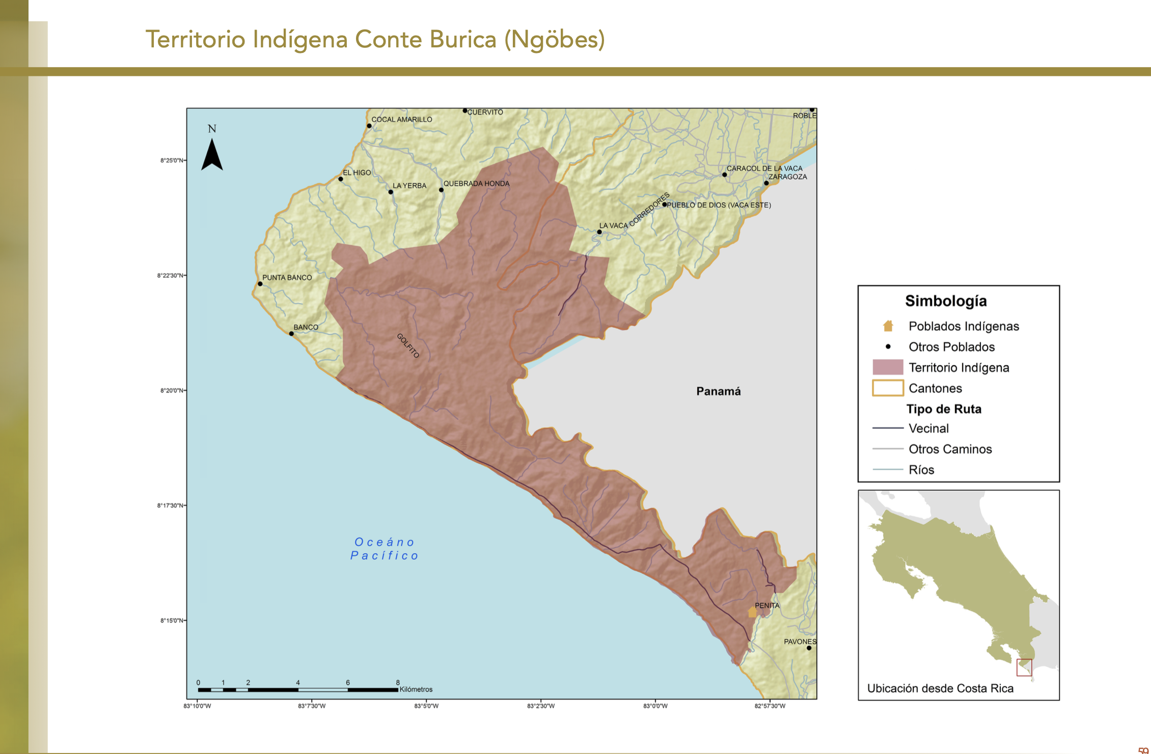
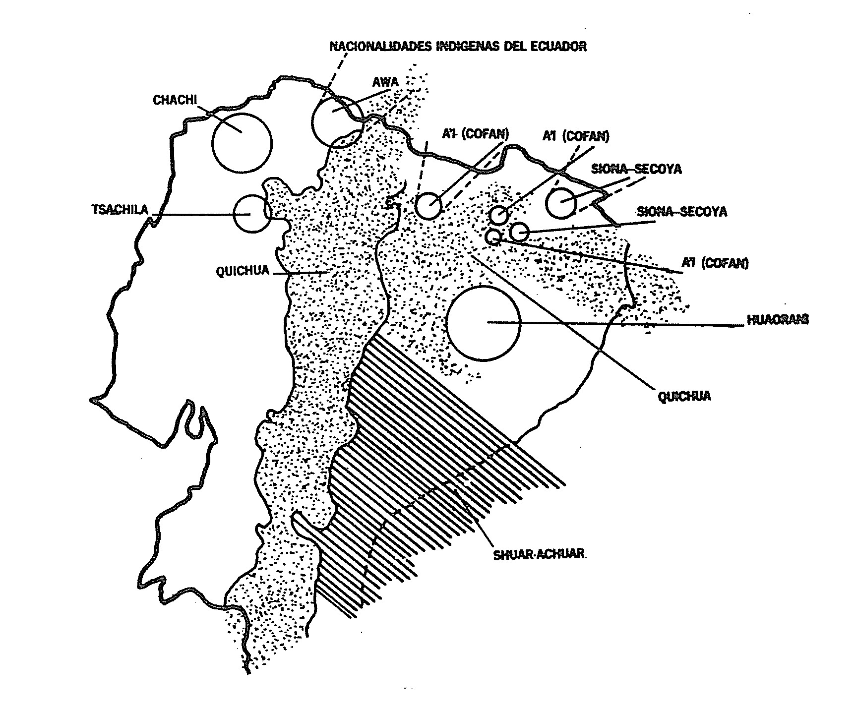
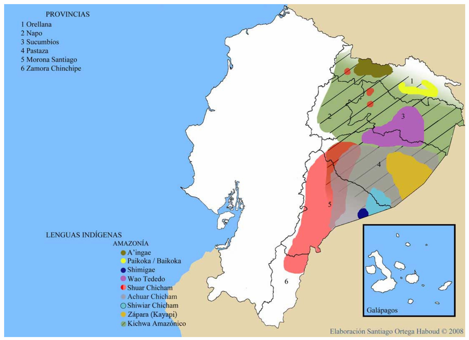
Dispossesions in the Americas

Dispossesions in the Americas

  • Home
  • Explore
  • About
  • Authors
  • Art
  • Bodies
  • Curricula
  • Cultural Heritage
  • Maps
  • Territories
Back to Explore
Map 2010

"Territorio Indígena Conte Burica (Ngöbes)

  • GÓMEZ ET AL.

Published: 2014

  • Download Image

Peoples

  • NGOBES

Citation

Gómez Meléndez, Agustín, Felipe González Evora, Heiddys García, Marco      Espinoza, and Fabián Solano Monge. Atlas de territorios      indígenas--Universidad de Costa Rica. Costa Rica: Universidad de Costa      Rica, 2014.         https://hdl.handle.net/10669/15109

  • Download Image

Reading in Spanish

Map 2010

"Territorio Indígena Conte Burica (Ngöbes)

  • GÓMEZ ET AL.

Published: 2014

  • Download Image
  • Download Image

Related Content

Plan de la côte de la Guyane depuis la Riviere de Mahury jusqu'à celle de Macouria comprenant la rade de Cayenne Levé géométriquement en 1764 et 1765.

Plan de la côte de la Guyane depuis la Riviere de Mahury jusqu'à celle de Macouria comprenant la rade de Cayenne Levé géométriquement en 1764 et 1765.

Map 1764 - 1765
PRIMERAS CULTURAS QUITENAS - LA AMAZONIA - GENEALOGÍA - INVASIONES MAYAS

PRIMERAS CULTURAS QUITENAS - LA AMAZONIA - GENEALOGÍA - INVASIONES MAYAS

Map
Otoxha

Otoxha

Map 1997
Mapa del territorio que misionaban los franciscanos al norte de Charcas y oriente de los Andes

Mapa del territorio que misionaban los franciscanos al norte de Charcas y oriente de los Andes

Map 1678
Croquis de la Laguna de Nicaragua

Croquis de la Laguna de Nicaragua

Map 1784
ALIMENTOS TRADICIONALES DE LOS PUEBLOS INDÍGENAS DE PARAGUAY

ALIMENTOS TRADICIONALES DE LOS PUEBLOS INDÍGENAS DE PARAGUAY

Map
Peruviae Auriferae Regionis Typus. Didaco Mendezio auctore (with) La Florida. Auctore Hieron. Chiaves. Cum Privilegio. (with) Guastecan.

Peruviae Auriferae Regionis Typus. Didaco Mendezio auctore (with) La Florida. Auctore Hieron. Chiaves. Cum Privilegio. (with) Guastecan.

Map 1608
A Map of part of Yucatan or of that Part of the Eastern Shore Within the Bay of Honduras Alloted to Great Britain for the Cutting of Logwood, in consequence of the Convention Signed with Spain on the 14th July 1786.

A Map of part of Yucatan or of that Part of the Eastern Shore Within the Bay of Honduras Alloted to Great Britain for the Cutting of Logwood, in consequence of the Convention Signed with Spain on the 14th July 1786.

Map 1700

Dispossessions in the Americas

A project by

University of Pennsylvania

Copyright 2024

With support from

Mellon Foundation

Site design & development

Element 84

Art Credits

Gómez Meléndez, Agustín, Felipe González Evora, Heiddys García, Marco      Espinoza, and Fabián Solano Monge. Atlas de territorios      indígenas–Universidad de Costa Rica. Costa Rica: Universidad de Costa      Rica, 2014.         https://hdl.handle.net/10669/15109

Site Pages

  • Home
  • Explore
  • About
  • Authors
  • Art
  • Bodies
  • Curricula
  • Cultural Heritage
  • Maps
  • Territories