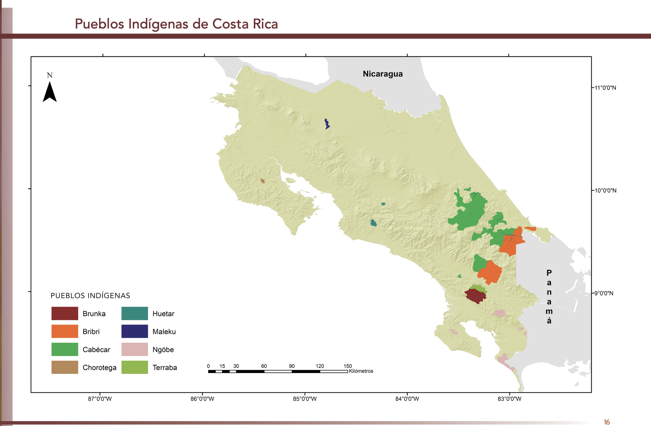
Dispossesions in the Americas

Dispossesions in the Americas

  • Home
  • Explore
  • About
  • Authors
  • Art
  • Bodies
  • Curricula
  • Cultural Heritage
  • Maps
  • Territories
Back to Explore
Map 2010

"Pueblos Indígenas de Costa Rica"

  • GÓMEZ ET AL.

Published: 2014

  • Download Image

Peoples

  • BRUNKA
  • BRIBRI
  • CABECAR
  • CHOROTEGA
  • HUETAR
  • MALEKU
  • NGOBE
  • TERRABA

Citation

Gómez Meléndez, Agustín, Felipe González Evora, Heiddys García, Marco      Espinoza, and Fabián Solano Monge. Atlas de territorios      indígenas--Universidad de Costa Rica. Costa Rica: Universidad de Costa      Rica, 2014.         https://hdl.handle.net/10669/15090

  • Download Image

Reading in Spanish

Map 2010

"Pueblos Indígenas de Costa Rica"

  • GÓMEZ ET AL.

Published: 2014

  • Download Image
  • Download Image

Reading in Portuguese

Map 2010

"Pueblos Indígenas de Costa Rica"

  • GÓMEZ ET AL.

Published: 2014

  • Download Image

Peoples

  • BRUNKA
  • BRIBRI
  • CABECAR
  • CHOROTEGA
  • HUETAR
  • MALEKU
  • NGOBE
  • TERRABA

Citation

Gómez Meléndez, Agustín, Felipe González Evora, Heiddys García, Marco      Espinoza, and Fabián Solano Monge. Atlas de territorios      indígenas--Universidad de Costa Rica. Costa Rica: Universidad de Costa      Rica, 2014.         https://hdl.handle.net/10669/15090

  • Download Image

Related Content

Map of the Ucayali River

Map of the Ucayali River

Map 1808 - 1812
Carte des environs de Cap de Nord

Carte des environs de Cap de Nord

Map 1774
Tierra [Earth]

Tierra [Earth]

Artwork
Lamento Guaraní [Guaraní Lament]

Lamento Guaraní [Guaraní Lament]

Artwork
Carte du Gouvernement de Cayenne dans l'Amérique Méridionale

Carte du Gouvernement de Cayenne dans l'Amérique Méridionale

Map 1763
PUEBLO Q'ANJOB'AL

PUEBLO Q'ANJOB'AL

Map 2020
Tribes of the Gran Chaco: Locations at the first European contact

Tribes of the Gran Chaco: Locations at the first European contact

Map 1524
Carte Du Bresil. Prem. Partie ;Depuis la Riviere des Amazones jusquà la Baye de Tous les Sants;Pour servir à l'Histoire Générale des Voyages

Carte Du Bresil. Prem. Partie ;Depuis la Riviere des Amazones jusquà la Baye de Tous les Sants;Pour servir à l'Histoire Générale des Voyages

Map 1700 - 1750

Dispossessions in the Americas

A project by

University of Pennsylvania

Copyright 2024

With support from

Mellon Foundation

Site design & development

Element 84

Art Credits

Gómez Meléndez, Agustín, Felipe González Evora, Heiddys García, Marco      Espinoza, and Fabián Solano Monge. Atlas de territorios      indígenas–Universidad de Costa Rica. Costa Rica: Universidad de Costa      Rica, 2014.         https://hdl.handle.net/10669/15090

Site Pages

  • Home
  • Explore
  • About
  • Authors
  • Art
  • Bodies
  • Curricula
  • Cultural Heritage
  • Maps
  • Territories