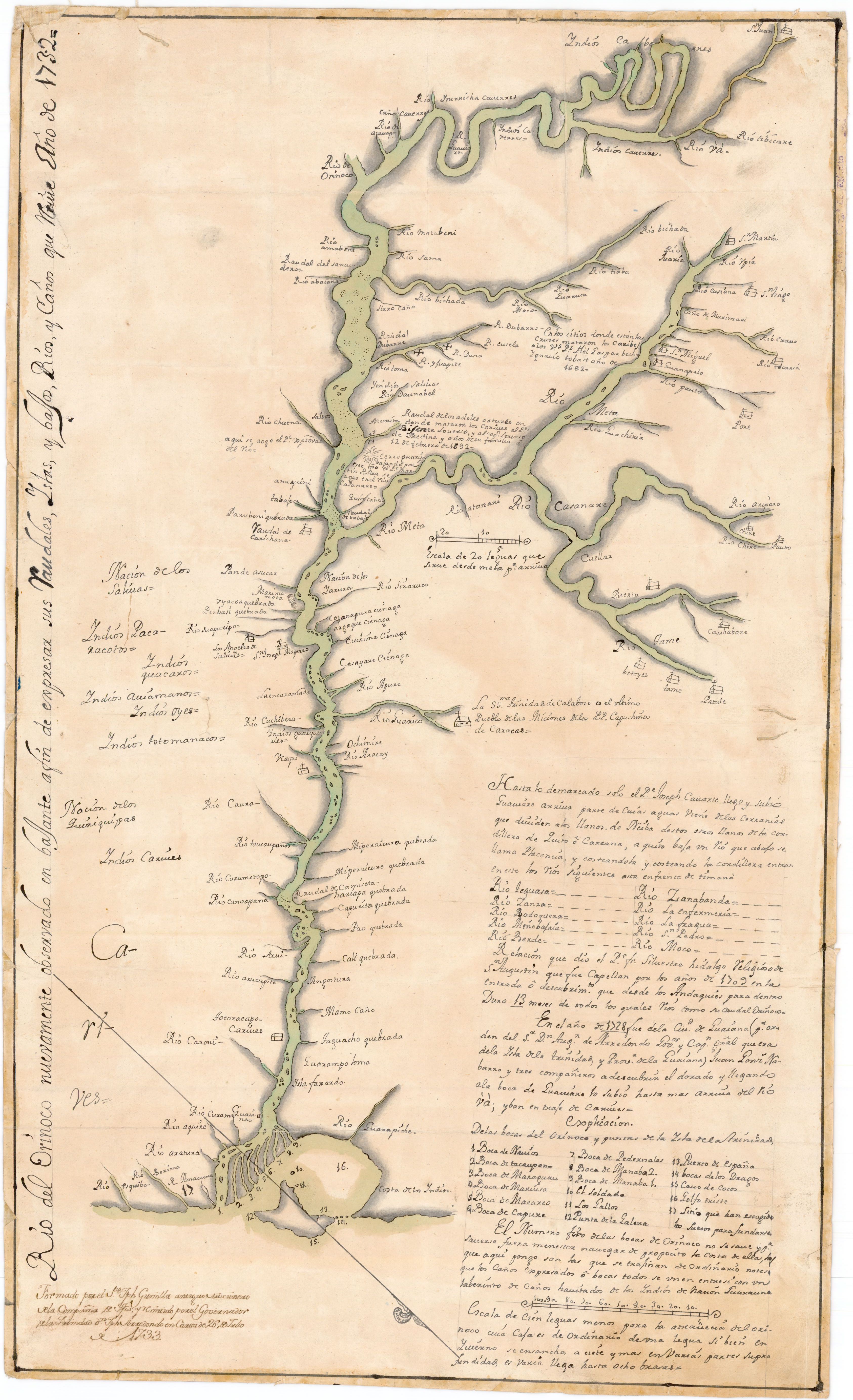
Dispossesions in the Americas

Dispossesions in the Americas

  • Home
  • Explore
  • About
  • Authors
  • Art
  • Bodies
  • Curricula
  • Cultural Heritage
  • Maps
  • Territories
Back to Explore
Map 1761

Plan del Puerto de Bahiahonda, Provincia del Rio del Hacha, Auitado su terreno de varias naciones de Yndios Guagiros

  • GUZMÁN Y ZAFREÑO, GREGORIO

Published: 1761

  • Download Image

Peoples

  • GUAGIROS

Citation

GUZMÁN Y ZAFREÑO, GREGORIO. Plan del Puerto de Bahiahonda, Provincia del Rio del Hacha, Auitado su terreno de varias naciones de Yndios Guagiros. ES.41091.AGI//MP-PANAMA,159. Portal de Archivos Españoles - PARES. 1761, Accessed, October 27, 2023. http://pares.mcu.es/ParesBusquedas20/catalogo/show/22207

  • Download Image

Reading in Spanish

Map 1761

Plan del Puerto de Bahiahonda, Provincia del Rio del Hacha, Auitado su terreno de varias naciones de Yndios Guagiros

  • GUZMÁN Y ZAFREÑO, GREGORIO

Published: 1761

  • Download Image
  • Download Image

Related Content

South America corrected from the observation communicated to the
     Royal Society"s of London & Paris by John Senex, at the Globe against St.
     Dunstans Church Fleetstreet.

South America corrected from the observation communicated to the Royal Society"s of London & Paris by John Senex, at the Globe against St. Dunstans Church Fleetstreet.

Map 1755
MBYÁ GUARANÍ

MBYÁ GUARANÍ

Map 2015
Fig. 1 Map of the Guianas with schematic locations of the
indigenous groups relevant to our study, based on the linguistic
map of South America (http://www.muturzikin.com/cartesamerique/
7.htm). Carib-speaking groups are indicated in yellow, Arawak-speaking
groups in blue, Tupi-speaking Wayãpi in pink and the Warao-speaking
group in green

Fig. 1 Map of the Guianas with schematic locations of the indigenous groups relevant to our study, based on the linguistic map of South America (http://www.muturzikin.com/cartesamerique/ 7.htm). Carib-speaking groups are indicated in yellow, Arawak-speaking groups in blue, Tupi-speaking Wayãpi in pink and the Warao-speaking group in green

Map 2000 - 2024
FAMILIAS LINGUÍSTICAS Y LENGUAS INDÍGENAS. CUARTA REGIÓN: AMAZONIA SEPTENTRIONAL

FAMILIAS LINGUÍSTICAS Y LENGUAS INDÍGENAS. CUARTA REGIÓN: AMAZONIA SEPTENTRIONAL

Map 1989
PART OF A CHART OF THE NORTHERN COAST OF SOUTH AMERICA BY THOMAS JEFFERYS

PART OF A CHART OF THE NORTHERN COAST OF SOUTH AMERICA BY THOMAS JEFFERYS

Map 1792
PUEBLO POPOLUCA DE LA SIERRA

PUEBLO POPOLUCA DE LA SIERRA

Map 2020
Chinantec Municipios, 1950

Chinantec Municipios, 1950

Map 1950
Côtes du continent d'Amérique despuis le cap Ste Marthe...jusqu'au cap Cameron.

Côtes du continent d'Amérique despuis le cap Ste Marthe...jusqu'au cap Cameron.

Map 1784

Dispossessions in the Americas

A project by

University of Pennsylvania

Copyright 2024

With support from

Mellon Foundation

Site design & development

Element 84

Art Credits

GUZMÁN Y ZAFREÑO, GREGORIO. Plan del Puerto de Bahiahonda, Provincia del Rio del Hacha, Auitado su terreno de varias naciones de Yndios Guagiros. ES.41091.AGI//MP-PANAMA,159. Portal de Archivos Españoles - PARES. 1761, Accessed, October 27, 2023. http://pares.mcu.es/ParesBusquedas20/catalogo/show/22207

Site Pages

  • Home
  • Explore
  • About
  • Authors
  • Art
  • Bodies
  • Curricula
  • Cultural Heritage
  • Maps
  • Territories