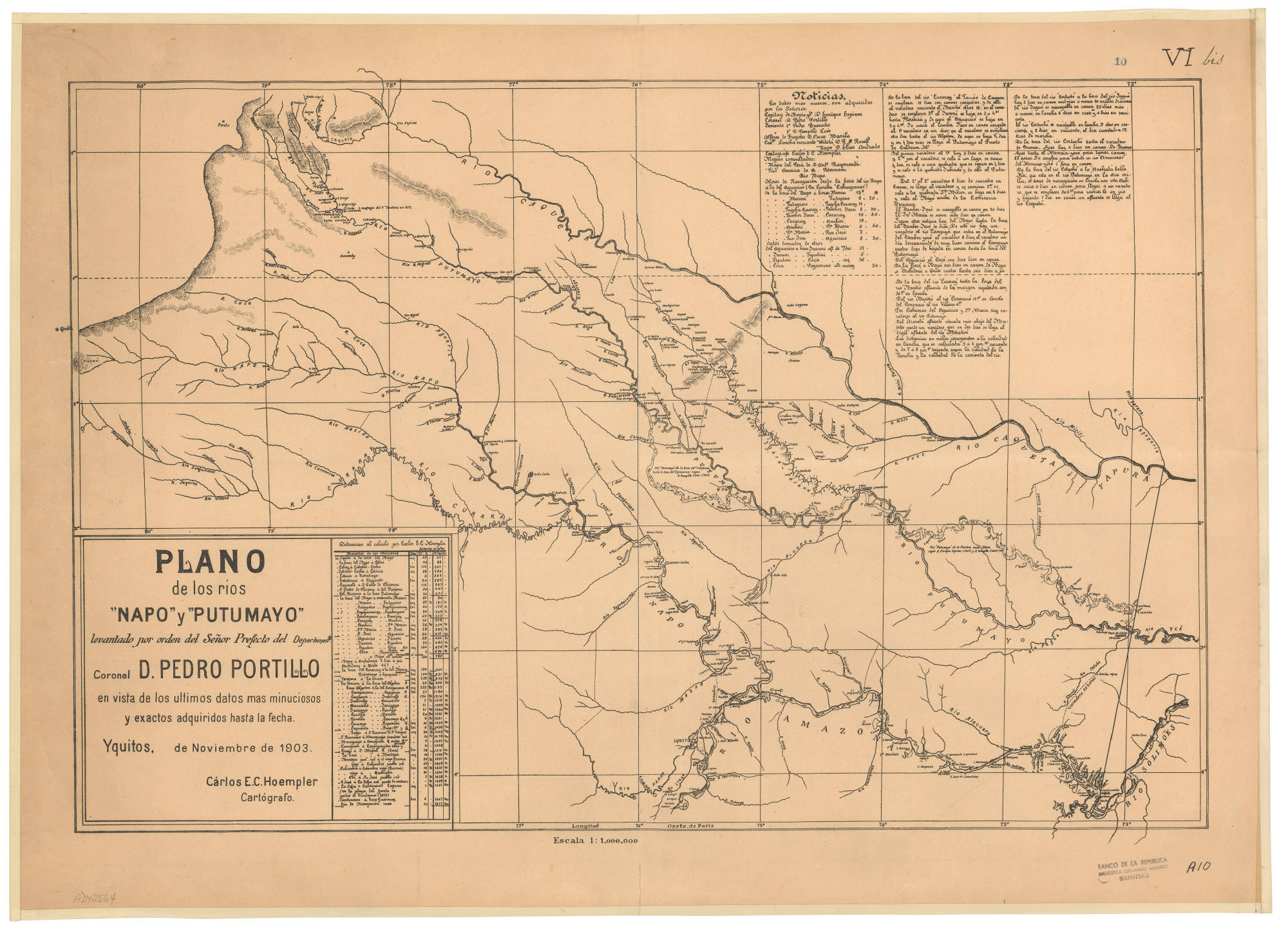
Dispossesions in the Americas

Dispossesions in the Americas

  • Home
  • Explore
  • About
  • Authors
  • Art
  • Bodies
  • Curricula
  • Cultural Heritage
  • Maps
  • Territories
Back to Explore
Map 1903

PLANO de los rios “NAPO” y “PUTUMAYO” levantado por orden del Señor Prefecto del Departamento Coronel D. PEDRO PORTILLO

  • HOEMPLER, CARLOS E.C.

Published: 1903

  • Download Image

Peoples

  • OMAGUAS
  • JEVEROS
  • OCAINAS
  • URONAS
  • MEREYES
  • CARGONAS
  • ANDOQUES
  • MONUYAS
  • MUINANES

Citation

Hoempler, C. E. C. Plano de los ríos Napo y Putumayo levantado por orden del señor prefecto del departamento, Coronel D. Pedro Portillo [Map]. Red de Bibliotecas del Banco de la República en Colombia. 1903 https://babel.banrepcultural.org/digital/collection/p17054coll13/id/315/rec/10

  • Download Image

Reading in Spanish

Map 1903

PLANO de los rios “NAPO” y “PUTUMAYO” levantado por orden del Señor Prefecto del Departamento Coronel D. PEDRO PORTILLO

  • HOEMPLER, CARLOS E.C.

Published: 1903

  • Download Image
  • Download Image

Reading in Portuguese

Map 1903

PLANO de los rios “NAPO” y “PUTUMAYO” levantado por orden del Señor Prefecto del Departamento Coronel D. PEDRO PORTILLO

  • HOEMPLER, CARLOS E.C.

Published: 1903

  • Download Image

Peoples

  • OMAGUAS
  • JEVEROS
  • OCAINAS
  • URONAS
  • MEREYES
  • CARGONAS
  • ANDOQUES
  • MONUYAS
  • MUINANES

Citation

Hoempler, C. E. C. Plano de los ríos Napo y Putumayo levantado por orden del señor prefecto del departamento, Coronel D. Pedro Portillo [Map]. Red de Bibliotecas del Banco de la República en Colombia. 1903 https://babel.banrepcultural.org/digital/collection/p17054coll13/id/315/rec/10

  • Download Image

Related Content

CONCENTRACIÓN DE POBLACION DE TRES Y MAS ANOS QUE HABLAN LENGUA INDÍGENA EN MÉRIDA, YUCATÁN, 2010

CONCENTRACIÓN DE POBLACION DE TRES Y MAS ANOS QUE HABLAN LENGUA INDÍGENA EN MÉRIDA, YUCATÁN, 2010

Map 2012
Los a'i como área cultural chibcha

Los a'i como área cultural chibcha

Map 1997
SOUTH AMERICA SHEET III. SOUTH BRAZIL WITH PARAGUAY AND URUGUAY

SOUTH AMERICA SHEET III. SOUTH BRAZIL WITH PARAGUAY AND URUGUAY

Map 1837
Las Misiones en América del Sur

Las Misiones en América del Sur

Map 1609 - 1832
Kowkülen [Liquid being]

Kowkülen [Liquid being]

Artwork
Die landtschafft mit den genanten hauingen so ich zum teyl in America gesehen hab...

Die landtschafft mit den genanten hauingen so ich zum teyl in America gesehen hab...

Map 1500 - 1550
Retrato de Lourdes [Portrait of Lourdes]

Retrato de Lourdes [Portrait of Lourdes]

Artwork
Pátria, sangue e nada mais [Homeland, Blood and Nothing More]

Pátria, sangue e nada mais [Homeland, Blood and Nothing More]

Artwork

Dispossessions in the Americas

A project by

University of Pennsylvania

Copyright 2024

With support from

Mellon Foundation

Site design & development

Element 84

Art Credits

Hoempler, C. E. C. Plano de los ríos Napo y Putumayo levantado por orden del señor prefecto del departamento, Coronel D. Pedro Portillo [Map]. Red de Bibliotecas del Banco de la República en Colombia. 1903 https://babel.banrepcultural.org/digital/collection/p17054coll13/id/315/rec/10

Site Pages

  • Home
  • Explore
  • About
  • Authors
  • Art
  • Bodies
  • Curricula
  • Cultural Heritage
  • Maps
  • Territories