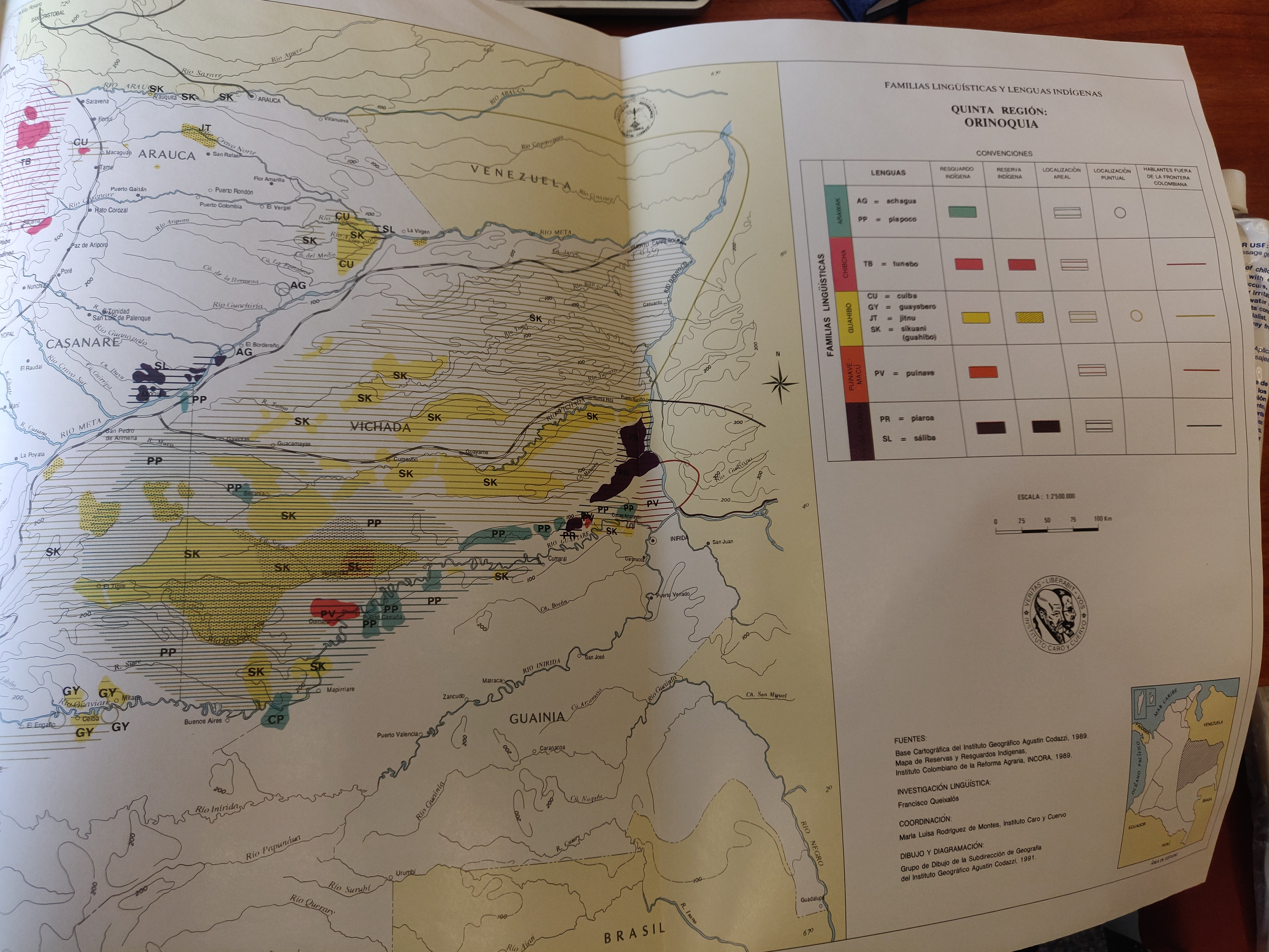
Dispossesions in the Americas

Dispossesions in the Americas

  • Home
  • Explore
  • About
  • Authors
  • Art
  • Bodies
  • Curricula
  • Cultural Heritage
  • Maps
  • Territories
Back to Explore
Map 1989

FAMILIAS LINGUISTICAS Y LENGUAS INDÍGENAS. QUINTA REGION: ORINOQUIA.

  • INSTITUTO GEOGRAFICO AGUSTIN CODAZZI/INCORA

Published: 1991

  • Download Image

Peoples

  • ACHAGUA
  • CUIBA
  • GUAYABERO
  • JITNU
  • PIAPOCO
  • PIAROS
  • PUINAVE
  • SALIBA
  • SIKUANI (GUAHIBO)
  • TUNEBO

Citation

Maria Stella Gonzalez de Perez y Maria Luisa Rodriguez de Montes (2000), "Lenguas Indigenas de Colombia," Instituto Caro y Cuervo, Bogota. 1989 (Localización geográfica de Boras y Mirañas, p. 566)

  • Download Image

Reading in Spanish

Map 1989

FAMILIAS LINGUISTICAS Y LENGUAS INDÍGENAS. QUINTA REGION: ORINOQUIA.

  • INSTITUTO GEOGRAFICO AGUSTIN CODAZZI/INCORA

Published: 1991

  • Download Image
  • Download Image

Reading in Portuguese

Map 1989

FAMILIAS LINGUISTICAS Y LENGUAS INDÍGENAS. QUINTA REGION: ORINOQUIA.

  • INSTITUTO GEOGRAFICO AGUSTIN CODAZZI/INCORA

Published: 1991

  • Download Image

Peoples

  • ACHAGUA
  • CUIBA
  • GUAYABERO
  • JITNU
  • PIAPOCO
  • PIAROS
  • PUINAVE
  • SALIBA
  • SIKUANI (GUAHIBO)
  • TUNEBO

Citation

Maria Stella Gonzalez de Perez y Maria Luisa Rodriguez de Montes (2000), "Lenguas Indigenas de Colombia," Instituto Caro y Cuervo, Bogota. 1989 (Localización geográfica de Boras y Mirañas, p. 566)

  • Download Image

Related Content

Main Native Groups in Eastern Oaxaca

Main Native Groups in Eastern Oaxaca

Map 1969
Indiens des Guyanes

Indiens des Guyanes

Map 1894
Mapa de la Governacion del Paraguay y de la de Buenos Ayres con la linea divisoria de las tierras de España y Portugal ajustada entre las dos Coronas año 1750 cuya posesion se pretende tomar este año de 1752

Mapa de la Governacion del Paraguay y de la de Buenos Ayres con la linea divisoria de las tierras de España y Portugal ajustada entre las dos Coronas año 1750 cuya posesion se pretende tomar este año de 1752

Map 1752
Geographic Distribution of Huichol and Cora, Showing State Names

Geographic Distribution of Huichol and Cora, Showing State Names

Map 1969
Distribución étnica en el siglo XVI

Distribución étnica en el siglo XVI

Map 1500 - 1599
PARTIE MERIDIONALE DU PEROU

PARTIE MERIDIONALE DU PEROU

Map 1749
Territorio ópata

Territorio ópata

Map 2015
Gulf of Amapall

Gulf of Amapall

Map 1683 - 1685

Dispossessions in the Americas

A project by

University of Pennsylvania

Copyright 2024

With support from

Mellon Foundation

Site design & development

Element 84

Art Credits

Maria Stella Gonzalez de Perez y Maria Luisa Rodriguez de Montes (2000), “Lenguas Indigenas de Colombia,” Instituto Caro y Cuervo, Bogota. 1989 (Localización geográfica de Boras y Mirañas, p. 566)

Site Pages

  • Home
  • Explore
  • About
  • Authors
  • Art
  • Bodies
  • Curricula
  • Cultural Heritage
  • Maps
  • Territories