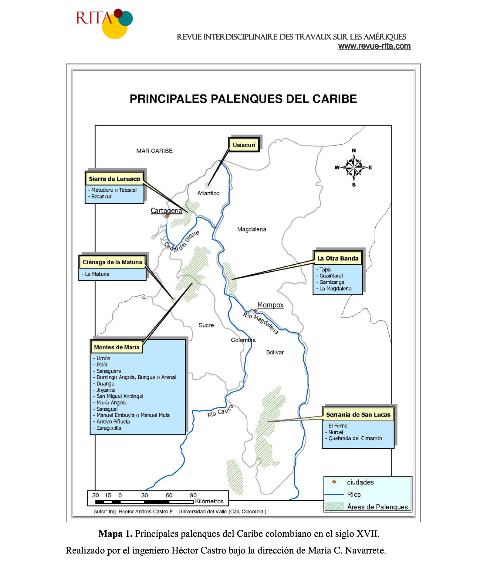
Dispossesions in the Americas

Dispossesions in the Americas

  • Home
  • Explore
  • About
  • Authors
  • Art
  • Bodies
  • Curricula
  • Cultural Heritage
  • Maps
  • Territories
Back to Explore
Map 1600 - 1699

PRINCIPALES PALENQUES DEL CARIBE

  • MARIA NAVARRETE

Published: 2012

  • Download Image

Citation

Navarrete P, Maria Cristina. "Los cimarrones de la provincia de Cartagena de Indias en el siglo XVII: Relaciones, diferencias y politicas de las autoridades", RITA, N°5 : diciembre 2011, (en línea), Puesto en línea el 15 de diciembre de 2011. Disponible en línea http://www.revue-rita.com/dossier-thema-61/los-cimarrones-de-la-provincia-de-cartagena-de-indias-en-el-siglo-xvii-relaciones-diferencias-y-politicas-de-las-autoridades.html.(Mapa1.PrincipalespalenquesdelCaribecolombianoenelsigloXVII.RealizadoporelingenieroHéctorCastrobajoladireccióndeMaríaC.Navarrete.2012)

  • Download Image

Reading in Spanish

Map 1600 - 1699

PRINCIPALES PALENQUES DEL CARIBE

  • MARIA NAVARRETE

Published: 2012

  • Download Image
  • Download Image

Reading in Portuguese

Map 1600 - 1699

PRINCIPALES PALENQUES DEL CARIBE

  • MARIA NAVARRETE

Published: 2012

  • Download Image

Citation

Navarrete P, Maria Cristina. "Los cimarrones de la provincia de Cartagena de Indias en el siglo XVII: Relaciones, diferencias y politicas de las autoridades", RITA, N°5 : diciembre 2011, (en línea), Puesto en línea el 15 de diciembre de 2011. Disponible en línea http://www.revue-rita.com/dossier-thema-61/los-cimarrones-de-la-provincia-de-cartagena-de-indias-en-el-siglo-xvii-relaciones-diferencias-y-politicas-de-las-autoridades.html.(Mapa1.PrincipalespalenquesdelCaribecolombianoenelsigloXVII.RealizadoporelingenieroHéctorCastrobajoladireccióndeMaríaC.Navarrete.2012)

  • Download Image

Related Content

Idiomas Mayas

Idiomas Mayas

Map 1970
No Title

No Title

Map 2015
Serie Fatherland / Padre Patria

Serie Fatherland / Padre Patria

Artwork
RESGUARDO INDÍGENA DE GUAMBÍA

RESGUARDO INDÍGENA DE GUAMBÍA

Map 1981
REGIÓN TUXTLAS, POPOLUCA-NÁHUATL DE VERACRUZ

REGIÓN TUXTLAS, POPOLUCA-NÁHUATL DE VERACRUZ

Map 2000
PROVINCIA DE MATTO GROSSO

PROVINCIA DE MATTO GROSSO

Map 1800 - 1850
Carte de Colombie et des Guyanes

Carte de Colombie et des Guyanes

Map 1800 - 1899
Mapa de resguardos indígenas

Mapa de resguardos indígenas

Map 2012

Dispossessions in the Americas

A project by

University of Pennsylvania

Copyright 2024

With support from

Mellon Foundation

Site design & development

Element 84

Art Credits

Navarrete P, Maria Cristina. “Los cimarrones de la provincia de Cartagena de Indias en el siglo XVII: Relaciones, diferencias y politicas de las autoridades”, RITA, N°5 : diciembre 2011, (en línea), Puesto en línea el 15 de diciembre de 2011. Disponible en línea http://www.revue-rita.com/dossier-thema-61/los-cimarrones-de-la-provincia-de-cartagena-de-indias-en-el-siglo-xvii-relaciones-diferencias-y-politicas-de-las-autoridades.html.(Mapa1.PrincipalespalenquesdelCaribecolombianoenelsigloXVII.RealizadoporelingenieroHéctorCastrobajoladireccióndeMaríaC.Navarrete.2012)

Site Pages

  • Home
  • Explore
  • About
  • Authors
  • Art
  • Bodies
  • Curricula
  • Cultural Heritage
  • Maps
  • Territories