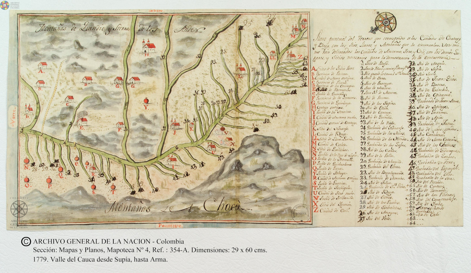
Dispossesions in the Americas

Dispossesions in the Americas

  • Home
  • Explore
  • About
  • Authors
  • Art
  • Bodies
  • Curricula
  • Cultural Heritage
  • Maps
  • Territories
Back to Explore
Map 1779

Plano puntual del terreno que corresponde a las ciudades de Cartago y Buga con los rios, llanos, y montañas que las circunvalan.

    Published: 1779

    • Download Image

    Peoples

    • POZOS
    • PACURA
    • PICARA
    • CARRAPAS
    • QUICHIAS
    • GORRONES
    • QUIMBAYA

    Citation

    ARCHIVO GENERAL DE LA NACIÓN DE COLOMBIA. SECCIÓN MAPAS Y PLANOS;Mapoteca: VALLE DEL CUACA DESDE UPIA HASTA ARMA - CO.AGN.SMP.2.REF.1064. 1779 https://d3nmwx7scpuzgc.cloudfront.net/sites/default/files/media/image/mapa-valle-del-cauca-desde-supia-hasta-arma-1.3.3.a.jpg

    • Download Image

    Reading in Spanish

    Map 1779

    Plano puntual del terreno que corresponde a las ciudades de Cartago y Buga con los rios, llanos, y montañas que las circunvalan.

      Published: 1779

      • Download Image
      • Download Image

      Reading in Portuguese

      Map 1779

      Plano puntual del terreno que corresponde a las ciudades de Cartago y Buga con los rios, llanos, y montañas que las circunvalan.

        Published: 1779

        • Download Image

        Peoples

        • POZOS
        • PACURA
        • PICARA
        • CARRAPAS
        • QUICHIAS
        • GORRONES
        • QUIMBAYA

        Citation

        ARCHIVO GENERAL DE LA NACIÓN DE COLOMBIA. SECCIÓN MAPAS Y PLANOS;Mapoteca: VALLE DEL CUACA DESDE UPIA HASTA ARMA - CO.AGN.SMP.2.REF.1064. 1779 https://d3nmwx7scpuzgc.cloudfront.net/sites/default/files/media/image/mapa-valle-del-cauca-desde-supia-hasta-arma-1.3.3.a.jpg

        • Download Image

        Related Content

        BRASIL

        BRASIL

        Map 1800 - 1899
        Croquis III. (b) La región andina septentrional ecuatoriana (Moreno Yanez;1989;2)

        Croquis III. (b) La región andina septentrional ecuatoriana (Moreno Yanez;1989;2)

        Map -500 - 1530
        DURANGO

        DURANGO

        Map 2015
        Plano de Quetzaltenango, Guatemala.

        Plano de Quetzaltenango, Guatemala.

        Map 1800
        CARTA ETNOGRÁFICA

        CARTA ETNOGRÁFICA

        Map 1885
        CARTA DO RIO IÇA

        CARTA DO RIO IÇA

        Map 1868
        Planta regular de la fortaleza y castillo de Huehuetenango, sobre las márgenas de Socoleo.

        Planta regular de la fortaleza y castillo de Huehuetenango, sobre las márgenas de Socoleo.

        Map 1672
        PUEBLO MASHCO PIRO

        PUEBLO MASHCO PIRO

        Map 2021

        Dispossessions in the Americas

        A project by

        University of Pennsylvania

        Copyright 2024

        With support from

        Mellon Foundation

        Site design & development

        Element 84

        Art Credits

        ARCHIVO GENERAL DE LA NACIÓN DE COLOMBIA. SECCIÓN MAPAS Y PLANOS;Mapoteca: VALLE DEL CUACA DESDE UPIA HASTA ARMA - CO.AGN.SMP.2.REF.1064. 1779 https://d3nmwx7scpuzgc.cloudfront.net/sites/default/files/media/image/mapa-valle-del-cauca-desde-supia-hasta-arma-1.3.3.a.jpg

        Site Pages

        • Home
        • Explore
        • About
        • Authors
        • Art
        • Bodies
        • Curricula
        • Cultural Heritage
        • Maps
        • Territories