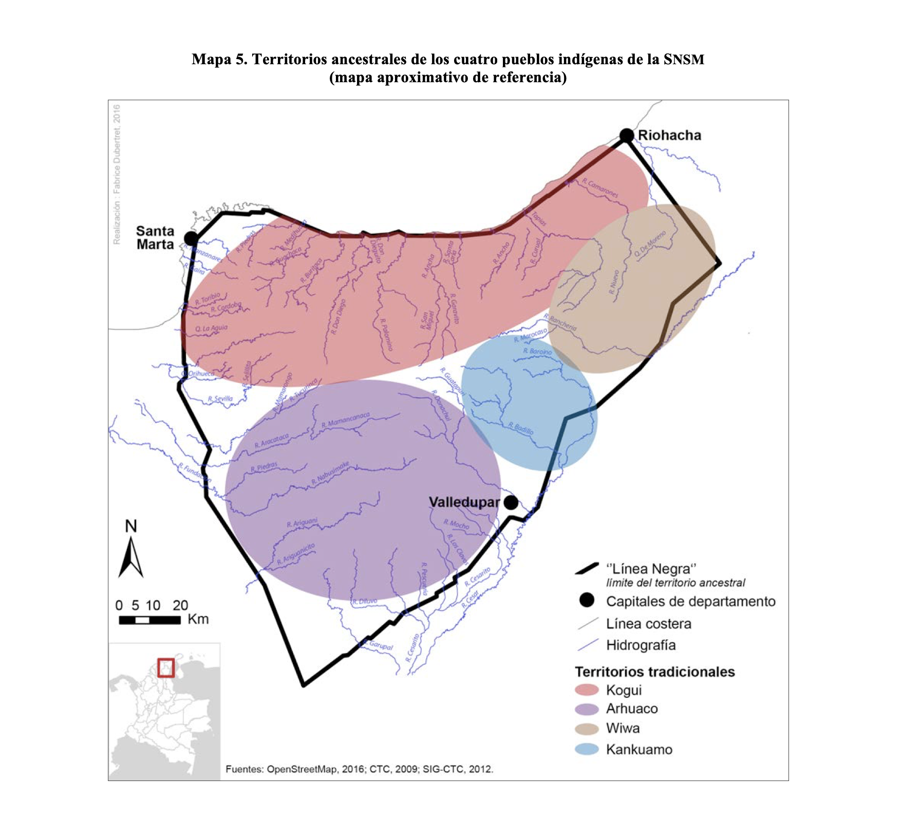
Dispossesions in the Americas

Dispossesions in the Americas

  • Home
  • Explore
  • About
  • Authors
  • Art
  • Bodies
  • Curricula
  • Cultural Heritage
  • Maps
  • Territories
Back to Explore
Map 2009

TERRITORIOS ANCESTRALES DE LOS CUATRO PUEBLOS INDIGENAS DE LA SSNM (MAPA APROXIMATIVO DE REFERENCIA)

  • OPENSTREETMAP, INCODER, SIG-CTC, CTC

Published: 2016

  • Download Image

Peoples

  • KOGUI
  • ARHUACO
  • KANKUAMO
  • WIWA

Citation

Valderrama Gonzalez, Maria Isabel. "Limites de la gobernanza en territorio indigena: Representaciones y discursos alrededor del ordenamiento territorial en la Sierra Nevada de Santa Marta (Colombia)." PhD diss., Ecole des Hautes Etudes en Sciences Sociales, 2016. Accessed June 17, 2021. https://tel.archives-ouvertes.fr/tel-01472501/document.

  • Download Image

Reading in Spanish

Map 2009

TERRITORIOS ANCESTRALES DE LOS CUATRO PUEBLOS INDIGENAS DE LA SSNM (MAPA APROXIMATIVO DE REFERENCIA)

  • OPENSTREETMAP, INCODER, SIG-CTC, CTC

Published: 2016

  • Download Image
  • Download Image

Reading in Portuguese

Map 2009

TERRITORIOS ANCESTRALES DE LOS CUATRO PUEBLOS INDIGENAS DE LA SSNM (MAPA APROXIMATIVO DE REFERENCIA)

  • OPENSTREETMAP, INCODER, SIG-CTC, CTC

Published: 2016

  • Download Image

Peoples

  • KOGUI
  • ARHUACO
  • KANKUAMO
  • WIWA

Citation

Valderrama Gonzalez, Maria Isabel. "Limites de la gobernanza en territorio indigena: Representaciones y discursos alrededor del ordenamiento territorial en la Sierra Nevada de Santa Marta (Colombia)." PhD diss., Ecole des Hautes Etudes en Sciences Sociales, 2016. Accessed June 17, 2021. https://tel.archives-ouvertes.fr/tel-01472501/document.

  • Download Image

Related Content

QUINTANA ROO

QUINTANA ROO

Map 2015
Plan de la Rivière de Kourou et de la mission.

Plan de la Rivière de Kourou et de la mission.

Map 1700 - 1799
La región andina central ecuatoriana

La región andina central ecuatoriana

Map -500 - 1550
Guiana Shewing the Localities of the Principal Indian Nations

Guiana Shewing the Localities of the Principal Indian Nations

Map 1800 - 1899
PUEBLO PAPAGO

PUEBLO PAPAGO

Map 2020
THE RÍO NEGRO

THE RÍO NEGRO

Map 1851 - 1852
NEW GRANADA

NEW GRANADA

Map 1811
Territorios del Pueblo Barí reconocidos por el Estado Colombiano (2017)

Territorios del Pueblo Barí reconocidos por el Estado Colombiano (2017)

Map 2017

Dispossessions in the Americas

A project by

University of Pennsylvania

Copyright 2024

With support from

Mellon Foundation

Site design & development

Element 84

Art Credits

Valderrama Gonzalez, Maria Isabel. “Limites de la gobernanza en territorio indigena: Representaciones y discursos alrededor del ordenamiento territorial en la Sierra Nevada de Santa Marta (Colombia).” PhD diss., Ecole des Hautes Etudes en Sciences Sociales, 2016. Accessed June 17, 2021. https://tel.archives-ouvertes.fr/tel-01472501/document.

Site Pages

  • Home
  • Explore
  • About
  • Authors
  • Art
  • Bodies
  • Curricula
  • Cultural Heritage
  • Maps
  • Territories