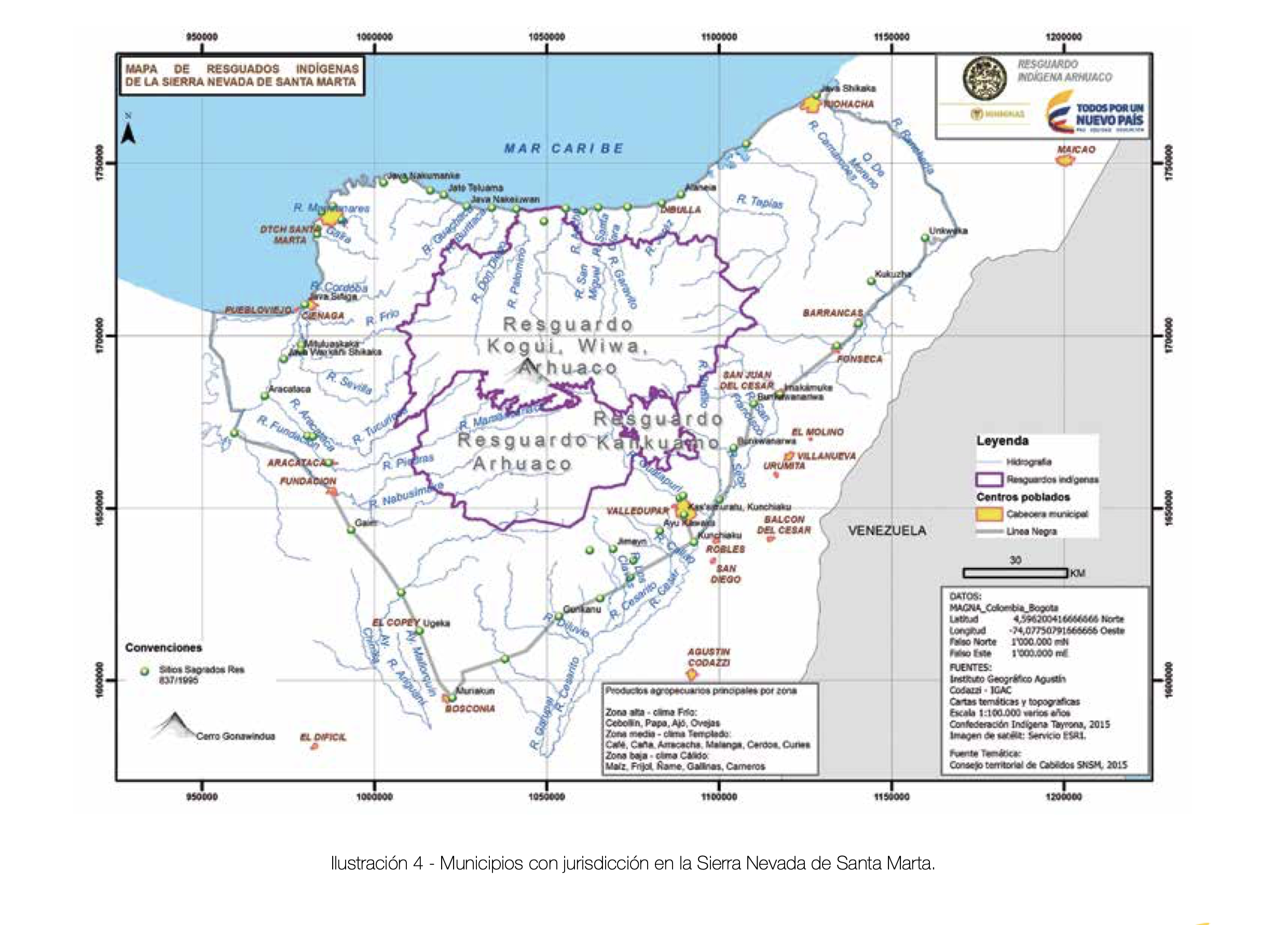
Dispossesions in the Americas

Dispossesions in the Americas

  • Home
  • Explore
  • About
  • Authors
  • Art
  • Bodies
  • Curricula
  • Cultural Heritage
  • Maps
  • Territories
Back to Explore
Map 2015

MUNICIPIOS CON JURISDICCION EN LA SIERRA NEVADA DE SANTA MARIA

  • RESGUARDO INDIGENA ARHUACO, MINISTERIO DE MINAS Y ENERGÍA

Published: 2015

  • Download Image

Peoples

  • KOGUI
  • ARHUACO
  • KANKUAMO
  • WIWA

Citation

República de Colombia Ministerio de Minas y Energia. Entendimiento mutuo para el cuidado de nuestro territorio: guía de relacionamiento y diálogo entre el sector minero-energético y el pueblo Arhuaco. By Equipo de Apoyo Técnico. Compiled by Reinaldo Izquierdo Solís. October 2015. Accessed June 18, 2021. https://www.minenergia.gov.co/documents/10192/23873954/6.+Guia+de+Relacionamiento+Arahuaco.pdf/4acaa2a1-d9fc-4bd0-8862-54f92cc789e3.

  • Download Image

Reading in Spanish

Map 2015

MUNICIPIOS CON JURISDICCION EN LA SIERRA NEVADA DE SANTA MARIA

  • RESGUARDO INDIGENA ARHUACO, MINISTERIO DE MINAS Y ENERGÍA

Published: 2015

  • Download Image
  • Download Image

Related Content

Blue Creek

Blue Creek

Map 1997
GUERRERO

GUERRERO

Map 2015
REGIÓN NORTE DE CHIAPAS

REGIÓN NORTE DE CHIAPAS

Map 2000
Carte de la Guïane françoise ou du gouvernement de Caïenne depuis le Cap de Nord jusqu'àla rivière de Maroni inclusivement.

Carte de la Guïane françoise ou du gouvernement de Caïenne depuis le Cap de Nord jusqu'àla rivière de Maroni inclusivement.

Map 1729
Geographic Map of the Nicaragua with three plans and views.

Geographic Map of the Nicaragua with three plans and views.

Map 1855
TERRITORIO DEL PUEBLO SHUAR ATRUAM

TERRITORIO DEL PUEBLO SHUAR ATRUAM

Map 2017
Government map of Nicaragua : from the latest surveys ordered by President Patricio Rivas and Genl. William Walker ;executed under the supervision of the Señor Fermín Ferrer;Governor of the Western Department;1856

Government map of Nicaragua : from the latest surveys ordered by President Patricio Rivas and Genl. William Walker ;executed under the supervision of the Señor Fermín Ferrer;Governor of the Western Department;1856

Map 1800 - 1856
The modern departments of Ahuachapán, La Libertad, Santa Ana, and Sonsonate (highlighted in red) now contain the highest concentration of Indigenous communities in El Salvador.

The modern departments of Ahuachapán, La Libertad, Santa Ana, and Sonsonate (highlighted in red) now contain the highest concentration of Indigenous communities in El Salvador.

Map 2010

Dispossessions in the Americas

A project by

University of Pennsylvania

Copyright 2024

With support from

Mellon Foundation

Site design & development

Element 84

Art Credits

República de Colombia Ministerio de Minas y Energia. Entendimiento mutuo para el cuidado de nuestro territorio: guía de relacionamiento y diálogo entre el sector minero-energético y el pueblo Arhuaco. By Equipo de Apoyo Técnico. Compiled by Reinaldo Izquierdo Solís. October 2015. Accessed June 18, 2021. https://www.minenergia.gov.co/documents/10192/23873954/6.+Guia+de+Relacionamiento+Arahuaco.pdf/4acaa2a1-d9fc-4bd0-8862-54f92cc789e3.

Site Pages

  • Home
  • Explore
  • About
  • Authors
  • Art
  • Bodies
  • Curricula
  • Cultural Heritage
  • Maps
  • Territories