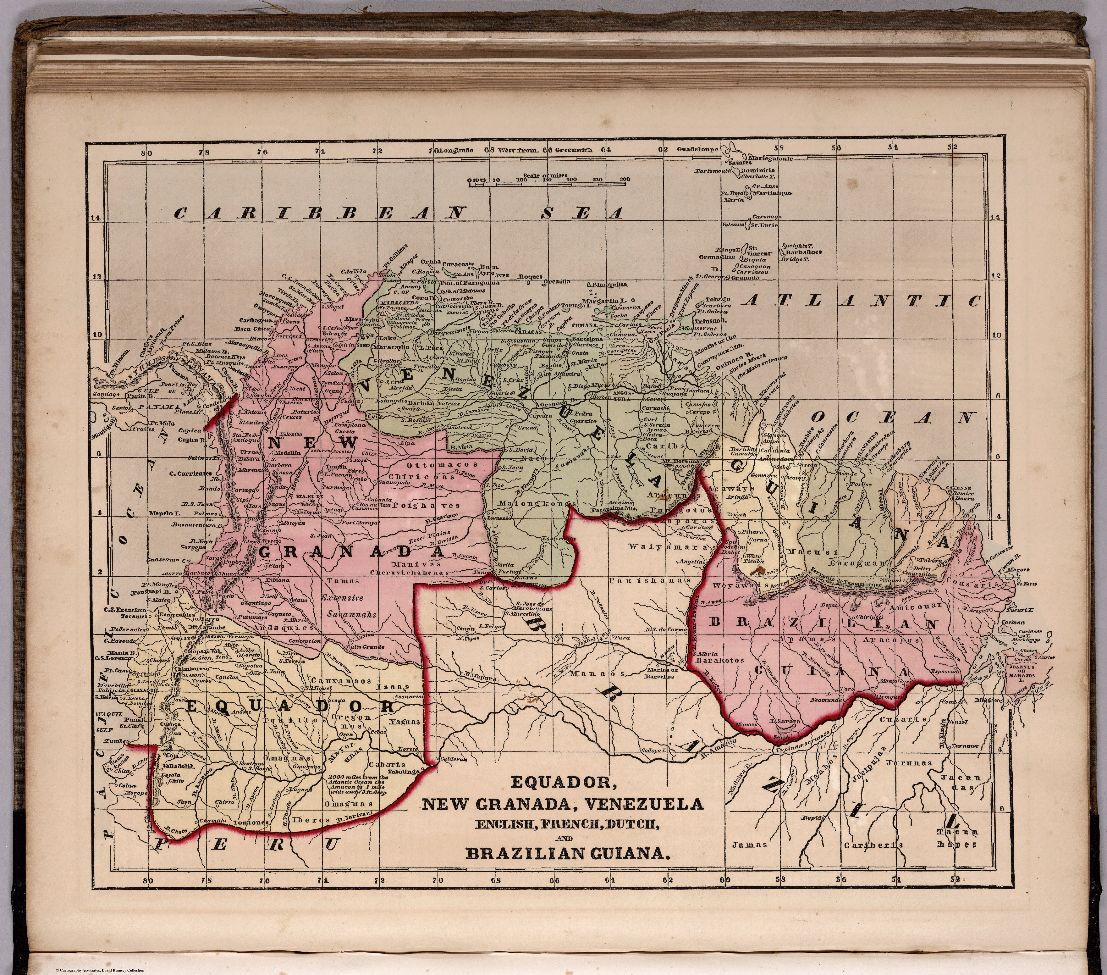
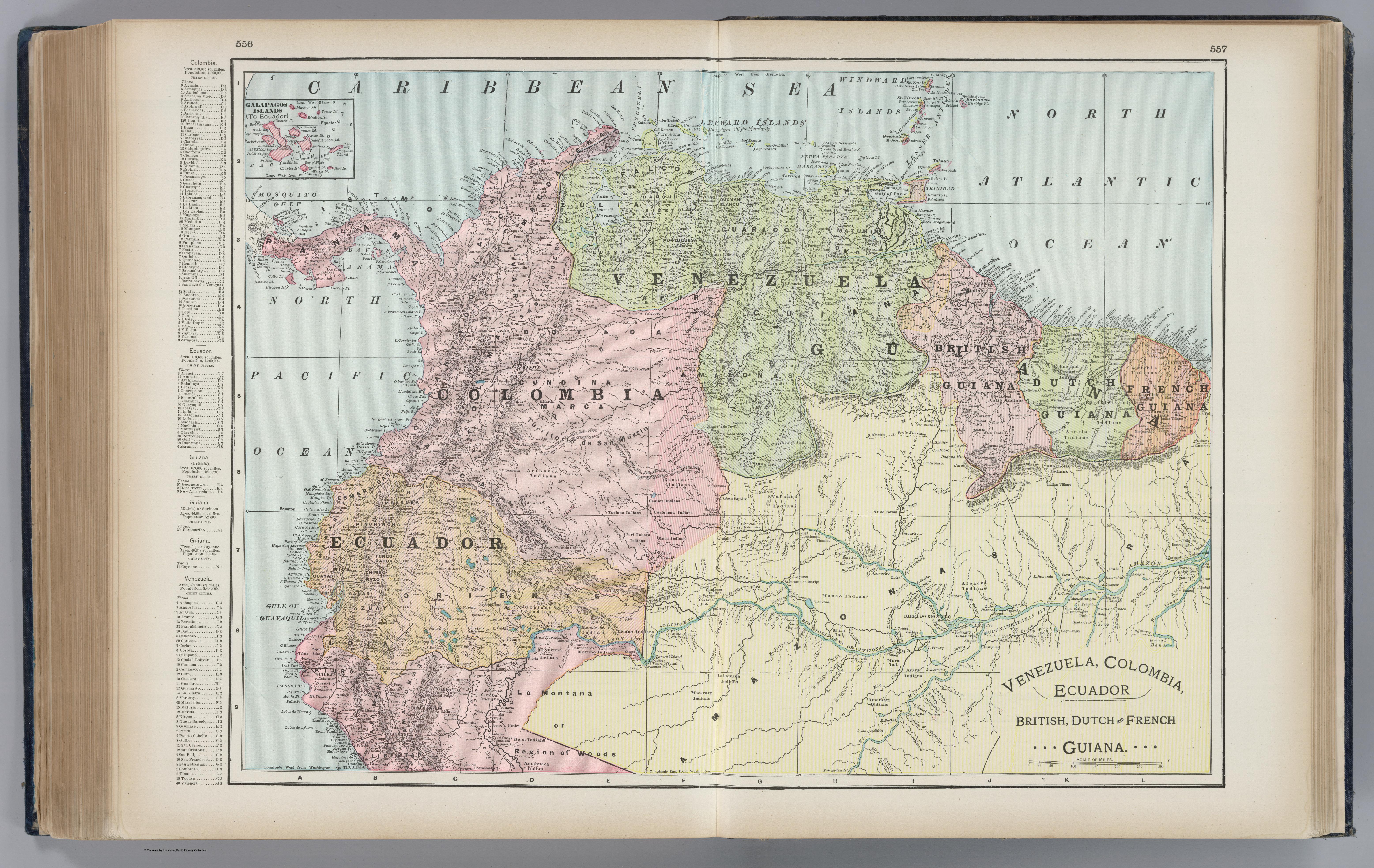
Dispossesions in the Americas

Dispossesions in the Americas

  • Home
  • Explore
  • About
  • Authors
  • Art
  • Bodies
  • Curricula
  • Cultural Heritage
  • Maps
  • Territories
Back to Explore
Map 1901

Venezuela, Colombia, Ecuador;British, Dutch, and French Guiana

  • Cram, George Franklin

Published: 1901

  • Download Image

Peoples

  • ACURIA
  • AETHONIA
  • AGUARICOTO
  • AKAWI
  • AMAHUACA
  • AMAMATI
  • ARARA
  • ARAWAK
  • ARINOGOTO
  • AROAQUI
  • AUKAU
  • AVERIANO
  • AYANO
  • AZARENI
  • BANILAS
  • CAMARACOTO
  • CANIARI
  • CANIXANA
  • CARIB
  • CASIBO
  • CATUQUINA
  • CUNIBA
  • CUNIPASANA
  • CURIARANA
  • EMERILLON
  • GALIBI
  • GUALEA
  • GUAHIBO
  • GUAIAUNO
  • GUAINARE
  • GUINAN
  • JURI-TABOCO
  • KIRIKIRICOTOS
  • MACARARY
  • MACO
  • MACU
  • MACUSI
  • MACUENI
  • MANAOS
  • MAQUIRITARE
  • MARUBO
  • MATAARIE
  • MAYONOCO
  • MAYURUNA
  • MURA
  • NOURAGUE
  • OREJONE
  • PARABENA
  • PARIANA
  • PAUXIANA
  • PIANOGHOTTO
  • PIAROAS
  • PURIGOTO
  • REBO
  • QUIRIQUIRIPO
  • REKOE
  • TARIANA
  • TARUMA
  • TAPANITTO
  • TICUNA
  • UARIQUENA
  • WAIKA
  • XEBERO
  • YABAANA
  • YAGUA

Citation

Cram, George Franklin. Venezuela, Colombia, Ecuador, British, Dutch, and French Guiana. David Rumsey Map Collection. Accessed, April 10, 2024. https://www.davidrumsey.com/luna/servlet/detail/RUMSEY~8~1~213476~5501027

  • Download Image

Reading in Spanish

Map 1901

Venezuela, Colombia, Ecuador;British, Dutch, and French Guiana

  • Cram, George Franklin

Published: 1901

  • Download Image
  • Download Image

Related Content

Current Ethno-Linguistic Groups of South America

Current Ethno-Linguistic Groups of South America

Map 1990
TERRITORIO DEL SEÑORÍO AYMARA DE LOS QARAQARA EN EL SIGLO XVI

TERRITORIO DEL SEÑORÍO AYMARA DE LOS QARAQARA EN EL SIGLO XVI

Map 1530
BRAZIL

BRAZIL

Map 1905
Carte Du Paraguay et partie des Pays adjacants

Carte Du Paraguay et partie des Pays adjacants

Map 1771
LE PARAGUAY Tiré des Relations les plus Récentes.

LE PARAGUAY Tiré des Relations les plus Récentes.

Map 1668
PUEBLO OCAINA

PUEBLO OCAINA

Map 2021
Carta topográfica de la Pampa y de la línea de defensa contra los indios.

Carta topográfica de la Pampa y de la línea de defensa contra los indios.

Map 1875
Map of the Inca Empire

Map of the Inca Empire

Map 1490 - 1499

Dispossessions in the Americas

A project by

University of Pennsylvania

Copyright 2024

With support from

Mellon Foundation

Site design & development

Element 84

Art Credits

Cram, George Franklin. Venezuela, Colombia, Ecuador, British, Dutch, and French Guiana. David Rumsey Map Collection. Accessed, April 10, 2024. https://www.davidrumsey.com/luna/servlet/detail/RUMSEY~8~1~213476~5501027

Site Pages

  • Home
  • Explore
  • About
  • Authors
  • Art
  • Bodies
  • Curricula
  • Cultural Heritage
  • Maps
  • Territories