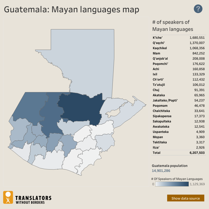
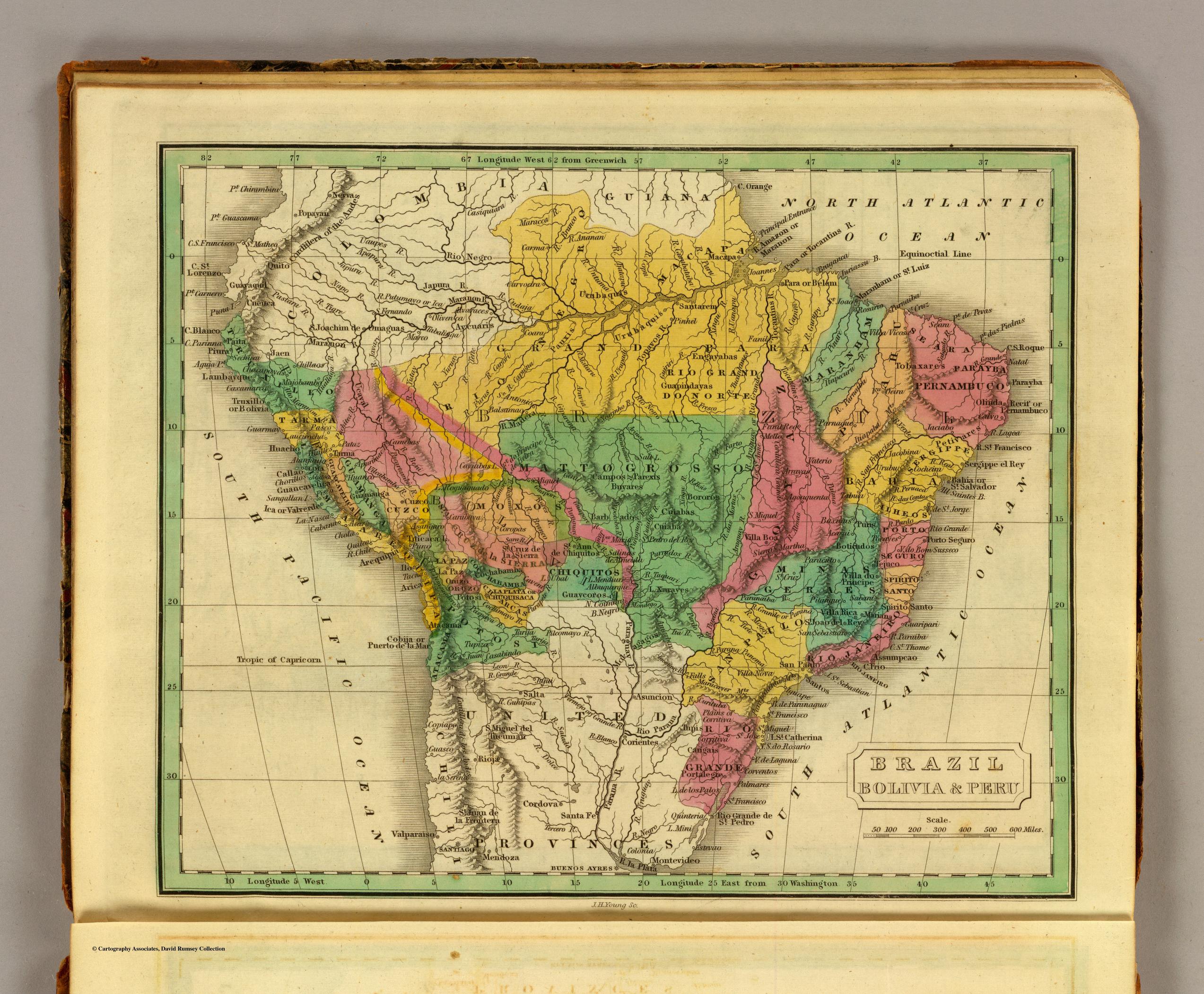
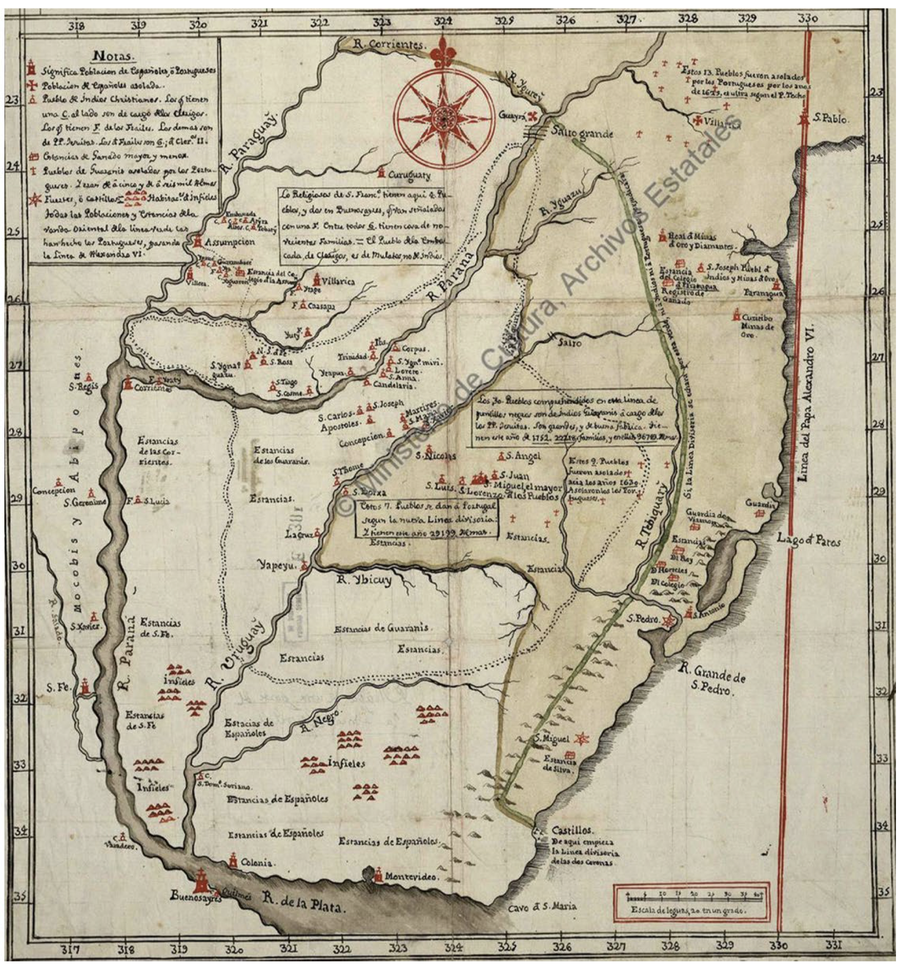
Dispossesions in the Americas

Dispossesions in the Americas

  • Home
  • Explore
  • About
  • Authors
  • Art
  • Bodies
  • Curricula
  • Cultural Heritage
  • Maps
  • Territories
Back to Explore
Map 1865

Mapa general del Perú

  • Mariano Felipe Paz Soldan

Published: 1865

  • Download Image

Peoples

  • OREJONES
  • IQUITOS
  • ABIQUIRAS
  • ENCABELLADOS
  • CURGUIES
  • PAYAGUAS
  • TICUNAS
  • MARUBOS
  • MAYURUNAS
  • OMAGUAS
  • COCAMAS
  • ROUMINAS
  • YAMEOS
  • UCHUCAS
  • JIVAROS
  • TUCALES
  • CUNIBAS
  • PIROS
  • REMOS
  • AMAHUACAS
  • CASIBOS
  • CAMPAS

Citation

Paz Soldan, M. F. (Cartographer). (1865). Mapa general del Peru [Map]. Libreria de Augusto Durand. David Rumsey. https://www.davidrumsey.com/luna/servlet/s/djr976

  • Download Image

Reading in Spanish

Map 1865

Mapa general del Perú

  • Mariano Felipe Paz Soldan

Published: 1865

  • Download Image
  • Download Image

Reading in Portuguese

Map 1865

Mapa general del Perú

  • Mariano Felipe Paz Soldan

Published: 1865

  • Download Image

Peoples

  • OREJONES
  • IQUITOS
  • ABIQUIRAS
  • ENCABELLADOS
  • CURGUIES
  • PAYAGUAS
  • TICUNAS
  • MARUBOS
  • MAYURUNAS
  • OMAGUAS
  • COCAMAS
  • ROUMINAS
  • YAMEOS
  • UCHUCAS
  • JIVAROS
  • TUCALES
  • CUNIBAS
  • PIROS
  • REMOS
  • AMAHUACAS
  • CASIBOS
  • CAMPAS

Citation

Paz Soldan, M. F. (Cartographer). (1865). Mapa general del Peru [Map]. Libreria de Augusto Durand. David Rumsey. https://www.davidrumsey.com/luna/servlet/s/djr976

  • Download Image

Related Content

Guatemala: Mayan languages map

Guatemala: Mayan languages map

Map 2018
Cartografía social – confinamiento por la expansión minera en el sur de La Guajira

Cartografía social – confinamiento por la expansión minera en el sur de La Guajira

Map
PUEBLO NAHUA DE DURANGO

PUEBLO NAHUA DE DURANGO

Map 2020
BRAZIL BOLIVIA & PERU

BRAZIL BOLIVIA & PERU

Map 1830
Mapa De La Gobernación Del Paraguay Y Buenos Aires, Con La Línea  Divisoria De Las Tierras De España Y Portugal_1752.

Mapa De La Gobernación Del Paraguay Y Buenos Aires, Con La Línea Divisoria De Las Tierras De España Y Portugal_1752.

Map 1752
Etnias Norte Grande

Etnias Norte Grande

Map 2015
Confluent de l'Amazone, de l'Urubu et du Uatuma, confluent de l'Amazone et du Madeira

Confluent de l'Amazone, de l'Urubu et du Uatuma, confluent de l'Amazone et du Madeira

Map 1729
Mayan Access to Biomass Resources (Guatemala 2018).

Mayan Access to Biomass Resources (Guatemala 2018).

Map 2000

Dispossessions in the Americas

A project by

University of Pennsylvania

Copyright 2024

With support from

Mellon Foundation

Site design & development

Element 84

Art Credits

Paz Soldan, M. F. (Cartographer). (1865). Mapa general del Peru [Map]. Libreria de Augusto Durand. David Rumsey. https://www.davidrumsey.com/luna/servlet/s/djr976

Site Pages

  • Home
  • Explore
  • About
  • Authors
  • Art
  • Bodies
  • Curricula
  • Cultural Heritage
  • Maps
  • Territories