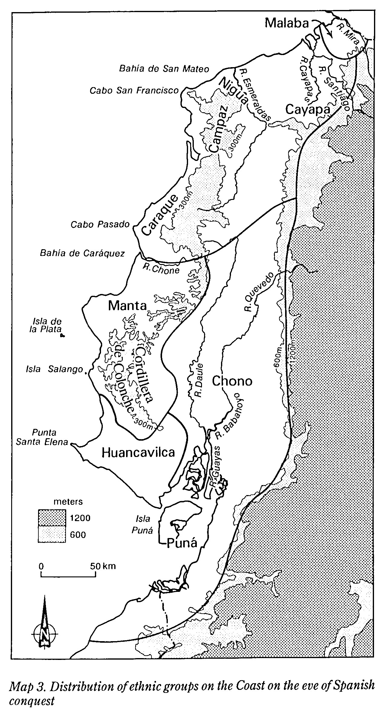
Dispossesions in the Americas

Dispossesions in the Americas

  • Home
  • Explore
  • About
  • Authors
  • Art
  • Bodies
  • Curricula
  • Cultural Heritage
  • Maps
  • Territories
Back to Explore
Map 1800 - 1899

Guiana Shewing the Localities of the Principal Indian Nations

  • Brett, W. H.

Published: 1868

  • Download Image

Peoples

  • ACAWOIOS
  • ACCOCRIS
  • AMORUAS
  • ARAMISAS
  • ARAWAKS
  • ARECUNAS
  • ARINAGOTOS
  • ATORAIS
  • CADUPINAPOS
  • CARIBS
  • COUSSARIS
  • CUINAUS
  • CUNIPASANOS
  • CURIANOS
  • CURUCHIPANOS
  • EMERILLONS
  • GALIBIS
  • GUAHIBOS
  • GUAHARIBOS
  • GUAICAS
  • GUAINARES
  • GUAIPUNAVOS
  • KAMAROCOTOS
  • KIRIHANAS
  • KIRISHANAS
  • MACOS
  • MACUSIS
  • MAIONGKONGS
  • MANITIVITANOS
  • MAPOYES
  • MARIQUITARES
  • OAVACAS
  • OYAMPIS
  • PANARES
  • PIAROAS
  • PURIGOTOS
  • ROCOUYENNES
  • TAPARITOS
  • TARUMAS
  • WAIKAS
  • WAPISIANAS
  • WARAUS
  • WOYAWAIS
  • YABANOS
  • ZAPARAS

Citation

Brett, W. H., The Indian tribes of Guiana , the condition and habits. Hathi Trust, Accessed, August 21, 2023. https://hdl.handle.net/2027/coo1.ark:/13960/t04x5vb40?urlappend=%3Bseq=561

  • Download Image

Reading in Spanish

Map 1800 - 1899

Guiana Shewing the Localities of the Principal Indian Nations

  • Brett, W. H.

Published: 1868

  • Download Image
  • Download Image

Reading in Portuguese

Map 1800 - 1899

Guiana Shewing the Localities of the Principal Indian Nations

  • Brett, W. H.

Published: 1868

  • Download Image

Peoples

  • ACAWOIOS
  • ACCOCRIS
  • AMORUAS
  • ARAMISAS
  • ARAWAKS
  • ARECUNAS
  • ARINAGOTOS
  • ATORAIS
  • CADUPINAPOS
  • CARIBS
  • COUSSARIS
  • CUINAUS
  • CUNIPASANOS
  • CURIANOS
  • CURUCHIPANOS
  • EMERILLONS
  • GALIBIS
  • GUAHIBOS
  • GUAHARIBOS
  • GUAICAS
  • GUAINARES
  • GUAIPUNAVOS
  • KAMAROCOTOS
  • KIRIHANAS
  • KIRISHANAS
  • MACOS
  • MACUSIS
  • MAIONGKONGS
  • MANITIVITANOS
  • MAPOYES
  • MARIQUITARES
  • OAVACAS
  • OYAMPIS
  • PANARES
  • PIAROAS
  • PURIGOTOS
  • ROCOUYENNES
  • TAPARITOS
  • TARUMAS
  • WAIKAS
  • WAPISIANAS
  • WARAUS
  • WOYAWAIS
  • YABANOS
  • ZAPARAS

Citation

Brett, W. H., The Indian tribes of Guiana , the condition and habits. Hathi Trust, Accessed, August 21, 2023. https://hdl.handle.net/2027/coo1.ark:/13960/t04x5vb40?urlappend=%3Bseq=561

  • Download Image

Related Content

MAP 3. DISTRIBUTION OF ETHNIC GROUPS OF THE COAST ON THE EVE OF SPANISH CONQUEST

MAP 3. DISTRIBUTION OF ETHNIC GROUPS OF THE COAST ON THE EVE OF SPANISH CONQUEST

Map 1490
Población o'ob (pima) en 2010

Población o'ob (pima) en 2010

Map 2010
Plano geográfico de las provincias y terrenos confinantes a la Talamanca con demostración de su montañas, situaciones, etc.

Plano geográfico de las provincias y terrenos confinantes a la Talamanca con demostración de su montañas, situaciones, etc.

Map 1781
DISTRIBUTION OF PRINCIPAL NATIONS AFTER 1300 AD

DISTRIBUTION OF PRINCIPAL NATIONS AFTER 1300 AD

Map 1300
This is a description of the Isle of Pines and Golden Island / William Hacke

This is a description of the Isle of Pines and Golden Island / William Hacke

Map 1688
Mapa que remitió de su corregimiento Macuisuchil y Teutitlan

Mapa que remitió de su corregimiento Macuisuchil y Teutitlan

Map 1580
GUANÁ

GUANÁ

Map 2015
LE BRESIL dont les côtes sont Divisées en Capitainerie

LE BRESIL dont les côtes sont Divisées en Capitainerie

Map 1719

Dispossessions in the Americas

A project by

University of Pennsylvania

Copyright 2024

With support from

Mellon Foundation

Site design & development

Element 84

Art Credits

Brett, W. H., The Indian tribes of Guiana , the condition and habits. Hathi Trust, Accessed, August 21, 2023. https://hdl.handle.net/2027/coo1.ark:/13960/t04x5vb40?urlappend=%3Bseq=561

Site Pages

  • Home
  • Explore
  • About
  • Authors
  • Art
  • Bodies
  • Curricula
  • Cultural Heritage
  • Maps
  • Territories