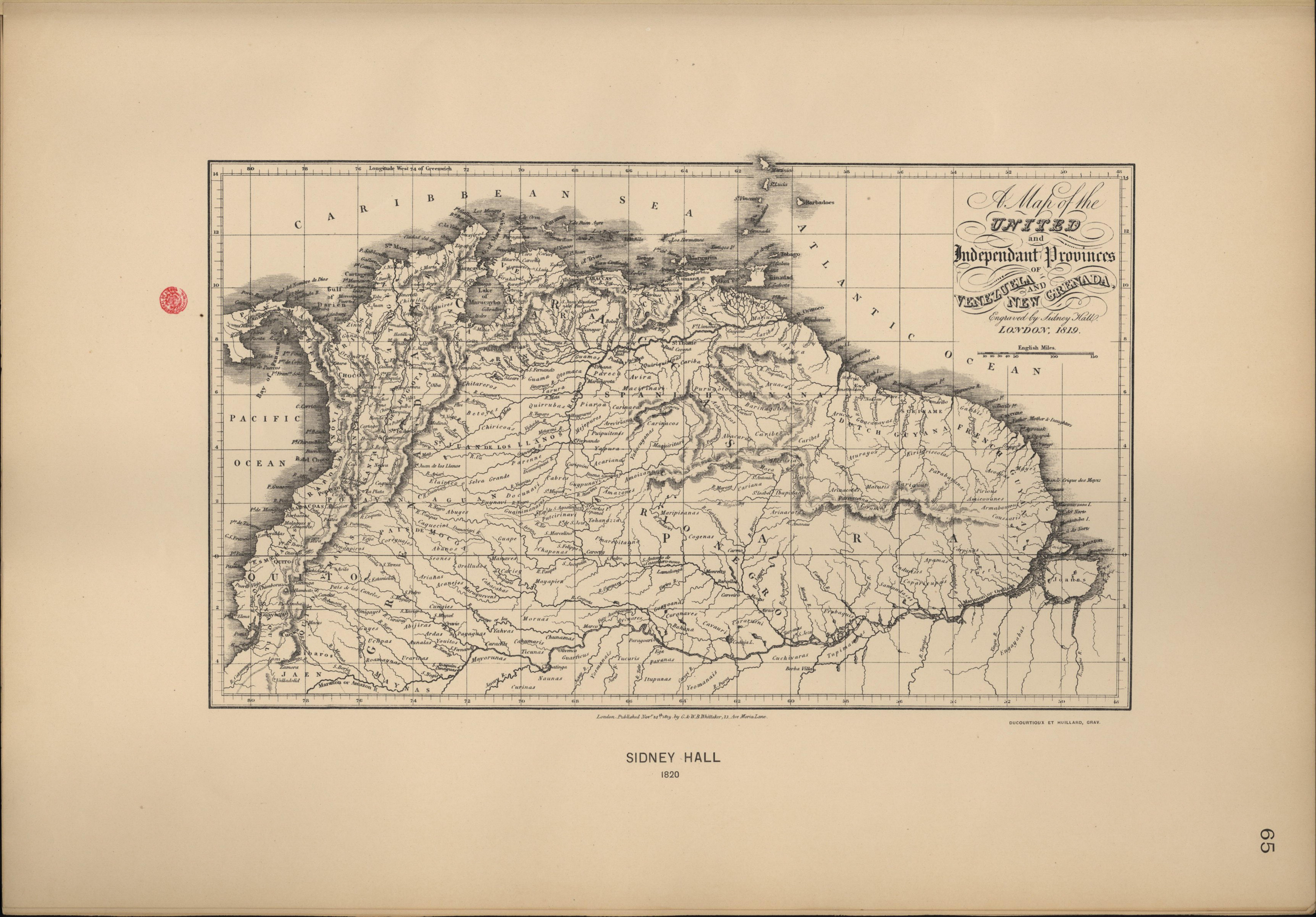
Dispossesions in the Americas

Dispossesions in the Americas

  • Home
  • Explore
  • About
  • Authors
  • Art
  • Bodies
  • Curricula
  • Cultural Heritage
  • Maps
  • Territories
Back to Explore
Map 1800 - 1899

A Map of the United and Independant Provinces of Venezuela and New Grenada.

  • Hall, Sidney

Published: 1819

  • Download Image

Peoples

  • ABACARUS
  • ABANOS
  • ABIJIRAS
  • ABUYES
  • ACANEJOS
  • ACARIANAS
  • ACHIRIGOTOS
  • ACOQUAS
  • AMAZONES
  • AMICOUANES
  • AMOIZANNA
  • APAMAS
  • ARDAS
  • ARIANAS
  • AREVIRIANA
  • ARINACOTAS
  • ARMABOUIOUS
  • ARUACAS
  • ARUCAS
  • AVIRA
  • ATURAYOS
  • AUNALES
  • AVERARES
  • BAHONA
  • BARINAGOTOS
  • BETOYES
  • CABACABAS
  • CABRES
  • CAQUECIOS
  • CARACHIS
  • CARARENI
  • CARIANA
  • CARIBA
  • CARIBES
  • CARIEY
  • CARIGUAN
  • CARINACA
  • CARINACOS
  • CARPINUS
  • CAVAURI
  • CHAPONAS
  • CHIMILAS
  • CHIRICOAS
  • CHITAREROS
  • CHUNAMAS
  • COGENAS
  • COPARICUPAS
  • COREGUAJES
  • COUSSARIS
  • CUCHIVARAS
  • CUNGIES
  • CURANAVES
  • CURINAS
  • DOCUNAVI
  • ENGAYABAS
  • GALIBIS
  • GAYES
  • GUACANAYAS
  • GUAINIMANASES
  • GUAJIROS
  • GUAMOS
  • GUANACUNAS
  • GUAPE
  • GUARFICUS
  • GUAYOANAS
  • GUYPUNAVI
  • ITUPUNAS
  • KIRIKIRISCOTAS
  • MACIRINAVI
  • MACUS
  • MACUSIS
  • MANAVES
  • MARIPISANAS
  • MARIUS
  • MARUQUEVENS
  • MAQUIRITARI
  • MAYAPIER
  • MAYEZ
  • MAYORUNAS
  • MEJEPURES
  • MORUAS
  • NAUNAS
  • ORELLUDOS
  • OROMIRAS
  • OTOMACA
  • PARABAYANAS
  • PARAGUANAS
  • PARECA
  • PARENNE
  • PAYAGUAS
  • PAYANAS
  • PIAROA
  • PIMANPIROS
  • PIRIOUS
  • PUIPUITENES
  • PURUGOTOS
  • PUTCIRINAVI
  • QUIRIQUIRES
  • QUIRIQUIRIPAS
  • QUIRRUBAS
  • ROAMAYNAS
  • SAMUNDASES
  • SEONES
  • SIMIGAYES
  • UNDURISES
  • URUBAQUIS
  • TARUMAS
  • TICUNAS
  • TOHANAZZA
  • TUCURIS
  • TUER
  • TUPINAMBAS
  • UCHPAS
  • UMAREBITANNA
  • XIBAROS
  • YAHVAS
  • YAPURA
  • YARURA
  • YEOMANAIS
  • YOUITOS
  • ZINU
  • ZIPAYAS

Citation

Hall, Sidney, A Map of the United and Independant Provinces of Venezuela and New Grenada. Atlas accompagnant le premier mémoire du Brésil. Biblioteca Nacional Digital. Accessed, August 5, 2023. bndigital.bnportugal.gov.pt/idviewer/14413/105 bndigital.bnportugal.gov.pt/idviewer/14413/105

  • Download Image

Reading in Spanish

Map 1800 - 1899

A Map of the United and Independant Provinces of Venezuela and New Grenada.

  • Hall, Sidney

Published: 1819

  • Download Image
  • Download Image

Related Content

PUEBLO KAKINTE

PUEBLO KAKINTE

Map 2021
PARTIE DE LA COLOMBIE

PARTIE DE LA COLOMBIE

Map 1827
Provincia de Yauyos

Provincia de Yauyos

Map 1586
PUEBLO KIKAPU

PUEBLO KIKAPU

Map 2020
Pueblos y territorios indígenas de Nicaragua;2000

Pueblos y territorios indígenas de Nicaragua;2000

Map 2000 - 2005
PUEBLO TOJOLABAL

PUEBLO TOJOLABAL

Map 2020
[Cartes de S. Domingue, de Cuba, de la Martinique et de la Guadeloupe]

[Cartes de S. Domingue, de Cuba, de la Martinique et de la Guadeloupe]

Map 1700 - 1799
"Pueblos Indígenas 1940 y Cacicazgos del Siglo XVI de Costa Rica"

"Pueblos Indígenas 1940 y Cacicazgos del Siglo XVI de Costa Rica"

Map 1500 - 1899

Dispossessions in the Americas

A project by

University of Pennsylvania

Copyright 2024

With support from

Mellon Foundation

Site design & development

Element 84

Art Credits

Hall, Sidney, A Map of the United and Independant Provinces of Venezuela and New Grenada. Atlas accompagnant le premier mémoire du Brésil. Biblioteca Nacional Digital. Accessed, August 5, 2023. bndigital.bnportugal.gov.pt/idviewer/14413/105 bndigital.bnportugal.gov.pt/idviewer/14413/105

Site Pages

  • Home
  • Explore
  • About
  • Authors
  • Art
  • Bodies
  • Curricula
  • Cultural Heritage
  • Maps
  • Territories