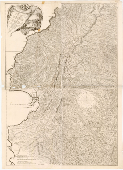
Dispossesions in the Americas

Dispossesions in the Americas

  • Home
  • Explore
  • About
  • Authors
  • Art
  • Bodies
  • Curricula
  • Cultural Heritage
  • Maps
  • Territories
Back to Explore
Map 1700 - 1799

Amérique Méridionale. Publiée sous les auspices de Monseigneur Le Duc d'Orleans.

  • Anville, Jean Baptiste d'

Published: 1748

  • Download Image

Peoples

  • ABANOS
  • ACANEJOS
  • ACHAGUAS
  • ACOQUAS
  • AMICOUANES
  • ANDAJIES
  • CABERRES
  • CAMBAS
  • CARATES
  • CARIVAS
  • CHIRICUAS
  • COCAMAS
  • CUNIVOS
  • GALIBIS
  • GUAJIROS
  • GUAJIVAS
  • GUAMALIES
  • GUAMOS
  • GUARAUNAS
  • IXINORES
  • MANAMABOBOS
  • MAYORUNAS
  • MERCIOUS
  • MOTILONES
  • NORAGUES
  • OROMIRAS
  • OTOMACAS
  • OVELLUDOS
  • PALENQUES
  • PALICOURS
  • PARAGUAS
  • PIRIOUS
  • PIROS
  • ROAMAYYNAS
  • SALIVAS
  • SARURAS
  • SUCUMBIOS
  • QUAQUAAS
  • QUIRIQUIRES
  • QUIRRUPAS
  • XIBAROS
  • ZAPARAS
  • ZENZEGUAJES
  • ZITARA

Citation

Anville, Jean Baptiste d', Atlas accompagnant le premier mémoire du Brésil. Biblioteca Nacional Digital. Accessed, August 5, 2023. bndigital.bnportugal.gov.pt/idviewer/14413/37 bndigital.bnportugal.gov.pt/idviewer/14413/37

  • Download Image

Reading in Spanish

Map 1700 - 1799

Amérique Méridionale. Publiée sous les auspices de Monseigneur Le Duc d'Orleans.

  • Anville, Jean Baptiste d'

Published: 1748

  • Download Image
  • Download Image

Related Content

Localización del área del Gran Chaco, Argentina  (adaptado de Museo del libro y de la lengua 2012)

Localización del área del Gran Chaco, Argentina (adaptado de Museo del libro y de la lengua 2012)

Map 2012
DESCRIPCIÓN GEOGRÁFICA DEL RIO MAMORE O MADERA EN LA AMERICA AUSTRAL DEL DOMINIO DE LA CORONA ESPAÑOLA

DESCRIPCIÓN GEOGRÁFICA DEL RIO MAMORE O MADERA EN LA AMERICA AUSTRAL DEL DOMINIO DE LA CORONA ESPAÑOLA

Map 1782
ATLAS de VENEZUELA ESTADO ZULIA

ATLAS de VENEZUELA ESTADO ZULIA

Map 1916
REGIÓN SELVA LACANDONA

REGIÓN SELVA LACANDONA

Map 2000
XI RONDA PETROLERA Y TERRITORIOS INDIGENAS

XI RONDA PETROLERA Y TERRITORIOS INDIGENAS

Map 2011
Geographical Distribution of the Huave

Geographical Distribution of the Huave

Map 1969
Carte du gouvernement de lisle et terre ferme de Caienne France equinoxial.

Carte du gouvernement de lisle et terre ferme de Caienne France equinoxial.

Map 1724
A Map of part of Yucatan or of that Part of the Eastern Shore Within the Bay of Honduras Alloted to Great Britain for the Cutting of Logwood, in consequence of the Convention Signed with Spain on the 14th July 1786.

A Map of part of Yucatan or of that Part of the Eastern Shore Within the Bay of Honduras Alloted to Great Britain for the Cutting of Logwood, in consequence of the Convention Signed with Spain on the 14th July 1786.

Map 1700

Dispossessions in the Americas

A project by

University of Pennsylvania

Copyright 2024

With support from

Mellon Foundation

Site design & development

Element 84

Art Credits

Anville, Jean Baptiste d’, Atlas accompagnant le premier mémoire du Brésil. Biblioteca Nacional Digital. Accessed, August 5, 2023. bndigital.bnportugal.gov.pt/idviewer/14413/37 bndigital.bnportugal.gov.pt/idviewer/14413/37

Site Pages

  • Home
  • Explore
  • About
  • Authors
  • Art
  • Bodies
  • Curricula
  • Cultural Heritage
  • Maps
  • Territories