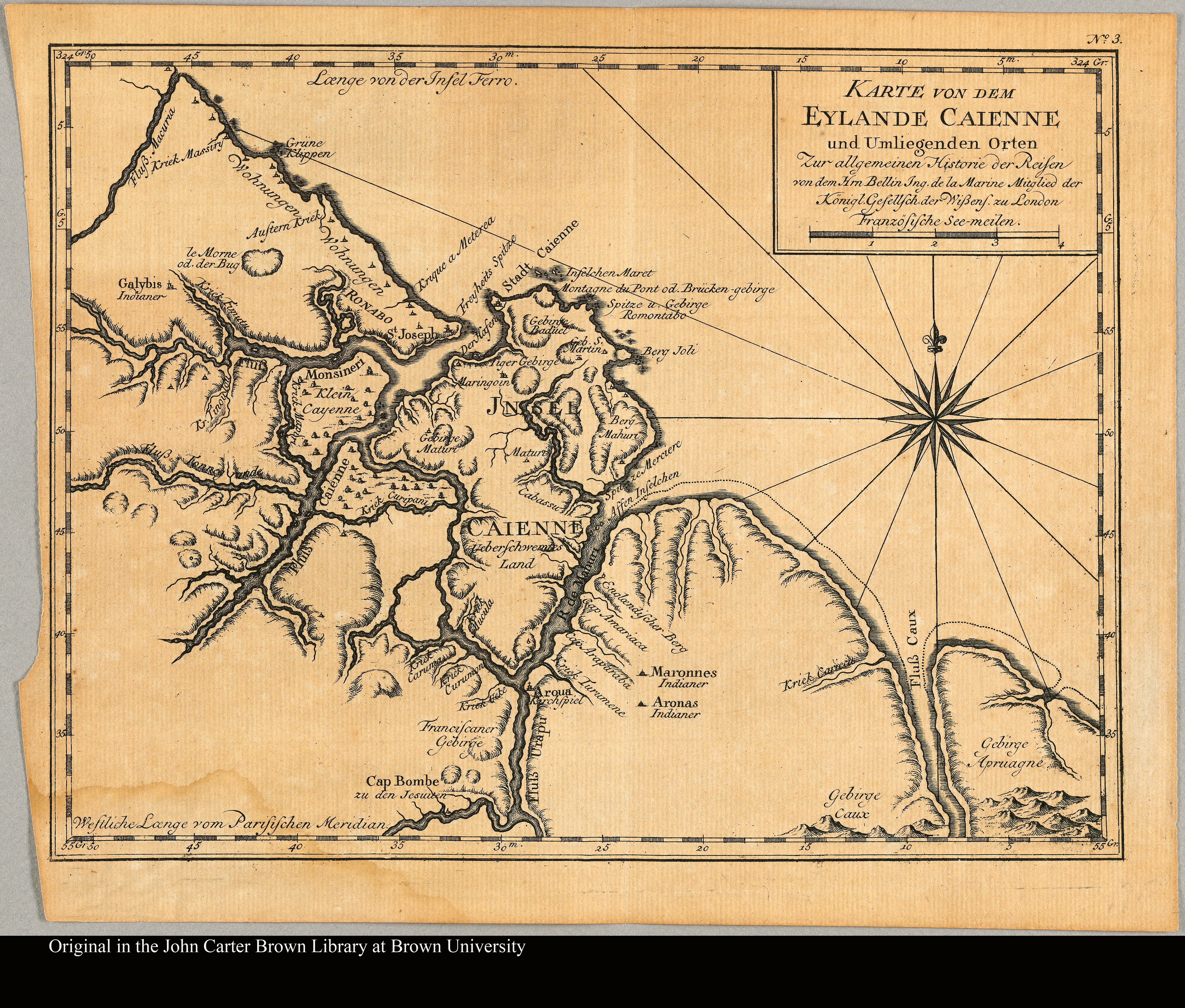
Dispossesions in the Americas

Dispossesions in the Americas

  • Home
  • Explore
  • About
  • Authors
  • Art
  • Bodies
  • Curricula
  • Cultural Heritage
  • Maps
  • Territories
Back to Explore
Map 1800 - 1899

Outlines of the physical and political division of South America: Delineated by A. Arrowsmith partly from scarce and original documents, published before the year 1806 but principally from manuscript maps & surveys made between the years 1771 and 1806, corrected from accurate astronomical observations to 1810.

  • Arrowsmith, Aaron

Published: 1810

  • Download Image

Peoples

  • ABACACHIS
  • ACOQUAS
  • AMICOUANES
  • ANDIRASES
  • APAMAS
  • ARAPIYUS
  • ARARAS
  • ARINACOTOS
  • ARINOS
  • ARITUS
  • ARMABOUTOUS
  • ARUACAS
  • ATURAYOS
  • CARPINAS
  • CNDURISES
  • COPARIPUCUS
  • COUSSARIS
  • ENGAYABAS
  • GALIBIS
  • GUACANAYAS
  • KIRIKIRISCOTAS
  • MACUSIS
  • MAGUES
  • MAMAYANASES
  • MARAYUS
  • MAYEZ
  • PACAJAS
  • PALICOURS
  • PARABAYAS
  • PARAGUANAS
  • PIRIOUS
  • QUIMAUS
  • SAMUNDASES
  • TACUANHAS
  • TARUMAS
  • TOPINAMBAS
  • TUCAHUNOS
  • URUBAQUIS
  • YURUNAS

Citation

Arrowsmith, Aaron, South America 1. David Rumsay Map Collection. Accessed, August 4, 2023. https://www.davidrumsey.com/luna/servlet/detail/RUMSEY~8~1~26064~1110385:South-America-1-

  • Download Image

Reading in Spanish

Map 1800 - 1899

Outlines of the physical and political division of South America: Delineated by A. Arrowsmith partly from scarce and original documents, published before the year 1806 but principally from manuscript maps & surveys made between the years 1771 and 1806, corrected from accurate astronomical observations to 1810.

  • Arrowsmith, Aaron

Published: 1810

  • Download Image
  • Download Image

Related Content

PUEBLO YAGUA

PUEBLO YAGUA

Map 2021
Indigenous territories and Bosawás in Nicaragua.

Indigenous territories and Bosawás in Nicaragua.

Map 2000
APPROXIMATE BORDERS OF TERRITORY OF THE AYMARA POLITY KARANQAS (OR CARANGAS) IN THE 19TH CENTURY

APPROXIMATE BORDERS OF TERRITORY OF THE AYMARA POLITY KARANQAS (OR CARANGAS) IN THE 19TH CENTURY

Map 1894
Map of deforestation within protected areas in Guatemala and adjoining areas

Map of deforestation within protected areas in Guatemala and adjoining areas

Map 2000 - 2100
Cours de l’Orenoque Depuis ses sources jusqu'à la Mer Avec les Rivieres qui s'y déchargent

Cours de l’Orenoque Depuis ses sources jusqu'à la Mer Avec les Rivieres qui s'y déchargent

Map 1764
AMÉRICA MERIDIONAL : BIBLIOTECA ESPAÑA

AMÉRICA MERIDIONAL : BIBLIOTECA ESPAÑA

Map 1662 - 1791
Lienzo de Quauhquechollan

Lienzo de Quauhquechollan

Map 1527 - 1529
Población yoeme (yaqui) en 2010

Población yoeme (yaqui) en 2010

Map 2010

Dispossessions in the Americas

A project by

University of Pennsylvania

Copyright 2024

With support from

Mellon Foundation

Site design & development

Element 84

Art Credits

Arrowsmith, Aaron, South America 1. David Rumsay Map Collection. Accessed, August 4, 2023. https://www.davidrumsey.com/luna/servlet/detail/RUMSEY~8~1~26064~1110385:South-America-1-

Site Pages

  • Home
  • Explore
  • About
  • Authors
  • Art
  • Bodies
  • Curricula
  • Cultural Heritage
  • Maps
  • Territories