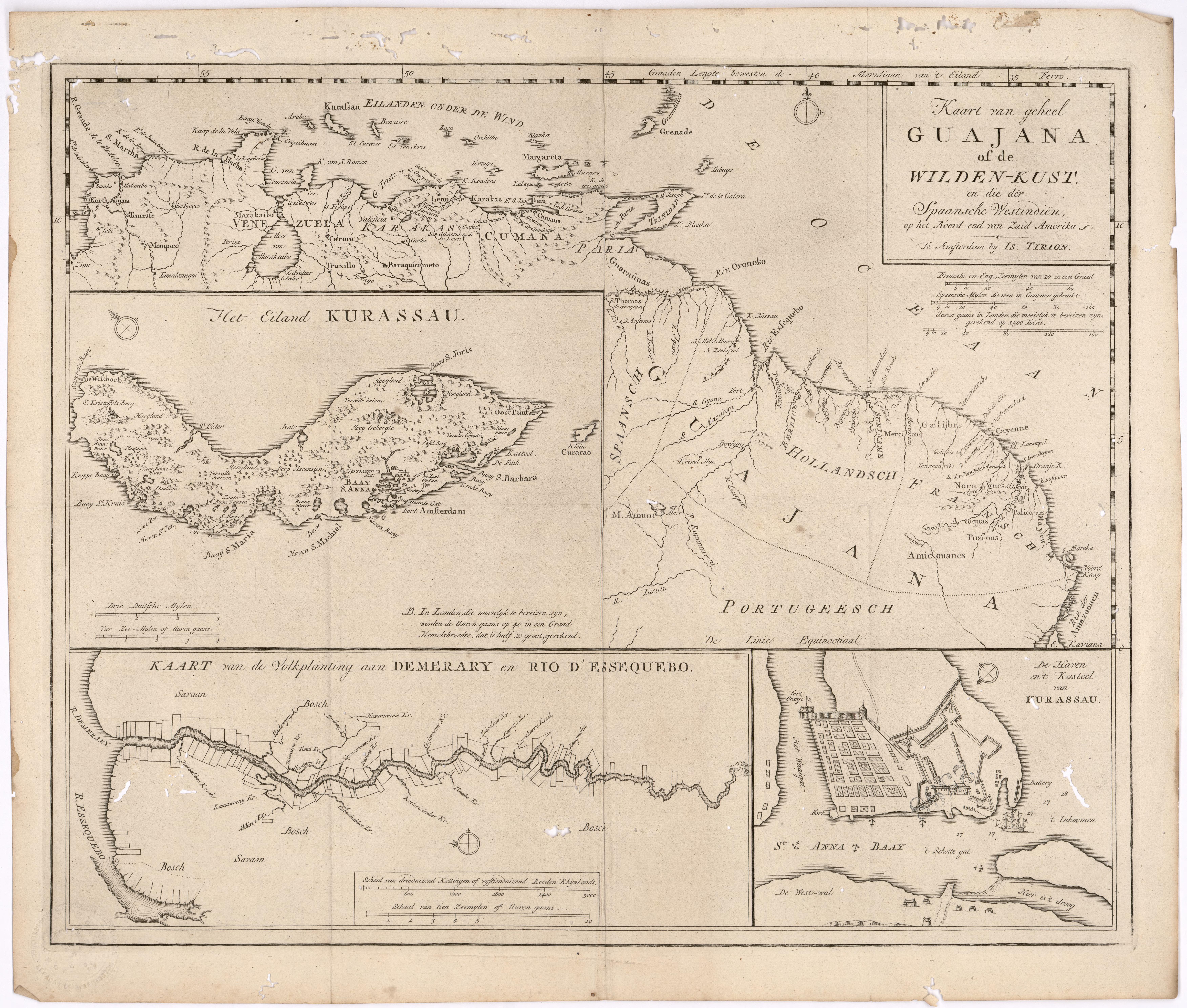
Dispossesions in the Americas

Dispossesions in the Americas

  • Home
  • Explore
  • About
  • Authors
  • Art
  • Bodies
  • Curricula
  • Cultural Heritage
  • Maps
  • Territories
Back to Explore
Map 1700 - 1799

Kart van geheel Guajana of de Wilden-Kust

  • Tirion, Isaak

Published: 1720

  • Download Image

Peoples

  • ACOQUAS
  • AMICOUANES
  • GALIBIS
  • GUARAUNAS
  • MAYEZ
  • NORAGUES
  • PALICOURS
  • PIRIOUS

Citation

Tirion, Isaak. Map of the Whole of Guiana or the Savage Coast, and the Spanish West Indies at the Northern End of South America. Library of Congress. Accessed, August 3, 2023. https://www.loc.gov/resource/gdcwdl.wdl_11339/?r=0.213,0.044,0.861,0.453,0

  • Download Image

Reading in Spanish

Map 1700 - 1799

Kart van geheel Guajana of de Wilden-Kust

  • Tirion, Isaak

Published: 1720

  • Download Image
  • Download Image

Reading in Portuguese

Map 1700 - 1799

Kart van geheel Guajana of de Wilden-Kust

  • Tirion, Isaak

Published: 1720

  • Download Image

Peoples

  • ACOQUAS
  • AMICOUANES
  • GALIBIS
  • GUARAUNAS
  • MAYEZ
  • NORAGUES
  • PALICOURS
  • PIRIOUS

Citation

Tirion, Isaak. Map of the Whole of Guiana or the Savage Coast, and the Spanish West Indies at the Northern End of South America. Library of Congress. Accessed, August 3, 2023. https://www.loc.gov/resource/gdcwdl.wdl_11339/?r=0.213,0.044,0.861,0.453,0

  • Download Image

Related Content

La Gaîté Parisienne [The Parisian Joy Series]

La Gaîté Parisienne [The Parisian Joy Series]

Artwork
SONORA

SONORA

Map 2015
San Roman and Santa Rosa

San Roman and Santa Rosa

Map 1997
Lacandon Settlements in Eastern Chiapas

Lacandon Settlements in Eastern Chiapas

Map 1969
AMERICA KARATE VON LAUFE DES ORENOCO DES ATABAPO DES CASIQUIARE UND DES RIO NEGRO

AMERICA KARATE VON LAUFE DES ORENOCO DES ATABAPO DES CASIQUIARE UND DES RIO NEGRO

Map 1850
Mapa Corografico De la Provincia de Sta. Marta y parte de las de Cartagena de Yndias, Giron, Pamplona, Maracaybo, Y Rio del Hacha sus confinante

Mapa Corografico De la Provincia de Sta. Marta y parte de las de Cartagena de Yndias, Giron, Pamplona, Maracaybo, Y Rio del Hacha sus confinante

Map 1811
COLUMBIA

COLUMBIA

Map 1829
Carte de la Guyane française (2ème édition). Service géographique des colonies. [Feuille 2]

Carte de la Guyane française (2ème édition). Service géographique des colonies. [Feuille 2]

Map 1926

Dispossessions in the Americas

A project by

University of Pennsylvania

Copyright 2024

With support from

Mellon Foundation

Site design & development

Element 84

Art Credits

Tirion, Isaak. Map of the Whole of Guiana or the Savage Coast, and the Spanish West Indies at the Northern End of South America. Library of Congress. Accessed, August 3, 2023. https://www.loc.gov/resource/gdcwdl.wdl_11339/?r=0.213,0.044,0.861,0.453,0

Site Pages

  • Home
  • Explore
  • About
  • Authors
  • Art
  • Bodies
  • Curricula
  • Cultural Heritage
  • Maps
  • Territories