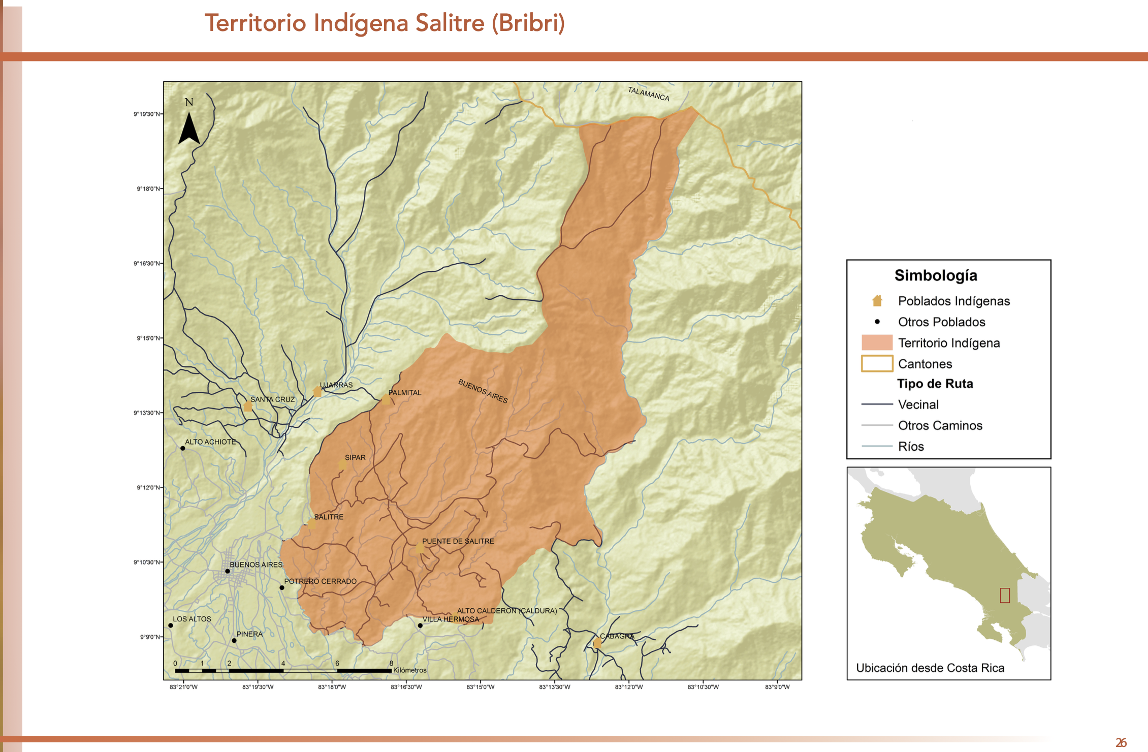
Dispossesions in the Americas

Dispossesions in the Americas

  • Home
  • Explore
  • About
  • Authors
  • Art
  • Bodies
  • Curricula
  • Cultural Heritage
  • Maps
  • Territories
Back to Explore
Map 1700 - 1799

[Carte de la Guyane, des bassins de l'Orénoque et de l'Amazone]

    Published: 1750

    • Download Image

    Peoples

    • ABACARUAS
    • AMOIZANNAS
    • ARINACOTOS
    • AROAQUIS
    • ATURES
    • AVINABIS
    • CABERES
    • CACAGUALES
    • CARIANA
    • CARIBES
    • CARIGUANAS
    • CUCHIVARAS
    • CUSSARIS
    • ENGAYABAS
    • IVARINA
    • JAMUNDASES
    • MAJANAS
    • MANUS
    • MARAGUASES
    • MARIPISANAS
    • MAQUIRITARI
    • MAYES
    • MURAS
    • OCOMESIANAS
    • OMAGUAS
    • PARAGUANAS
    • PARAVENAS
    • TAPAYOSOS
    • TARUMAS
    • UPISANA
    • UMAREBITANNAS
    • URUBAQUIS
    • YAVEIS

    Citation

    [Carte de la Guyane, des bassins de l'Orénoque et de l'Amazone]. Gallica. Last modified: September 19, 2016. Accessed, July 29, 2023. https://gallica.bnf.fr/ark:/12148/btv1b531230758

    • Download Image

    Reading in Spanish

    Map 1700 - 1799

    [Carte de la Guyane, des bassins de l'Orénoque et de l'Amazone]

      Published: 1750

      • Download Image
      • Download Image

      Reading in Portuguese

      Map 1700 - 1799

      [Carte de la Guyane, des bassins de l'Orénoque et de l'Amazone]

        Published: 1750

        • Download Image

        Peoples

        • ABACARUAS
        • AMOIZANNAS
        • ARINACOTOS
        • AROAQUIS
        • ATURES
        • AVINABIS
        • CABERES
        • CACAGUALES
        • CARIANA
        • CARIBES
        • CARIGUANAS
        • CUCHIVARAS
        • CUSSARIS
        • ENGAYABAS
        • IVARINA
        • JAMUNDASES
        • MAJANAS
        • MANUS
        • MARAGUASES
        • MARIPISANAS
        • MAQUIRITARI
        • MAYES
        • MURAS
        • OCOMESIANAS
        • OMAGUAS
        • PARAGUANAS
        • PARAVENAS
        • TAPAYOSOS
        • TARUMAS
        • UPISANA
        • UMAREBITANNAS
        • URUBAQUIS
        • YAVEIS

        Citation

        [Carte de la Guyane, des bassins de l'Orénoque et de l'Amazone]. Gallica. Last modified: September 19, 2016. Accessed, July 29, 2023. https://gallica.bnf.fr/ark:/12148/btv1b531230758

        • Download Image

        Related Content

        DISTRIBUCION DE GRUPOS CON LENGUAS CHIBCHAS

        DISTRIBUCION DE GRUPOS CON LENGUAS CHIBCHAS

        Map 2019
        Ethnographische Karte von Guatemala

        Ethnographische Karte von Guatemala

        Map 1884
        Guide map of the tribes and subjects of Volume 1 of the Handbook

        Guide map of the tribes and subjects of Volume 1 of the Handbook

        Map
        PUEBLO CHINANTECO

        PUEBLO CHINANTECO

        Map 2020
        "Territorio Indígena Salitre (Bribri)"

        "Territorio Indígena Salitre (Bribri)"

        Map 2010
        Gulf of Amapall

        Gulf of Amapall

        Map 1683 - 1685
        Mapa de la Provincia de Chiloé en el Reino de Chile y
     el número de sus habitantes

        Mapa de la Provincia de Chiloé en el Reino de Chile y el número de sus habitantes

        Map 1785
        NACIONALIDADES INDÍGENAS DEL ECUADOR

        NACIONALIDADES INDÍGENAS DEL ECUADOR

        Map 1988

        Dispossessions in the Americas

        A project by

        University of Pennsylvania

        Copyright 2024

        With support from

        Mellon Foundation

        Site design & development

        Element 84

        Art Credits

        [Carte de la Guyane, des bassins de l’Orénoque et de l’Amazone]. Gallica. Last modified: September 19, 2016. Accessed, July 29, 2023. https://gallica.bnf.fr/ark:/12148/btv1b531230758

        Site Pages

        • Home
        • Explore
        • About
        • Authors
        • Art
        • Bodies
        • Curricula
        • Cultural Heritage
        • Maps
        • Territories