Dispossesions in the Americas

Dispossesions in the Americas

  • Home
  • Explore
  • About
  • Authors
  • Art
  • Bodies
  • Curricula
  • Cultural Heritage
  • Maps
  • Territories
Back to Explore
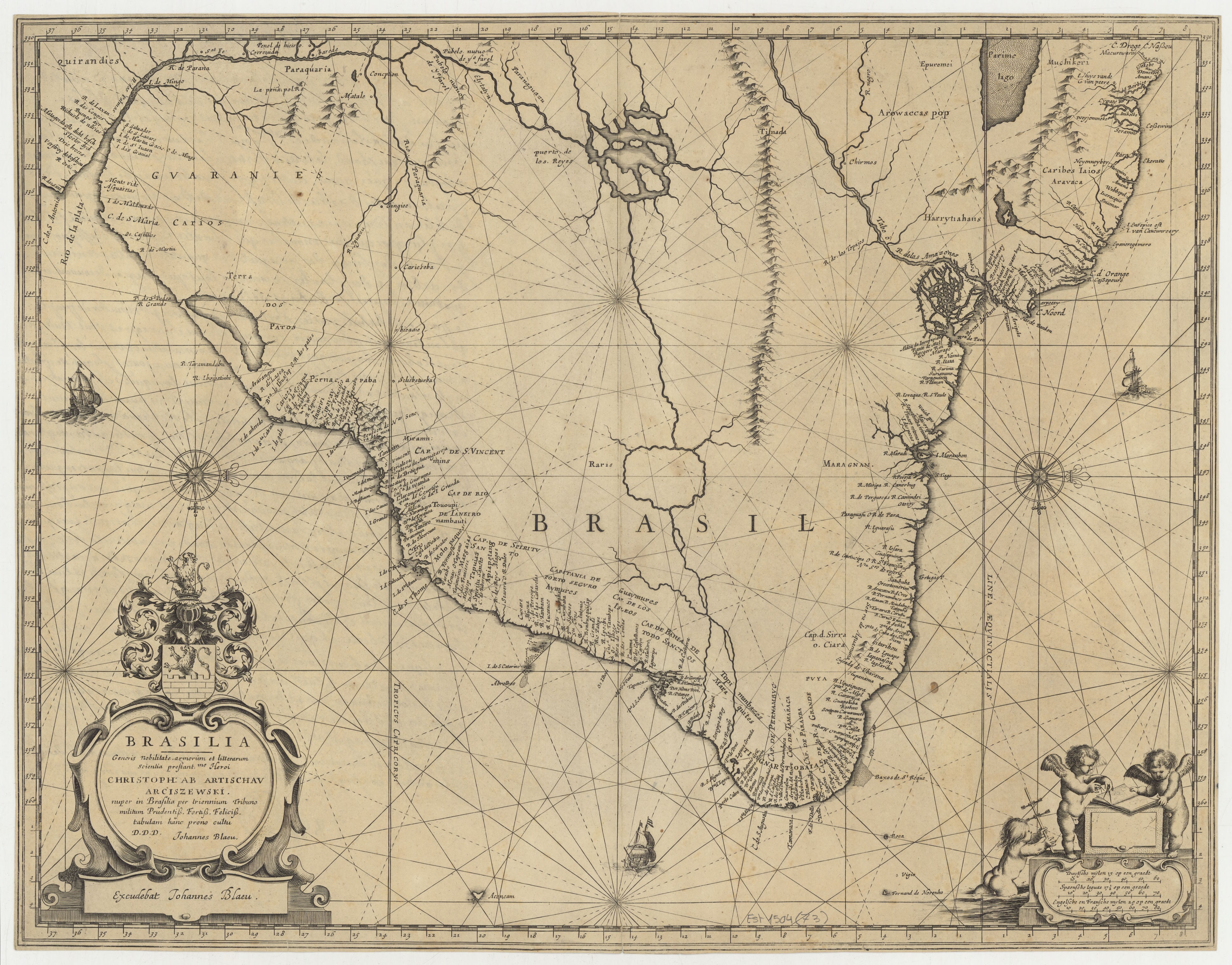
Map 1662 - 1665

BRASILIA

  • BLAEU, JOHANNES

Published: 1673

  • Download Image

Peoples

  • MUCHIKERI
  • ARAVACA
  • CARIBES
  • EPUREMEI
  • AROWACCAS
  • HARRYTIAHANS
  • QUIRANDIES
  • GUARANIES
  • CARIOS
  • CARIOES
  • ANNIRIRI
  • CIPOYAY
  • TOUOUPINAMBAUTI
  • MOLOPAQUES
  • MARGAIAS
  • TAPUIAS
  • APIAPETANG
  • AYMURES
  • GUAYMURES
  • MARAQUITES
  • TOPIMANBAZES
  • KITARIHOU
  • CLAPEPOURI
  • CARABUNI
  • ARIKARI

Citation

Blaeu, Johannes. Brasilia. Map. Amsterdam: Johannes Blaeu, 1673. Accessed July 23, 2023. https://gallica.bnf.fr/ark:/12148/btv1b53177824q/f1.item.
  • Download Image

Reading in Spanish

Map 1662 - 1665

BRASILIA

  • BLAEU, JOHANNES

Published: 1673

  • Download Image
  • Download Image

Related Content

The Fort Yuma Reservation and Places Mentioned in the Text

The Fort Yuma Reservation and Places Mentioned in the Text

Map 2016
Carte du gouvernement de l'Isle et terre ferme de Cayenne a L'Amerique / fait au dit lieu par le Sr. H.D.M.C.

Carte du gouvernement de l'Isle et terre ferme de Cayenne a L'Amerique / fait au dit lieu par le Sr. H.D.M.C.

Map 1724
Santa Teresa

Santa Teresa

Map 1997
PUEBLO PA IPAI

PUEBLO PA IPAI

Map 2020
TERRITORIO DEL SEÑORÍO AYMARA DE LOS QARAQARA EN EL SIGLO XVI

TERRITORIO DEL SEÑORÍO AYMARA DE LOS QARAQARA EN EL SIGLO XVI

Map 1530
GEOGRAPHISCHE KARTE DER PROVINZ VON SÃO JOZÉ DO PIAUHY. Carte Géographique de PIAUHY, Province de l'Empire du Brésil

GEOGRAPHISCHE KARTE DER PROVINZ VON SÃO JOZÉ DO PIAUHY. Carte Géographique de PIAUHY, Province de l'Empire du Brésil

Map 1828
Location of three ethno-linguistic groups in the highlands of Guatemala in which joint InHerit-Riecken community-participant mapping took place. Adapted from http://d-maps. com/carte.php?num_car=1717&lang=en)

Location of three ethno-linguistic groups in the highlands of Guatemala in which joint InHerit-Riecken community-participant mapping took place. Adapted from http://d-maps. com/carte.php?num_car=1717&lang=en)

Map 2000
PART OF A MAP OF SOUTH AMERICA BY JOHN ARROWSMITH;1840;BEING A REVISED EDITION OF A MAP FIRST PUBLISHED BY AARON ARROWSMITH

PART OF A MAP OF SOUTH AMERICA BY JOHN ARROWSMITH;1840;BEING A REVISED EDITION OF A MAP FIRST PUBLISHED BY AARON ARROWSMITH

Map 1840

Dispossessions in the Americas

A project by

University of Pennsylvania

Copyright 2024

With support from

Mellon Foundation

Site design & development

Element 84

Art Credits

Blaeu, Johannes. Brasilia. Map. Amsterdam: Johannes Blaeu, 1673. Accessed July 23, 2023. https://gallica.bnf.fr/ark:/12148/btv1b53177824q/f1.item.
Site Pages

  • Home
  • Explore
  • About
  • Authors
  • Art
  • Bodies
  • Curricula
  • Cultural Heritage
  • Maps
  • Territories