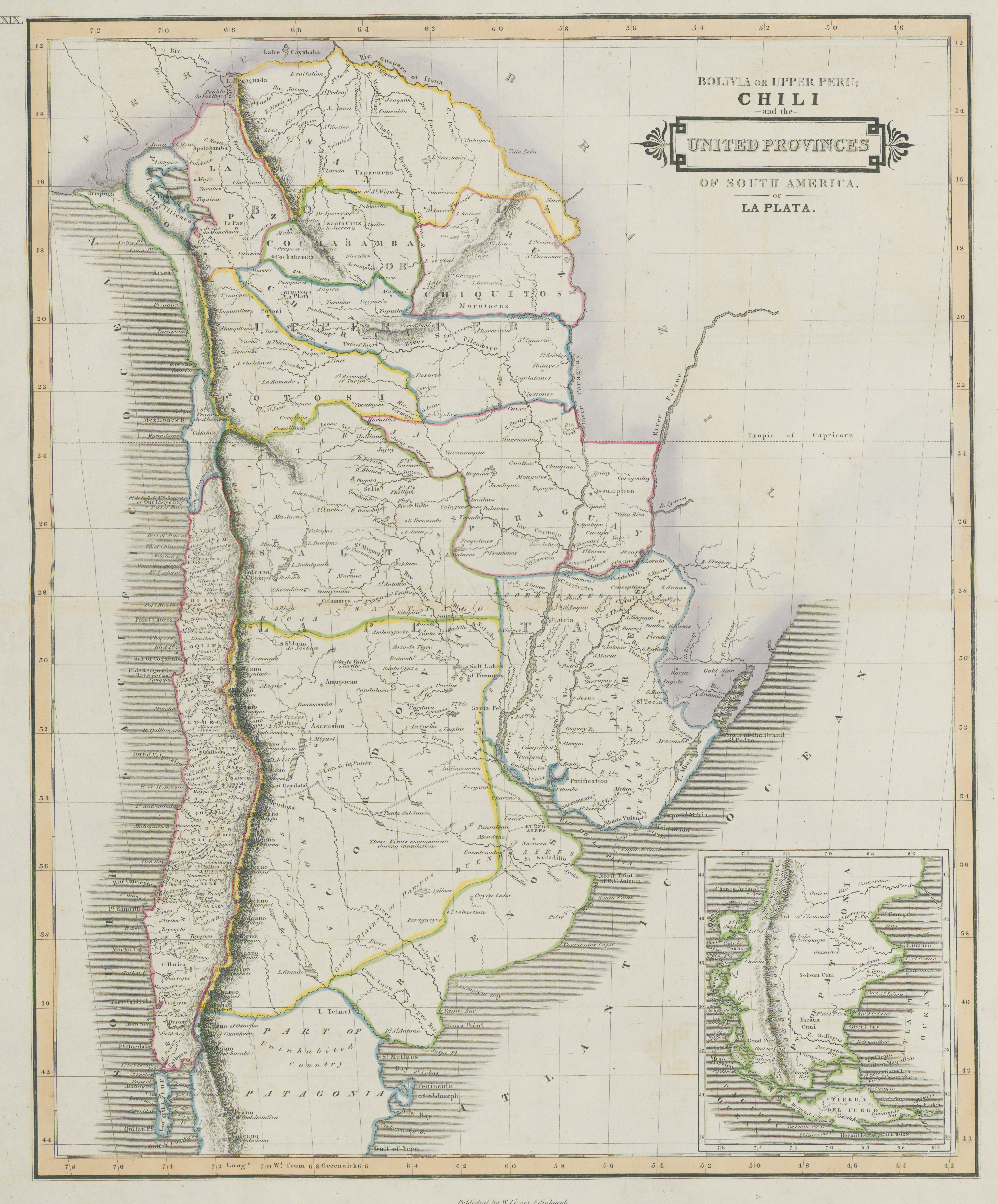
Dispossesions in the Americas

Dispossesions in the Americas

  • Home
  • Explore
  • About
  • Authors
  • Art
  • Bodies
  • Curricula
  • Cultural Heritage
  • Maps
  • Territories
Back to Explore
Map 1800 - 1850

Bolivia Or Upper Peru;Chili and the United Provinces Of South America, or La Plata

  • LIZARS, WILLIAM

Published: 1836

  • Download Image

Peoples

  • PEHUENCHES
  • TAPICURAS
  • MOROROCOS
  • YACANA CUNI

Citation

Lizars, William. Bolivia Or Upper Peru, Chili and the United Provinces Of South America, or La Plata. Map. Edimburgh, Scotland: W. Lizars, 1836. Accessed July 9, 2023. https://digital.iai.spk-berlin.de/viewer/image/630121303/1/LOG_0000/.

  • Download Image

Reading in Spanish

Map 1800 - 1850

Bolivia Or Upper Peru;Chili and the United Provinces Of South America, or La Plata

  • LIZARS, WILLIAM

Published: 1836

  • Download Image
  • Download Image

Reading in Portuguese

Map 1800 - 1850

Bolivia Or Upper Peru;Chili and the United Provinces Of South America, or La Plata

  • LIZARS, WILLIAM

Published: 1836

  • Download Image

Peoples

  • PEHUENCHES
  • TAPICURAS
  • MOROROCOS
  • YACANA CUNI

Citation

Lizars, William. Bolivia Or Upper Peru, Chili and the United Provinces Of South America, or La Plata. Map. Edimburgh, Scotland: W. Lizars, 1836. Accessed July 9, 2023. https://digital.iai.spk-berlin.de/viewer/image/630121303/1/LOG_0000/.

  • Download Image

Related Content

Ritxoko / Boneca karajá

Ritxoko / Boneca karajá

Artwork
PUEBLO NAHUA DE MORELOS

PUEBLO NAHUA DE MORELOS

Map 2020
[Carte de la Guyane, des bassins de l'Orénoque et de l'Amazone]

[Carte de la Guyane, des bassins de l'Orénoque et de l'Amazone]

Map 1700 - 1799
PUEBLO POPOLUCA DE LA SIERRA

PUEBLO POPOLUCA DE LA SIERRA

Map 2020
Carte de l'entrée de la Rivière de Kourou.

Carte de l'entrée de la Rivière de Kourou.

Map 1764
La sirena del Ucayali [The Ucayali Mermaid]

La sirena del Ucayali [The Ucayali Mermaid]

Artwork
Mapa de la costa de la provincia de [Santa Marta con las bahías], Rios y Sitios

Mapa de la costa de la provincia de [Santa Marta con las bahías], Rios y Sitios

Map 1770
Theories of Migration (Charrúas).

Theories of Migration (Charrúas).

Map 1680 - 1805

Dispossessions in the Americas

A project by

University of Pennsylvania

Copyright 2024

With support from

Mellon Foundation

Site design & development

Element 84

Art Credits

Lizars, William. Bolivia Or Upper Peru, Chili and the United Provinces Of South America, or La Plata. Map. Edimburgh, Scotland: W. Lizars, 1836. Accessed July 9, 2023. https://digital.iai.spk-berlin.de/viewer/image/630121303/1/LOG_0000/.

Site Pages

  • Home
  • Explore
  • About
  • Authors
  • Art
  • Bodies
  • Curricula
  • Cultural Heritage
  • Maps
  • Territories