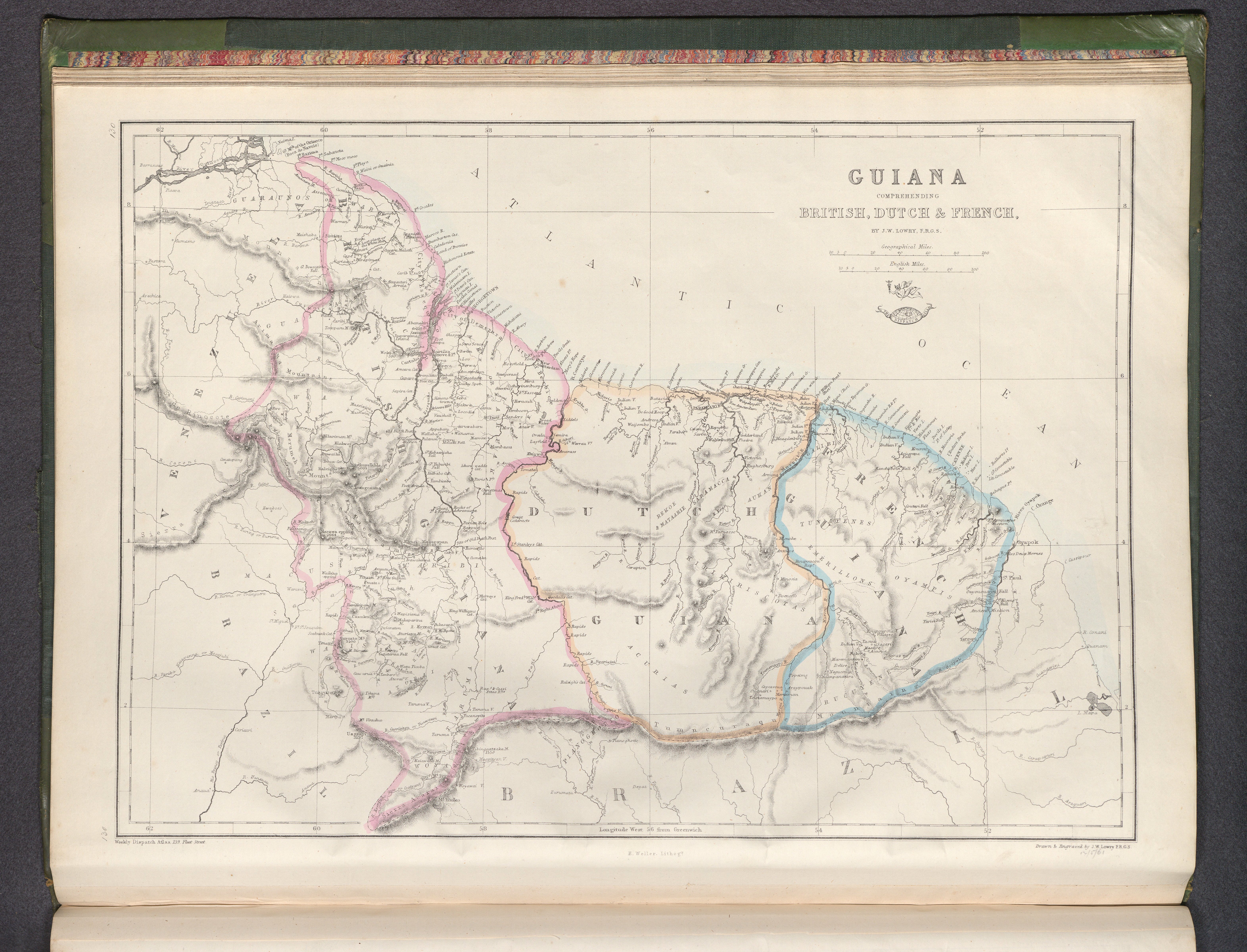
Dispossesions in the Americas

Dispossesions in the Americas

  • Home
  • Explore
  • About
  • Authors
  • Art
  • Bodies
  • Curricula
  • Cultural Heritage
  • Maps
  • Territories
Back to Explore
Map 1800 - 1899

Guiana, comprehending British, Dutch & French

  • Lowry, Joseph Wilson,

Published: 1863

  • Download Image

Peoples

  • ACURIAS
  • AUKAN
  • ARUAKA
  • ATOBAI
  • CARIBI
  • EMERILLONS
  • GALIBIS
  • GUAICA
  • GUARUNOS
  • KIRIKIRISCOTAS
  • MACUSI
  • OYAMPIS
  • PIANOGHOTTOWAICA
  • RUCUYENES
  • SARAMACCA
  • TUNAYENES
  • WAPISIANA
  • WARRAUWOYAWAI

Citation

Lowry, Joseph Wilson, Guiana, comprehending British, Dutch & French. David Rumsey Map Collection. Accessed: July 4, 2023. https://www.davidrumsey.com/luna/servlet/detail/RUMSEY~8~1~343750~90111648:Guiana,-comprehending-British,-Dutc

  • Download Image

Reading in Spanish

Map 1800 - 1899

Guiana, comprehending British, Dutch & French

  • Lowry, Joseph Wilson,

Published: 1863

  • Download Image
  • Download Image

Related Content

DIE EHEMALIGE VERBREITUNG und die MUTHMASSLICHEN WANDERUNGEN der TUPIS. Die jetzigen HAUPT-SPRACHENGRUPPEN.

DIE EHEMALIGE VERBREITUNG und die MUTHMASSLICHEN WANDERUNGEN der TUPIS. Die jetzigen HAUPT-SPRACHENGRUPPEN.

Map 1875
Karte von dem Eylande Caienne und Umliegenden Orten Zur allgemeinen Histoire der Reisen

Karte von dem Eylande Caienne und Umliegenden Orten Zur allgemeinen Histoire der Reisen

Map 1757
Map of Nicaragua showing Ulwa settlements in Eastern Nicaragua and field study sites (in rectangle)

Map of Nicaragua showing Ulwa settlements in Eastern Nicaragua and field study sites (in rectangle)

Map 1990
BAJA CALIFORNIA

BAJA CALIFORNIA

Map 2015
La región litoral ecuatoriana

La región litoral ecuatoriana

Map -500 - 1551
Carta plana de la provincia de La Hacha situada entre las de Santa Marta y Maracaybo

Carta plana de la provincia de La Hacha situada entre las de Santa Marta y Maracaybo

Map 1786
Silver Creek

Silver Creek

Map 1997
Descripción geográfica (mapa que comprehende la visita practicada por el Sr. Doctor Don Francisco Antonio Moreno y Escandon;Fiscal del Crimen en la Real Audiencia de Santa Fé de Bogotá. 1781 A consequencia de Real Cédula fecha á tres de Agosto de 1774

Descripción geográfica (mapa que comprehende la visita practicada por el Sr. Doctor Don Francisco Antonio Moreno y Escandon;Fiscal del Crimen en la Real Audiencia de Santa Fé de Bogotá. 1781 A consequencia de Real Cédula fecha á tres de Agosto de 1774

Map 1781

Dispossessions in the Americas

A project by

University of Pennsylvania

Copyright 2024

With support from

Mellon Foundation

Site design & development

Element 84

Art Credits

Lowry, Joseph Wilson, Guiana, comprehending British, Dutch & French. David Rumsey Map Collection. Accessed: July 4, 2023. https://www.davidrumsey.com/luna/servlet/detail/RUMSEY~8~1~343750~90111648:Guiana,-comprehending-British,-Dutc

Site Pages

  • Home
  • Explore
  • About
  • Authors
  • Art
  • Bodies
  • Curricula
  • Cultural Heritage
  • Maps
  • Territories