Dispossesions in the Americas

Dispossesions in the Americas

  • Home
  • Explore
  • About
  • Authors
  • Art
  • Bodies
  • Curricula
  • Cultural Heritage
  • Maps
  • Territories
Back to Explore
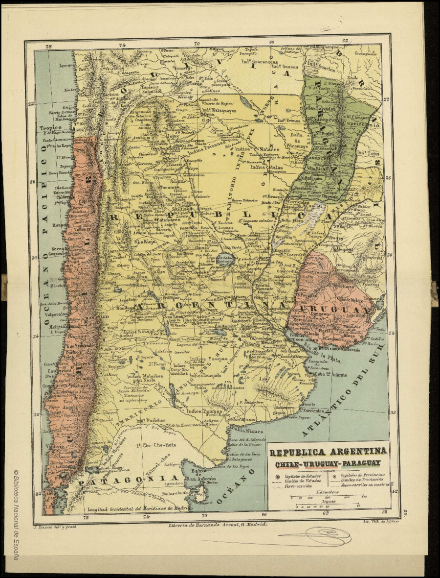
Map 1884

REPUBLICA ARGENTINA CHILE-URUGUAY-PARAGUAY

  • REINOSO;JOSE

Published: 1884

  • Download Image

Peoples

  • GUARANOCA
  • GUANA
  • GUACHIS
  • PAI TAVYTERA
  • ERIMAS
  • MATACO
  • ATALALA
  • TUPY
  • PAISANAS
  • COLUQUEOCHES
  • RANQUELS
  • PAMPAS
  • CURA-MA-MUELCHES
  • RANQUIL-CHES
  • MOLUCHES DEL NORTE
  • PUANMAPO-CHES
  • POYU-CHES
  • HUILI PAUVOS
  • PUELCHES
  • CHE-CHE-HETS
  • TECHUEL-CHES

Citation

Reinoso, José. "República Argentina Chile-Uruguay-Paraguay." Map. In Atlas Geográfico Universal en veinte mapas arreglados al meridiano del Madrid, 44. Madrid: Imprenta y Libreria de D.G. Hernando, 1884. Accessed April 26, 2023. http://bdh-rd.bne.es/viewer.vm?id=0000001196.
  • Download Image

Reading in Spanish

Map 1884

REPUBLICA ARGENTINA CHILE-URUGUAY-PARAGUAY

  • REINOSO;JOSE

Published: 1884

  • Download Image
  • Download Image

Related Content

Mapa de diversidad étnica

Mapa de diversidad étnica

Map 2012
Geographic Distribution of Huichol and Cora, Showing State Names

Geographic Distribution of Huichol and Cora, Showing State Names

Map 1969
Carta para la inteligencia del informe sobre fronteras presentado al Excelentísimo Gobierno nacional por el General Don Wenceslao Paunero. Impreso

Carta para la inteligencia del informe sobre fronteras presentado al Excelentísimo Gobierno nacional por el General Don Wenceslao Paunero. Impreso

Map 1850 - 1880
SUITE DU BRESIL depuis la Baye de Tous les Saints jusqu’a St. Paul

SUITE DU BRESIL depuis la Baye de Tous les Saints jusqu’a St. Paul

Map 1700 - 1750
FAMILIAS LINGUÍSTICAS Y LENGUAS INDÍGENAS. OCTAVA REGION: PENINSULA DE LA GUAJIRA

FAMILIAS LINGUÍSTICAS Y LENGUAS INDÍGENAS. OCTAVA REGION: PENINSULA DE LA GUAJIRA

Map 1989
Colombia Prima or South America drawn from the large map in eight sheets by Louis Stanislas D'Arcy Delarochette

Colombia Prima or South America drawn from the large map in eight sheets by Louis Stanislas D'Arcy Delarochette

Map 1811
La France Antarctique autrement le Rio de Janeiro

La France Antarctique autrement le Rio de Janeiro

Map 1557 - 1558
NÚMERO DE INDIOS EN LAS SUBDELEGACIONES EN 1800

NÚMERO DE INDIOS EN LAS SUBDELEGACIONES EN 1800

Map 1800

Dispossessions in the Americas

A project by

University of Pennsylvania

Copyright 2024

With support from

Mellon Foundation

Site design & development

Element 84

Art Credits

Reinoso, José. “República Argentina Chile-Uruguay-Paraguay.” Map. In Atlas Geográfico Universal en veinte mapas arreglados al meridiano del Madrid, 44. Madrid: Imprenta y Libreria de D.G. Hernando, 1884. Accessed April 26, 2023. http://bdh-rd.bne.es/viewer.vm?id=0000001196.
Site Pages

  • Home
  • Explore
  • About
  • Authors
  • Art
  • Bodies
  • Curricula
  • Cultural Heritage
  • Maps
  • Territories