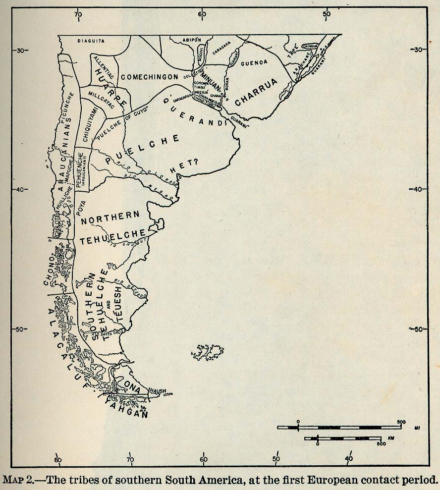
Dispossesions in the Americas

Dispossesions in the Americas

  • Home
  • Explore
  • About
  • Authors
  • Art
  • Bodies
  • Curricula
  • Cultural Heritage
  • Maps
  • Territories
Back to Explore
Map 1512

The Tribes of Southern South America;at the first European contact period

  • SMITHSONIAN INSTITUTION BUREAU OF AMERICAN ETHNOLOGY

Published: 1946

  • Download Image

Peoples

  • DIAGUITA
  • ABIPON
  • MOCOVI
  • CARACARA
  • GUARANI
  • GUENOA-MINUANES
  • CHARRUAS
  • TAPES
  • ARACHANES
  • CAINGUA
  • BOHANES
  • YAROS
  • CHANAS
  • MBEGUAES
  • TIMBU
  • COROMA
  • COLASTINES
  • CARACARANA
  • QUERANDI
  • PUELCHE
  • MILLCAYAC
  • HUARPE
  • ALLENTIAC
  • PICUNCHE
  • ARAUCANIANS
  • MAPUCHE
  • HIUILLICHE
  • CHOTE
  • CHONO
  • ALACALUF
  • YAHGAN
  • CHIQUIYAMI PEHUENCHE
  • HET
  • TEHUELCHE
  • POYA
  • TEUESH
  • ONA
  • HAUSH

Citation

Smithsonian Institution Bureau of American Ethnology. "The Tribes of Southern South America, at the first European contact period." Map. In The Marginal Tribes, edited by Julian H. Steward. Vol. 1 of Handbook of South American Indians. 1946. Accessed February 26, 2023. https://maps.lib.utexas.edu/maps/historical/south_amer_tribes_1946.jpg.

  • Download Image

Reading in Spanish

Map 1512

The Tribes of Southern South America;at the first European contact period

  • SMITHSONIAN INSTITUTION BUREAU OF AMERICAN ETHNOLOGY

Published: 1946

  • Download Image
  • Download Image

Reading in Portuguese

Map 1512

The Tribes of Southern South America;at the first European contact period

  • SMITHSONIAN INSTITUTION BUREAU OF AMERICAN ETHNOLOGY

Published: 1946

  • Download Image

Peoples

  • DIAGUITA
  • ABIPON
  • MOCOVI
  • CARACARA
  • GUARANI
  • GUENOA-MINUANES
  • CHARRUAS
  • TAPES
  • ARACHANES
  • CAINGUA
  • BOHANES
  • YAROS
  • CHANAS
  • MBEGUAES
  • TIMBU
  • COROMA
  • COLASTINES
  • CARACARANA
  • QUERANDI
  • PUELCHE
  • MILLCAYAC
  • HUARPE
  • ALLENTIAC
  • PICUNCHE
  • ARAUCANIANS
  • MAPUCHE
  • HIUILLICHE
  • CHOTE
  • CHONO
  • ALACALUF
  • YAHGAN
  • CHIQUIYAMI PEHUENCHE
  • HET
  • TEHUELCHE
  • POYA
  • TEUESH
  • ONA
  • HAUSH

Citation

Smithsonian Institution Bureau of American Ethnology. "The Tribes of Southern South America, at the first European contact period." Map. In The Marginal Tribes, edited by Julian H. Steward. Vol. 1 of Handbook of South American Indians. 1946. Accessed February 26, 2023. https://maps.lib.utexas.edu/maps/historical/south_amer_tribes_1946.jpg.

  • Download Image

Related Content

The Aboriginal Distribution of Tribes in Northwest Mexico

The Aboriginal Distribution of Tribes in Northwest Mexico

Map 1969
PUEBLO SHIPIBO-KONIBO

PUEBLO SHIPIBO-KONIBO

Map 2021
BAJA CALIFORNIA

BAJA CALIFORNIA

Map 2015
QUINTANA ROO

QUINTANA ROO

Map 2015
Población yoreme (mayo) en 2010

Población yoreme (mayo) en 2010

Map 2010
"Territorio Indígena Cabécar de Bajo Chrirripó"

"Territorio Indígena Cabécar de Bajo Chrirripó"

Map 2010
Laguna de Nicaragua

Laguna de Nicaragua

Map 1784
MICHOACÁN

MICHOACÁN

Map 2015

Dispossessions in the Americas

A project by

University of Pennsylvania

Copyright 2024

With support from

Mellon Foundation

Site design & development

Element 84

Art Credits

Smithsonian Institution Bureau of American Ethnology. “The Tribes of Southern South America, at the first European contact period.” Map. In The Marginal Tribes, edited by Julian H. Steward. Vol. 1 of Handbook of South American Indians. 1946. Accessed February 26, 2023. https://maps.lib.utexas.edu/maps/historical/south_amer_tribes_1946.jpg.

Site Pages

  • Home
  • Explore
  • About
  • Authors
  • Art
  • Bodies
  • Curricula
  • Cultural Heritage
  • Maps
  • Territories