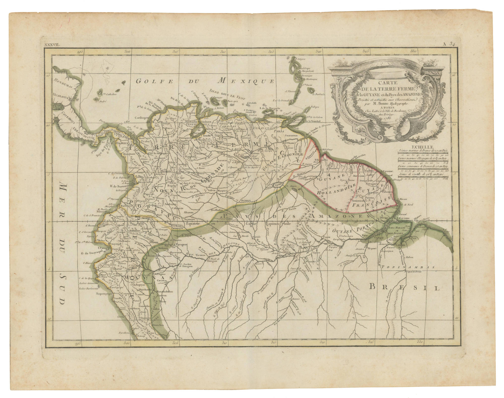
Dispossesions in the Americas

Dispossesions in the Americas

  • Home
  • Explore
  • About
  • Authors
  • Art
  • Bodies
  • Curricula
  • Cultural Heritage
  • Maps
  • Territories
Back to Explore
Map 1785

CARTE DE LA TERRE FERME de la GUYANE et du Paus des Amazones

  • BONNE;RIGOBERT

Published: 1785

  • Download Image

Peoples

  • JIRAJARA
  • ZAPARA
  • QUIRIQUIRES
  • BARI
  • SARURA
  • ARUACA
  • PAOS
  • OTOMACO
  • CARIVA
  • GUARUANA
  • MAIPURE
  • SALIVA
  • ACHAGUA
  • CABERRE
  • ANDAJIES
  • ABANOS
  • ACANEJOS
  • ORELLUDOS
  • QUAQUAS
  • URABA
  • ZITARA
  • OROMIRAS
  • EFFEQUEBE
  • GALIBIS
  • PALICOURS
  • MACAPA
  • NORAGUES
  • ACOQUAS
  • PIRIOUS
  • AMIICOUANES
  • MERCIOUS
  • SACUMBIOS
  • PALTO
  • XIBAROS
  • QUIXOS
  • ROAMAYNAS
  • IXINORES
  • ABIJIRAS
  • PATNMAYO
  • MAYPRUNAS
  • PAYAGUAS
  • GAYES
  • PAYAGUAS
  • TICUNAS
  • OMAGUAS
  • PAUXIS
  • COCAMAS
  • MANAMABOBOS
  • CUNIVOS
  • PIROS
  • CAMBAS
  • GUANUCO
  • GUAMALIES
  • CONCHUCOS
  • CAXAMARCA
  • CHUNCHOS

Citation

Bonne, Rigobert. Carte de la Terre Ferme, de la Guyane et du pays des Amazones. Map. Paris: Chez Lattré, 1785. Accessed February 5, 2023. https://babel.banrepcultural.org/digital/collection/p17054coll13/id/78/rec/76.

  • Download Image

Reading in Spanish

Map 1785

CARTE DE LA TERRE FERME de la GUYANE et du Paus des Amazones

  • BONNE;RIGOBERT

Published: 1785

  • Download Image
  • Download Image

Reading in Portuguese

Map 1785

CARTE DE LA TERRE FERME de la GUYANE et du Paus des Amazones

  • BONNE;RIGOBERT

Published: 1785

  • Download Image

Peoples

  • JIRAJARA
  • ZAPARA
  • QUIRIQUIRES
  • BARI
  • SARURA
  • ARUACA
  • PAOS
  • OTOMACO
  • CARIVA
  • GUARUANA
  • MAIPURE
  • SALIVA
  • ACHAGUA
  • CABERRE
  • ANDAJIES
  • ABANOS
  • ACANEJOS
  • ORELLUDOS
  • QUAQUAS
  • URABA
  • ZITARA
  • OROMIRAS
  • EFFEQUEBE
  • GALIBIS
  • PALICOURS
  • MACAPA
  • NORAGUES
  • ACOQUAS
  • PIRIOUS
  • AMIICOUANES
  • MERCIOUS
  • SACUMBIOS
  • PALTO
  • XIBAROS
  • QUIXOS
  • ROAMAYNAS
  • IXINORES
  • ABIJIRAS
  • PATNMAYO
  • MAYPRUNAS
  • PAYAGUAS
  • GAYES
  • PAYAGUAS
  • TICUNAS
  • OMAGUAS
  • PAUXIS
  • COCAMAS
  • MANAMABOBOS
  • CUNIVOS
  • PIROS
  • CAMBAS
  • GUANUCO
  • GUAMALIES
  • CONCHUCOS
  • CAXAMARCA
  • CHUNCHOS

Citation

Bonne, Rigobert. Carte de la Terre Ferme, de la Guyane et du pays des Amazones. Map. Paris: Chez Lattré, 1785. Accessed February 5, 2023. https://babel.banrepcultural.org/digital/collection/p17054coll13/id/78/rec/76.

  • Download Image

Related Content

Caminho do Kechuita, Aguapé, RS/Brasil

Caminho do Kechuita, Aguapé, RS/Brasil

Map 1999
El lago prohibido [The Forbidden Lake]

El lago prohibido [The Forbidden Lake]

Artwork
LENGUAS INDIGENAS SIERRA

LENGUAS INDIGENAS SIERRA

Map 2008
Comunidad "Territorio Indígena General E. Mosconi Tres Paraísos" - Pueblo Wichí

Comunidad "Territorio Indígena General E. Mosconi Tres Paraísos" - Pueblo Wichí

Map 2020
Karte von BRITISCH ~ GUYANA;nebst dem Quelllande des Prima (Rio Branco) und Orinoco

Karte von BRITISCH ~ GUYANA;nebst dem Quelllande des Prima (Rio Branco) und Orinoco

Map 1835 - 1844
A TERRE FERME ET LE PEROU AVEC LE PAYS DES AMAZONES ET LE BRESIL

A TERRE FERME ET LE PEROU AVEC LE PAYS DES AMAZONES ET LE BRESIL

Map 1705
Côte du Perou

Côte du Perou

Map 1707
ORDENAMIENTO POLÍTICO DEL ESPACIO BAJO EL DOMINIO COLONIAL A FINALES DEL SIGLO XVI

ORDENAMIENTO POLÍTICO DEL ESPACIO BAJO EL DOMINIO COLONIAL A FINALES DEL SIGLO XVI

Map 1580

Dispossessions in the Americas

A project by

University of Pennsylvania

Copyright 2024

With support from

Mellon Foundation

Site design & development

Element 84

Art Credits

Bonne, Rigobert. Carte de la Terre Ferme, de la Guyane et du pays des Amazones. Map. Paris: Chez Lattré, 1785. Accessed February 5, 2023. https://babel.banrepcultural.org/digital/collection/p17054coll13/id/78/rec/76.

Site Pages

  • Home
  • Explore
  • About
  • Authors
  • Art
  • Bodies
  • Curricula
  • Cultural Heritage
  • Maps
  • Territories