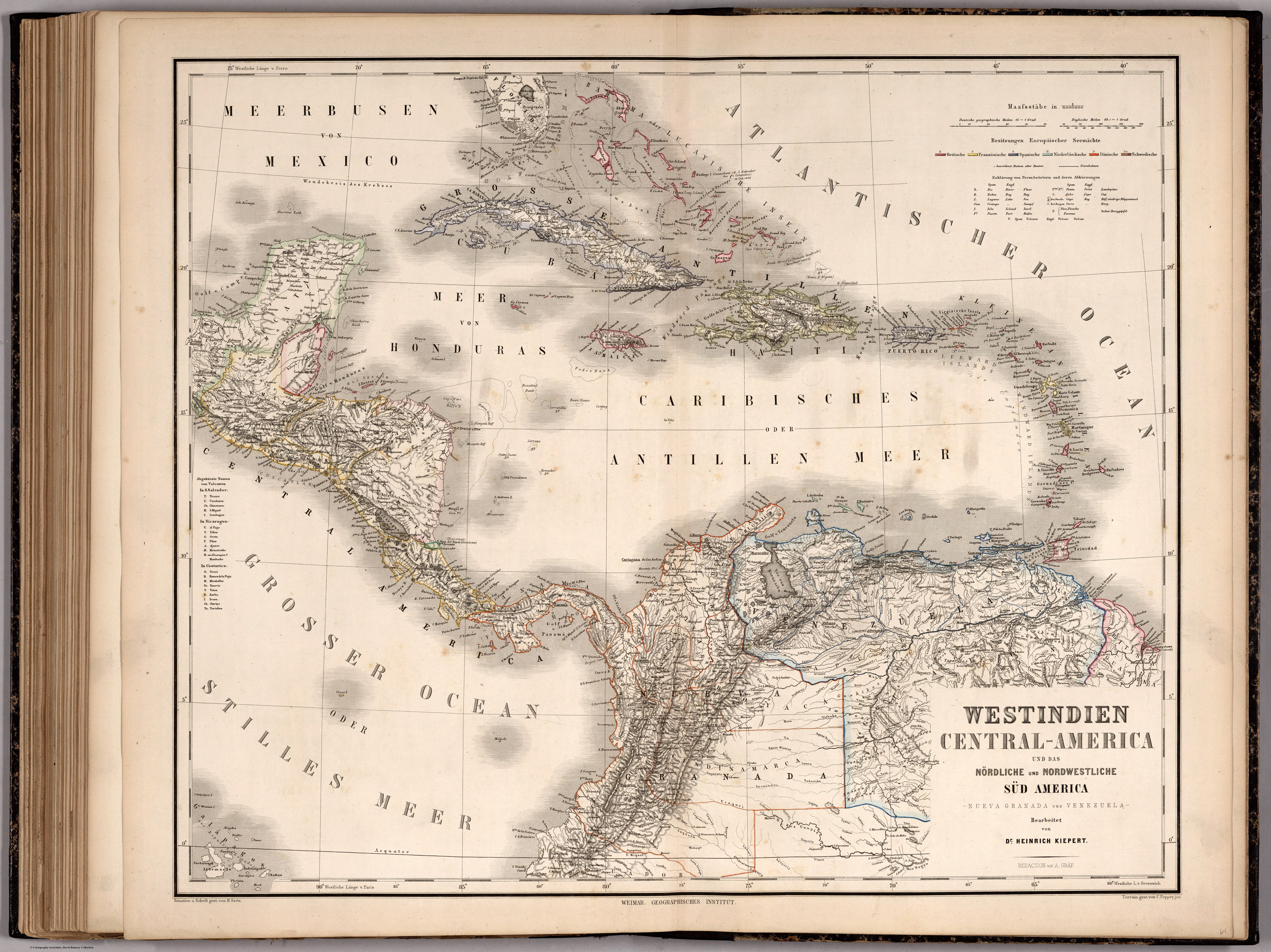
Dispossesions in the Americas

Dispossesions in the Americas

  • Home
  • Explore
  • About
  • Authors
  • Art
  • Bodies
  • Curricula
  • Cultural Heritage
  • Maps
  • Territories
Back to Explore
Map 1866

WESTINDIEN CENTRAL-AMERICA UND DAS NOERDLICHE UND NOERDWESTLICHE SUED AMERICA;NUEVA GRANADA UND VENEZUELA

  • KIEPERT;HEINRICH;ET AL.

Published: 1867

  • Download Image

Peoples

  • MAYAS
  • LACANDONES
  • OLANCHO
  • TOACAS
  • POYAS
  • MOSQUITO
  • KUSTE
  • GUAHIBOS
  • AMORUAS
  • PANARES
  • TAPARITOS
  • MACOS
  • PIAROAS
  • MAPOYES
  • MARIUSAS
  • CARIBEN
  • GUAYANOS
  • CAMARACOTO
  • ARINAGOTO
  • GUARAUNO
  • MARIQUITARES
  • MAYONGKONG
  • GUAIPUNAYOS
  • AZANENI
  • MACUENI

Citation

Kiepert, Heinrich, and Geographisches Institut. Westindien Central-America und das Noerdliche und Noerdwestliche Sued America, Nueva Granada und Venezuela. Map. Weimar: Weimar Geographisches Institut, 1866. Accessed December 24, 2022. https://www.davidrumsey.com/luna/servlet/detail/RUMSEY~8~1~265903~90040323:West-Indien,-Central-America-und-da?sort=pub_list_no_initialsort%2Cpub_date%2Cpub_list_no%2Cseries_no#.

  • Download Image

Reading in Spanish

Map 1866

WESTINDIEN CENTRAL-AMERICA UND DAS NOERDLICHE UND NOERDWESTLICHE SUED AMERICA;NUEVA GRANADA UND VENEZUELA

  • KIEPERT;HEINRICH;ET AL.

Published: 1867

  • Download Image
  • Download Image

Related Content

PUEBLO TLAHUICA

PUEBLO TLAHUICA

Map 2020
La Intendencia del Cuzco : Diuidida en todos los partidos o departamentos según las más individuales y exactas noticias de su capital, añadida y corregida por Pablo José Oricayn, año de 1786.

La Intendencia del Cuzco : Diuidida en todos los partidos o departamentos según las más individuales y exactas noticias de su capital, añadida y corregida por Pablo José Oricayn, año de 1786.

Map 1786
Southern Tepehuan and Tepecano

Southern Tepehuan and Tepecano

Map 1969
Haush Indians of Tierra del Fuego

Haush Indians of Tierra del Fuego

Map 1800
Chinantec Municipios, 1950

Chinantec Municipios, 1950

Map 1950
AMERIQUE MERIDIONALE: BRESIL AUX PORTUGAIS: CAPITAINERIE DE RIO-IANEIRO

AMERIQUE MERIDIONALE: BRESIL AUX PORTUGAIS: CAPITAINERIE DE RIO-IANEIRO

Map 1757
PUEBLOS QUECHUAS

PUEBLOS QUECHUAS

Map 2021
Mapa con migraciones
de indígenas misioneros y fundación de pueblos en Uruguay

Mapa con migraciones de indígenas misioneros y fundación de pueblos en Uruguay

Map 1828 - 1832

Dispossessions in the Americas

A project by

University of Pennsylvania

Copyright 2024

With support from

Mellon Foundation

Site design & development

Element 84

Art Credits

Kiepert, Heinrich, and Geographisches Institut. Westindien Central-America und das Noerdliche und Noerdwestliche Sued America, Nueva Granada und Venezuela. Map. Weimar: Weimar Geographisches Institut, 1866. Accessed December 24, 2022. https://www.davidrumsey.com/luna/servlet/detail/RUMSEY~8~1~265903~90040323:West-Indien,-Central-America-und-da?sort=pub_list_no_initialsort%2Cpub_date%2Cpub_list_no%2Cseries_no#.

Site Pages

  • Home
  • Explore
  • About
  • Authors
  • Art
  • Bodies
  • Curricula
  • Cultural Heritage
  • Maps
  • Territories