Dispossesions in the Americas

Dispossesions in the Americas

  • Home
  • Explore
  • About
  • Authors
  • Art
  • Bodies
  • Curricula
  • Cultural Heritage
  • Maps
  • Territories
Back to Explore
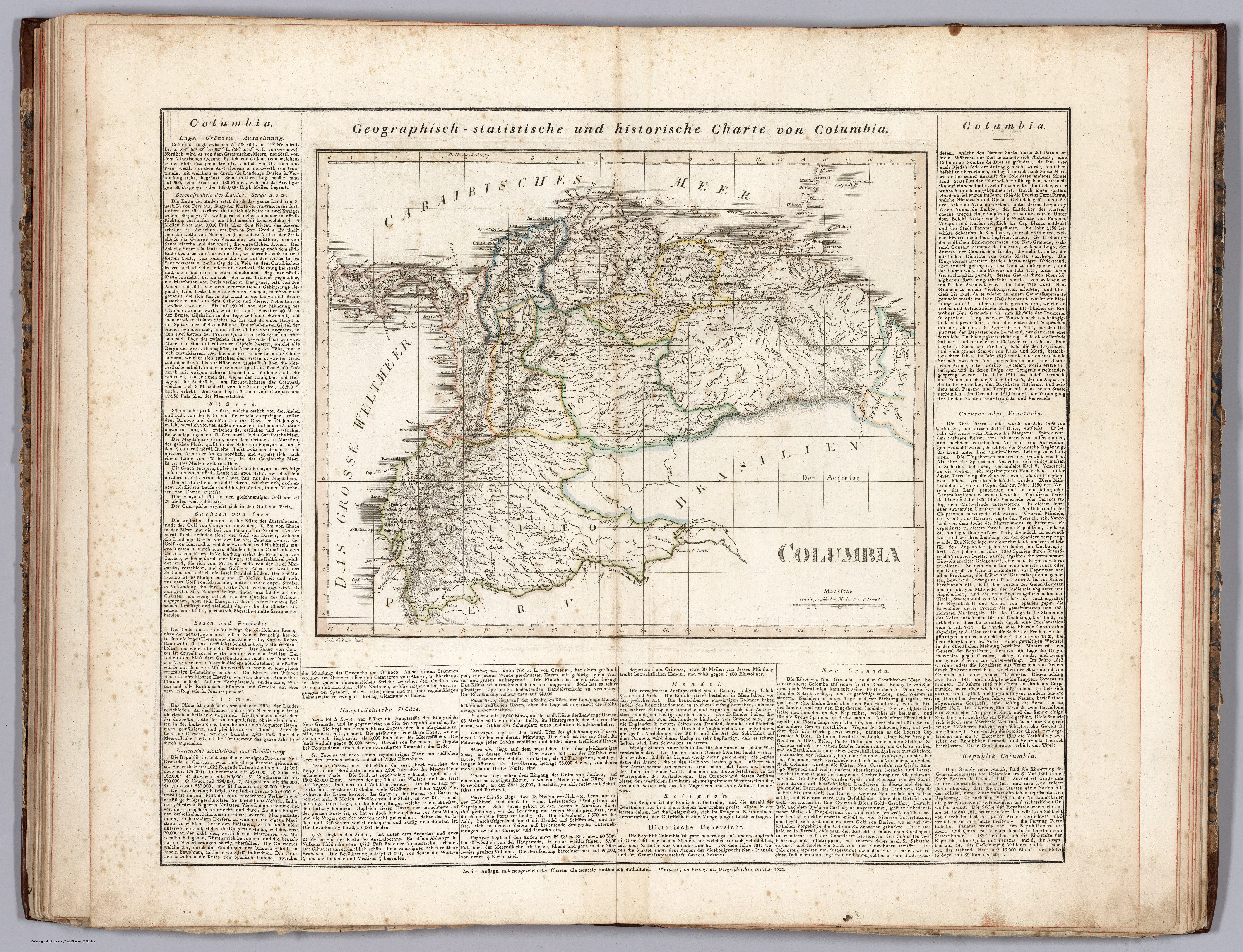
Map 1824

GEOGRAPHISCH-STATISTISCHE UND HISTORISCHE CHARTE VON COLUMBIA

  • WEILAND;CARL FERDINAND ET AL.

Published: 1829

  • Download Image

Peoples

  • MARIUSA

Citation

Weiland, Carl Ferdinand, and Georg Hassel. Columbia. Map. Weimar: Geographischen Instituts, 1824. Accessed November 20, 2022. https://www.davidrumsey.com/luna/servlet/detail/RUMSEY~8~1~297495~90069118:Columbia-?sort=pub_list_no_initialsort%2Cpub_date%2Cpub_list_no%2Cseries_no.
  • Download Image

Reading in Spanish

Map 1824

GEOGRAPHISCH-STATISTISCHE UND HISTORISCHE CHARTE VON COLUMBIA

  • WEILAND;CARL FERDINAND ET AL.

Published: 1829

  • Download Image
  • Download Image

Related Content

A Gente Rio /We River

A Gente Rio /We River

Artwork
d'Engelze Volkplanting in't Amerikaans gewest Gujana, en Rio de las Amazones

d'Engelze Volkplanting in't Amerikaans gewest Gujana, en Rio de las Amazones

Map 1700 - 1799
PROVINCIA DE MATTO GROSSO

PROVINCIA DE MATTO GROSSO

Map 1800 - 1850
Plano de la nueba Reducción de Yndios
     Mocobíes,titulada Nuestra Señora de los Dolores y Santiago de la
     Cangayeé erigida año 178

Plano de la nueba Reducción de Yndios Mocobíes,titulada Nuestra Señora de los Dolores y Santiago de la Cangayeé erigida año 178

Map 1780
Guatimala

Guatimala

Map 1680 - 1685
Cover-up of the Ponce de Leon statue at the Antorcha de la Amistad in Miami, Florida

Cover-up of the Ponce de Leon statue at the Antorcha de la Amistad in Miami, Florida

Artwork
Boom Creek Village

Boom Creek Village

Map 1997
REPRESENTACIÓN EN FORMA DE TRÍPTICO DE LAS TIERRAS DE TEPAL;CUENCA;CORRESPONDE AL EXPEDIENTE PROMOVIDO POR POSESIÓN DE TIERRAS ENTRE LOS INDÍGENAS DE SANTA ANA DE PICHACAY CONTRA MARÍA Y FRANCISCA CAZAR

REPRESENTACIÓN EN FORMA DE TRÍPTICO DE LAS TIERRAS DE TEPAL;CUENCA;CORRESPONDE AL EXPEDIENTE PROMOVIDO POR POSESIÓN DE TIERRAS ENTRE LOS INDÍGENAS DE SANTA ANA DE PICHACAY CONTRA MARÍA Y FRANCISCA CAZAR

Map 1828

Dispossessions in the Americas

A project by

University of Pennsylvania

Copyright 2024

With support from

Mellon Foundation

Site design & development

Element 84

Art Credits

Weiland, Carl Ferdinand, and Georg Hassel. Columbia. Map. Weimar: Geographischen Instituts, 1824. Accessed November 20, 2022. https://www.davidrumsey.com/luna/servlet/detail/RUMSEY~8~1~297495~90069118:Columbia-?sort=pub_list_no_initialsort%2Cpub_date%2Cpub_list_no%2Cseries_no.
Site Pages

  • Home
  • Explore
  • About
  • Authors
  • Art
  • Bodies
  • Curricula
  • Cultural Heritage
  • Maps
  • Territories