Dispossesions in the Americas

Dispossesions in the Americas

  • Home
  • Explore
  • About
  • Authors
  • Art
  • Bodies
  • Curricula
  • Cultural Heritage
  • Maps
  • Territories
Back to Explore
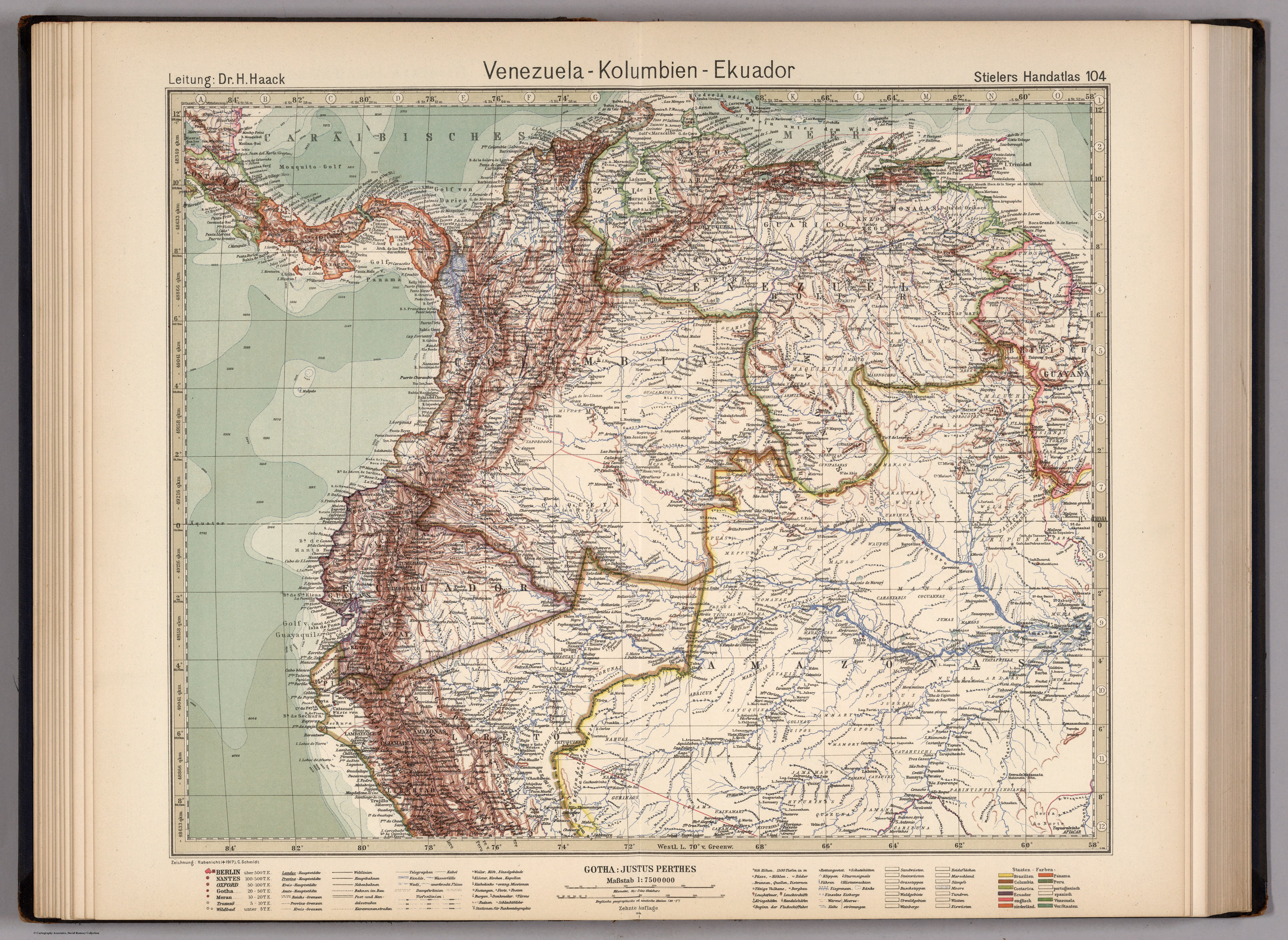
Map 1924

VENEZUELA - KOLUMBIEN – EKUADOR

  • HAACK;H. ET AL.

Published: 1925

  • Download Image

Peoples

  • TALAMANCA
  • GUARAUNOS
  • TAPARITO
  • GUAHIBOS
  • PIAROA
  • MAQUIRITARE
  • YOCURAS
  • MACOS
  • CADUPINAPOS
  • MAVITZI
  • MAIONGCONG
  • ARINAGOTOS
  • MAUCUS
  • WAICAS
  • AREK
  • WAPISIANAS
  • ATORAIS
  • TARUMAS
  • MACUCHIS
  • POROCOTOS
  • CURIARANAS
  • ABIRIANOS
  • PIAPOCOS
  • GUACAMAYOS
  • MITUAS
  • YAPOROGOS
  • YABANOS
  • CUNIPASANAS
  • OREMANAOS
  • BABAUANAS
  • CARAHYABY
  • UARIHUA
  • JAUAPERYS
  • CRICHANAS
  • SIRICUMES
  • CARIPUNAS
  • TARACUM
  • WAUPES
  • MANAO
  • MACU
  • MEPPURIS
  • JAPUAS
  • OMAGUAS
  • PASSES
  • TICUNAS
  • MIRANHA
  • XOMANAS
  • CAUIXANAS
  • MARAUAS
  • COCUANNAS
  • JUMAS
  • MURAS
  • ITATAPRIYAS
  • ARARAS
  • PURUS
  • JUBERIS
  • PAMMARY
  • GOLINAS
  • CATAUIX
  • MARAUNAS
  • CATUQUINA
  • ABAICUS
  • MAYORUNAS
  • COCAMAS
  • PIROS
  • AGUARUNAS
  • JIBAROS
  • SETEBOS
  • CONIBOS
  • PANOS
  • REMOS
  • CAPANAGUAS
  • NAHUAS
  • CIPOS
  • JAMAMADY
  • MAMORY
  • PAMANA
  • CATAUIXI
  • CATAHUICHI
  • PARINTINTIN-INDIANER
  • QUARUNA
  • HYPURINAS
  • CANAMARY
  • UAINAMARY
  • GURINAOS

Citation

Stieler, Adolf, and H. Haack. Venezuela - Kolumbien - Ekuador. Map. Gotha: Justus Perthes, 1925. Accessed December 23, 2022. https://www.davidrumsey.com/luna/servlet/detail/RUMSEY~8~1~265694~90040013:104--VEN---Kolumbien---Ekuado?sort=pub_list_no_initialsort%2Cpub_list_no_initialsort%2Cpub_date%2Cpub_date.
  • Download Image

Reading in Spanish

Map 1924

VENEZUELA - KOLUMBIEN – EKUADOR

  • HAACK;H. ET AL.

Published: 1925

  • Download Image
  • Download Image

Related Content

Carta étnica del Gran Chaco en el umbral del s. XX

Carta étnica del Gran Chaco en el umbral del s. XX

Map 1890 - 1935
Descripción geográfica de las conversiones de Nuestro Señor Padre San Francisco, pertenecientes al Colegio de Propaganda Fide de Santa Rosa de Ocopa y de los Ríos de Xauxa, Guanuco, Puzuzu y Ucayali, que tributan sus aguas al Marañón;corregida según las nuevas observaciones hechas por el P. Pr. Apostólico Fr. Joseph Amich, este año de 1767.

Descripción geográfica de las conversiones de Nuestro Señor Padre San Francisco, pertenecientes al Colegio de Propaganda Fide de Santa Rosa de Ocopa y de los Ríos de Xauxa, Guanuco, Puzuzu y Ucayali, que tributan sus aguas al Marañón;corregida según las nuevas observaciones hechas por el P. Pr. Apostólico Fr. Joseph Amich, este año de 1767.

Map 1767
Plano general de las montañas orientales del Reino del Peru

Plano general de las montañas orientales del Reino del Peru

Map 1795
Carte de la Republique du Paraguay : (Cours du Parana et du Paraguay) : (Amerique Méridionale)

Carte de la Republique du Paraguay : (Cours du Parana et du Paraguay) : (Amerique Méridionale)

Map 1857 - 1859
SOUTH AMERICA FROM THE BEST AUTHORITIES

SOUTH AMERICA FROM THE BEST AUTHORITIES

Map 1802
Otoxha

Otoxha

Map 1997
Espacio de los pueblos Yumbos (Referencia al recuadro de las pp. 73-74)

Espacio de los pueblos Yumbos (Referencia al recuadro de las pp. 73-74)

Map -500 - 1550
Geographic Distribution of the Mixtec

Geographic Distribution of the Mixtec

Map 1969

Dispossessions in the Americas

A project by

University of Pennsylvania

Copyright 2024

With support from

Mellon Foundation

Site design & development

Element 84

Art Credits

Stieler, Adolf, and H. Haack. Venezuela - Kolumbien - Ekuador. Map. Gotha: Justus Perthes, 1925. Accessed December 23, 2022. https://www.davidrumsey.com/luna/servlet/detail/RUMSEY~8~1~265694~90040013:104--VEN---Kolumbien---Ekuado?sort=pub_list_no_initialsort%2Cpub_list_no_initialsort%2Cpub_date%2Cpub_date.
Site Pages

  • Home
  • Explore
  • About
  • Authors
  • Art
  • Bodies
  • Curricula
  • Cultural Heritage
  • Maps
  • Territories