Dispossesions in the Americas

Dispossesions in the Americas

  • Home
  • Explore
  • About
  • Authors
  • Art
  • Bodies
  • Curricula
  • Cultural Heritage
  • Maps
  • Territories
Back to Explore
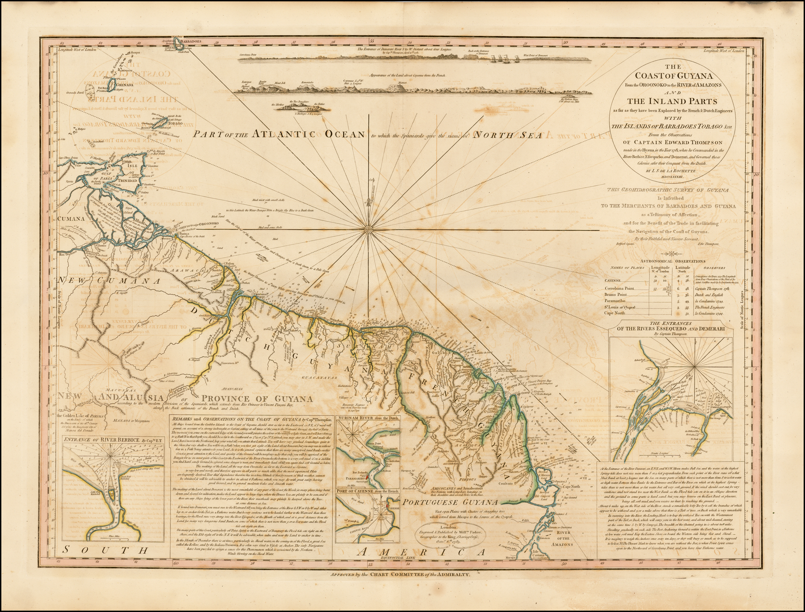
Map 1781

COAST OF GUYANA FROM THE OROONOKO TO THE RIVER OF AMAZONS AND THE INLAND PARTS AS FAR AS THEY HAVE BEEN EXPLORED BY THE FRENCH & DUTCH ENGINEERS WITH THE ISLANDS OF BARBADOS TOBAGO & CA.

  • L.;DELAROCHETTE

Published: 1783

  • Download Image

Peoples

  • GUARAUNAS
  • TIVITIVAS
  • ARAWACAS
  • GALIBIS
  • NORAGUES
  • GUACANAYAS
  • ATAYCAYAS
  • MACUSIAS
  • MANAOS
  • PALICOURS
  • ACOQUAS
  • MAYEZ
  • PIRIOUS
  • AMICOUANES
  • ARMABOUTOUS
  • COUSSARIS

Citation

Delarochette, L. Coast of Guyana From the Oroonoko to the River of Amazons and The Inland Parts as far as they have been Explored by the French & Dutch Engineers with the Islands of Barbados Tobago &ca. Map. London: William Faden, 1783. Accessed November 6, 2022. https://www.raremaps.com/gallery/detail/42155/the-coast-of-GUY-from-the-oroonoko-to-the-river-of-amazon-faden.
  • Download Image

Reading in Spanish

Map 1781

COAST OF GUYANA FROM THE OROONOKO TO THE RIVER OF AMAZONS AND THE INLAND PARTS AS FAR AS THEY HAVE BEEN EXPLORED BY THE FRENCH & DUTCH ENGINEERS WITH THE ISLANDS OF BARBADOS TOBAGO & CA.

  • L.;DELAROCHETTE

Published: 1783

  • Download Image
  • Download Image

Related Content

Las formas de propiedad y su registro: las tierras indígenas y recursos naturales

Las formas de propiedad y su registro: las tierras indígenas y recursos naturales

Map 2008
Map of the Inca Empire in western South America

Map of the Inca Empire in western South America

Map 1310 - 1525
Carte du Chili depuis le sud du Perou jusqu'au Cap Horn ...
     par Mr. Bonne, Ingr. Hydrographe de la Marine.

Carte du Chili depuis le sud du Perou jusqu'au Cap Horn ... par Mr. Bonne, Ingr. Hydrographe de la Marine.

Map 1780
El mapa de los pueblos indígenas de Bolivia

El mapa de los pueblos indígenas de Bolivia

Map 2007
Delimitación de la Gran Nación Wayuu

Delimitación de la Gran Nación Wayuu

Map 2015
MAPA DE OZTOTÍCPAC

MAPA DE OZTOTÍCPAC

Map 1500 - 1599
Ubicación histórica de los ópatas

Ubicación histórica de los ópatas

Map 1959
Mapa de la República de Guatemala

Mapa de la República de Guatemala

Map 1800 - 1900

Dispossessions in the Americas

A project by

University of Pennsylvania

Copyright 2024

With support from

Mellon Foundation

Site design & development

Element 84

Art Credits

Delarochette, L. Coast of Guyana From the Oroonoko to the River of Amazons and The Inland Parts as far as they have been Explored by the French & Dutch Engineers with the Islands of Barbados Tobago &ca. Map. London: William Faden, 1783. Accessed November 6, 2022. https://www.raremaps.com/gallery/detail/42155/the-coast-of-GUY-from-the-oroonoko-to-the-river-of-amazon-faden.
Site Pages

  • Home
  • Explore
  • About
  • Authors
  • Art
  • Bodies
  • Curricula
  • Cultural Heritage
  • Maps
  • Territories