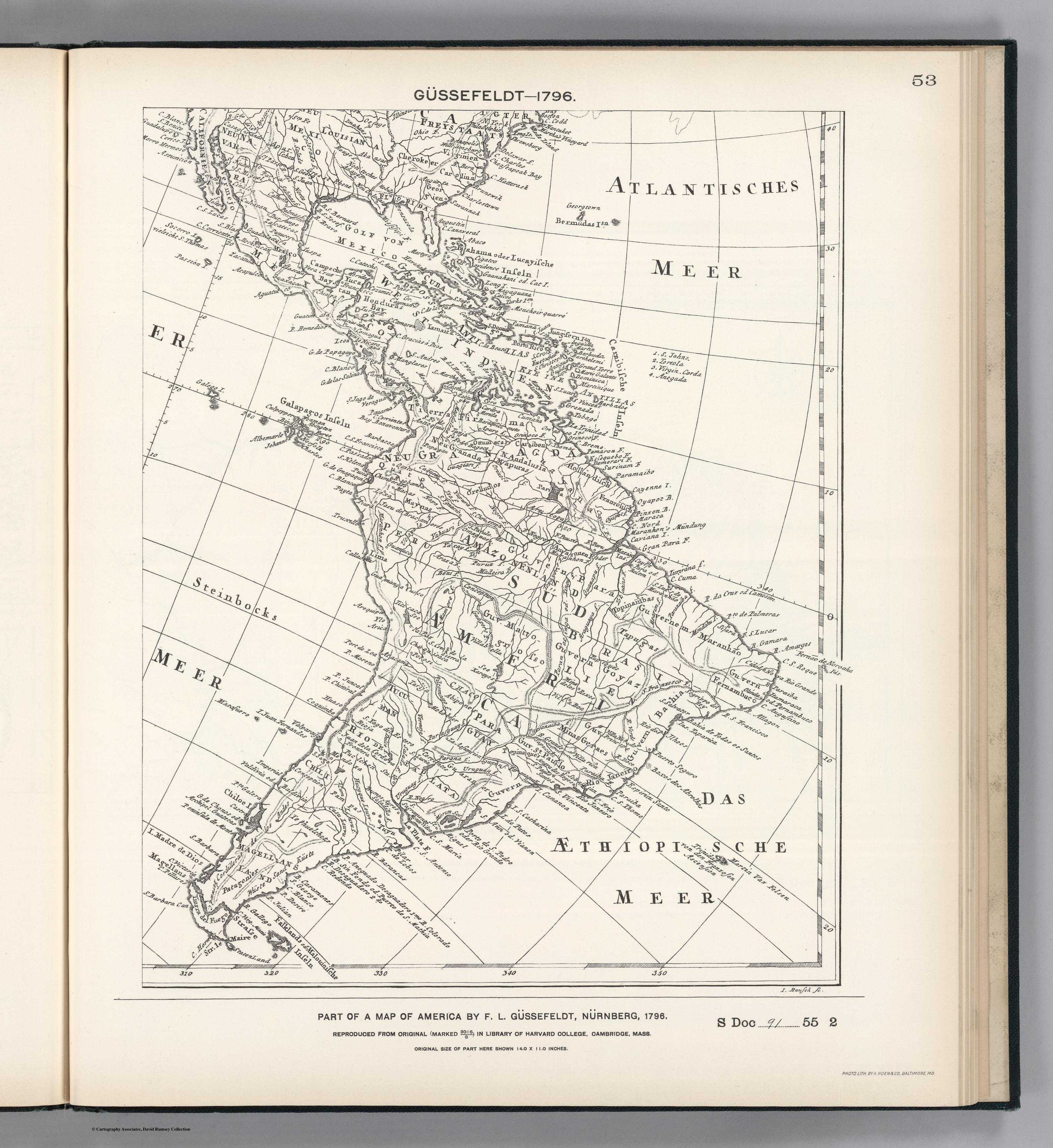
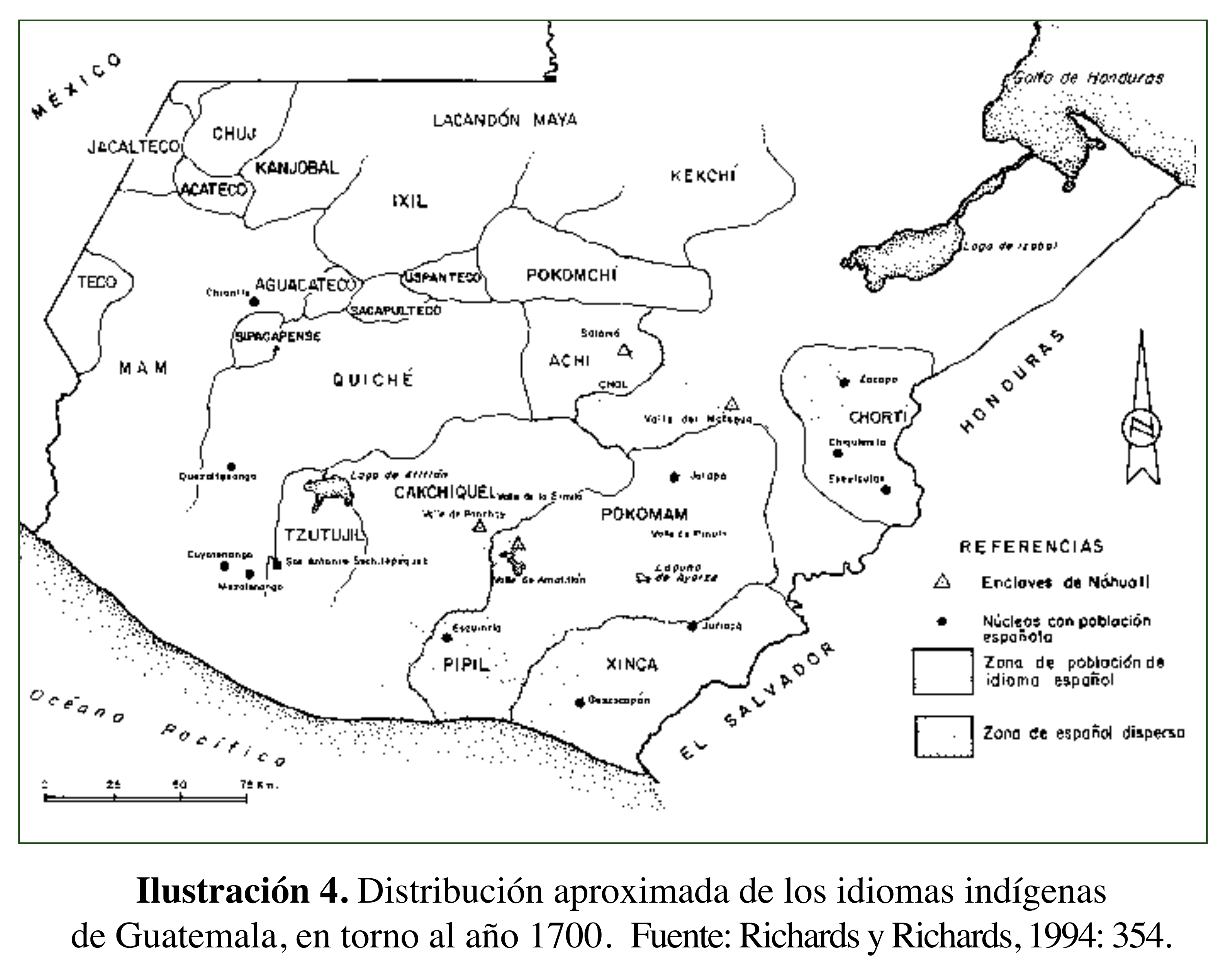
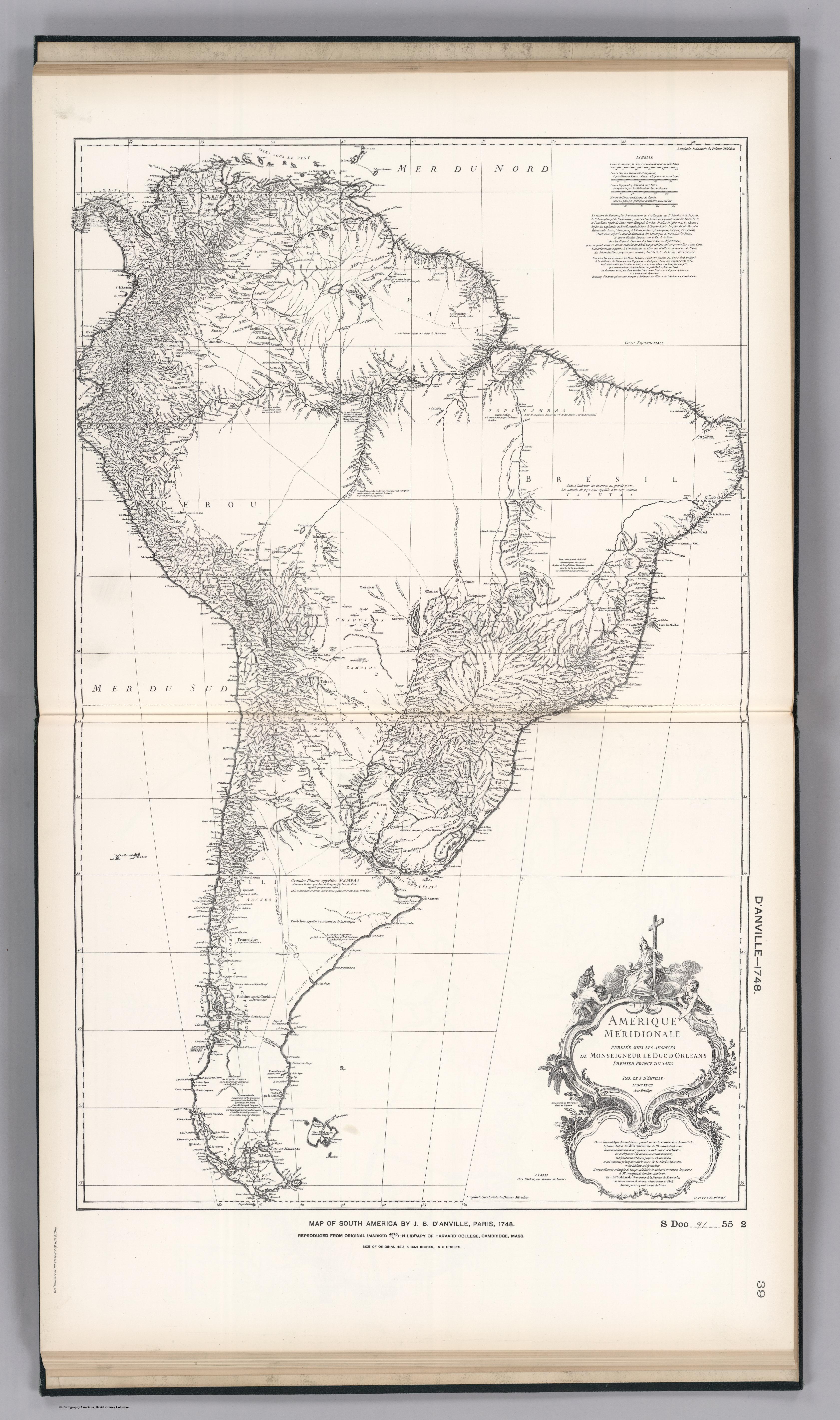
Dispossesions in the Americas

Dispossesions in the Americas

  • Home
  • Explore
  • About
  • Authors
  • Art
  • Bodies
  • Curricula
  • Cultural Heritage
  • Maps
  • Territories
Back to Explore
Map 1796

FACSIMILE: PART OF AMERICA BY GUSSEFELDT

  • GUSSEFELDT;F.L.

Published: 1897

  • Download Image

Peoples

  • CHEROKEER
  • CARIBEN
  • MAPURAS
  • ORELLUDOS
  • OTTUMACAS
  • MAYNAS
  • TOPINAMBAS
  • TAPUGAS
  • TUPIQUES
  • ABIPONER
  • MOKOBIER
  • TOPINAQUES
  • GUARANER
  • PAMPAS
  • PUCLCHEN
  • TEHUELCHETS
  • PATAGONIER

Citation

Gussefeldt, F. L. Facsimile: Part of America by Gussefeldt. Map. Washington, D.C.: United States of America, 1796. Accessed November 3, 2022. https://www.davidrumsey.com/luna/servlet/detail/RUMSEY~8~1~204036~3001772:Facsimile--Part-of-America-by-Gusse?sort=pub_list_no_initialsort%2Cpub_date%2Cpub_list_no%2Cseries_no.

  • Download Image

Reading in Spanish

Map 1796

FACSIMILE: PART OF AMERICA BY GUSSEFELDT

  • GUSSEFELDT;F.L.

Published: 1897

  • Download Image
  • Download Image

Reading in Portuguese

Map 1796

FACSIMILE: PART OF AMERICA BY GUSSEFELDT

  • GUSSEFELDT;F.L.

Published: 1897

  • Download Image

Peoples

  • CHEROKEER
  • CARIBEN
  • MAPURAS
  • ORELLUDOS
  • OTTUMACAS
  • MAYNAS
  • TOPINAMBAS
  • TAPUGAS
  • TUPIQUES
  • ABIPONER
  • MOKOBIER
  • TOPINAQUES
  • GUARANER
  • PAMPAS
  • PUCLCHEN
  • TEHUELCHETS
  • PATAGONIER

Citation

Gussefeldt, F. L. Facsimile: Part of America by Gussefeldt. Map. Washington, D.C.: United States of America, 1796. Accessed November 3, 2022. https://www.davidrumsey.com/luna/servlet/detail/RUMSEY~8~1~204036~3001772:Facsimile--Part-of-America-by-Gusse?sort=pub_list_no_initialsort%2Cpub_date%2Cpub_list_no%2Cseries_no.

  • Download Image

Related Content

Departamentos y municipios de mayor concentración del pueblo Cofán

Departamentos y municipios de mayor concentración del pueblo Cofán

Map 2005
Eastern Nicaragua

Eastern Nicaragua

Map 1928
Izquyluca; Tenayuca. Distrito Federal, 1594

Izquyluca; Tenayuca. Distrito Federal, 1594

Map 1594
GUIANA sive AMAZONUM REGIO

GUIANA sive AMAZONUM REGIO

Map 1600 - 1699
Terre de Sainte Croix, nommée apresent Bresil

Terre de Sainte Croix, nommée apresent Bresil

Map 1749
PROVINCIA DO ESPIRITO SANTO

PROVINCIA DO ESPIRITO SANTO

Map 1873
Zoque Towns

Zoque Towns

Map 1969
GOUVERNEMENT DU PARAGUAY ET PARTIE DU CHACO

GOUVERNEMENT DU PARAGUAY ET PARTIE DU CHACO

Map 1781

Dispossessions in the Americas

A project by

University of Pennsylvania

Copyright 2024

With support from

Mellon Foundation

Site design & development

Element 84

Art Credits

Gussefeldt, F. L. Facsimile: Part of America by Gussefeldt. Map. Washington, D.C.: United States of America, 1796. Accessed November 3, 2022. https://www.davidrumsey.com/luna/servlet/detail/RUMSEY~8~1~204036~3001772:Facsimile--Part-of-America-by-Gusse?sort=pub_list_no_initialsort%2Cpub_date%2Cpub_list_no%2Cseries_no.

Site Pages

  • Home
  • Explore
  • About
  • Authors
  • Art
  • Bodies
  • Curricula
  • Cultural Heritage
  • Maps
  • Territories