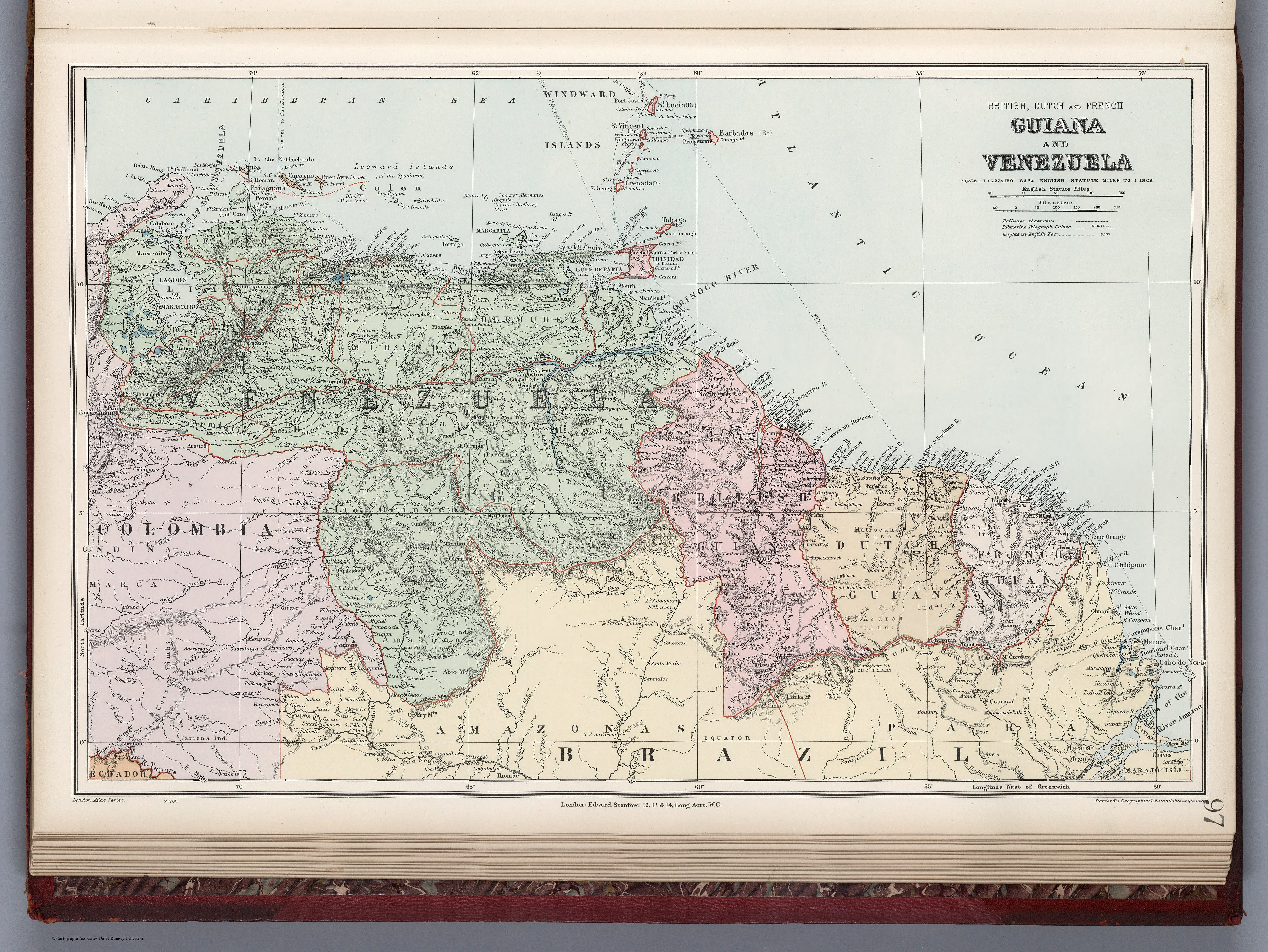
Dispossesions in the Americas

Dispossesions in the Americas

  • Home
  • Explore
  • About
  • Authors
  • Art
  • Bodies
  • Curricula
  • Cultural Heritage
  • Maps
  • Territories
Back to Explore
Map 1900 - 1999

GUIANA AND VENEZUELA

  • STANFORD;EDWARD

Published: 1904

  • Download Image

Peoples

  • GUAHIBO
  • MACO
  • PIAROA
  • TAPARITO
  • AGUARICOTO
  • AYANO
  • GUAIAUNO
  • PARABENA
  • ARINOGOTO
  • ARAWAK
  • GALIBIS
  • AUKAN
  • EMERILLON
  • KIRIKIRISCOTO
  • RUCUYENNE
  • ACURAI
  • MACUSI
  • WAPISIANA
  • ATORA
  • TARUMA
  • PIANOGHOTTO
  • GUINAU
  • PURIGOTO
  • PAUXIANA
  • MAQUIRITARE
  • AVERIANO
  • CURIARANA
  • GUAIPUNAYOS
  • AMORUA
  • MAYONGKONG
  • GUINARES
  • GUAHARIBO
  • TARIANA

Citation

Stanford, Edward. Guiana and Venezuela. Map. London: Edward Stanford, 1904. Accessed October 13, 2022. https://www.davidrumsey.com/luna/servlet/detail/RUMSEY~8~1~314744~90083536:Guiana-and-VEN-?sort=pub_list_no_initialsort%2Cpub_date%2Cpub_list_no%2Cseries_no.

  • Download Image

Reading in Spanish

Map 1900 - 1999

GUIANA AND VENEZUELA

  • STANFORD;EDWARD

Published: 1904

  • Download Image
  • Download Image

Related Content

Mosquitia or The Mosquito Shore with The Eastern Part of Yucatán as far as the 20th Degree of North Latitude

Mosquitia or The Mosquito Shore with The Eastern Part of Yucatán as far as the 20th Degree of North Latitude

Map 1787
Plan de l'isle de Pin

Plan de l'isle de Pin

Map 1692
Map of Chocho and Ichcatec Areas, Oaxaca0

Map of Chocho and Ichcatec Areas, Oaxaca0

Map 1969
Geographical Distribution of the Cuicatec

Geographical Distribution of the Cuicatec

Map 1969
LOS CACICAZGOS MUISCAS ALRDEDOR DE 1470

LOS CACICAZGOS MUISCAS ALRDEDOR DE 1470

Map 1470
Union des deux ocʹeans Atlantique et Pacifique;par le transit ouvert à travers la rʹepublique De Nicaragua : carte dʹetaillʹee des cinq dʹepartements avec indication des principaux tracʹes du Canal Interocʹeanique ...

Union des deux ocʹeans Atlantique et Pacifique;par le transit ouvert à travers la rʹepublique De Nicaragua : carte dʹetaillʹee des cinq dʹepartements avec indication des principaux tracʹes du Canal Interocʹeanique ...

Map 1855
Plan de la Rivière de Kourou et de la mission.

Plan de la Rivière de Kourou et de la mission.

Map 1700 - 1799
SONORA

SONORA

Map 2015

Dispossessions in the Americas

A project by

University of Pennsylvania

Copyright 2024

With support from

Mellon Foundation

Site design & development

Element 84

Art Credits

Stanford, Edward. Guiana and Venezuela. Map. London: Edward Stanford, 1904. Accessed October 13, 2022. https://www.davidrumsey.com/luna/servlet/detail/RUMSEY~8~1~314744~90083536:Guiana-and-VEN-?sort=pub_list_no_initialsort%2Cpub_date%2Cpub_list_no%2Cseries_no.

Site Pages

  • Home
  • Explore
  • About
  • Authors
  • Art
  • Bodies
  • Curricula
  • Cultural Heritage
  • Maps
  • Territories