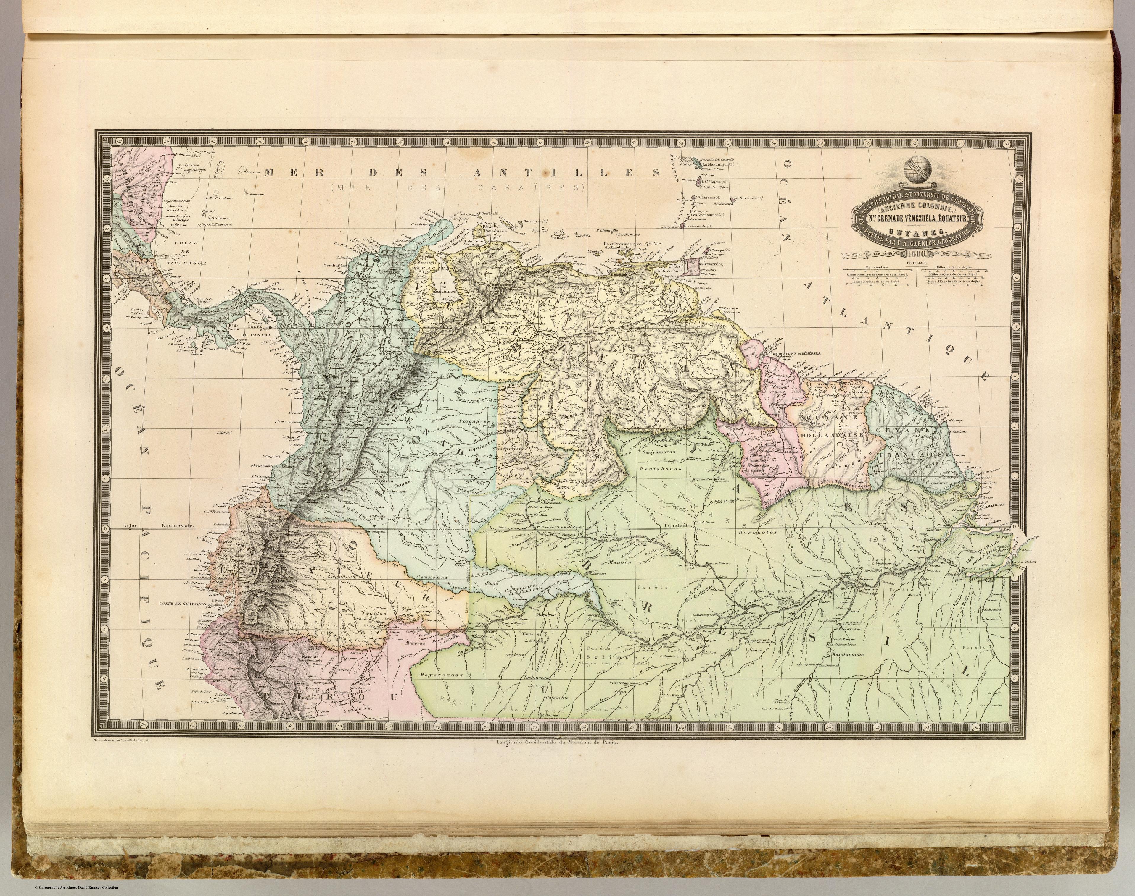
Dispossesions in the Americas

Dispossesions in the Americas

  • Home
  • Explore
  • About
  • Authors
  • Art
  • Bodies
  • Curricula
  • Cultural Heritage
  • Maps
  • Territories
Back to Explore
Map 1860

NLE. GRENADE;VENEZUELA;EQUATEUR;GUYANES.

  • GARNIER;F. A.

Published: 1862

  • Download Image

Peoples

  • MOTILONES
  • GUARAUNOS
  • GUAICAS
  • PANARES
  • AYANOS
  • MAPOYES
  • POIGNAVES
  • GUAHIBOS
  • MACOS
  • PIAROAS
  • MAQUIRITARES
  • GUINAUS
  • MAIONGEONG
  • PURIGOTOS
  • ARINAGOTOS
  • ARECUNAS
  • ARUACAS
  • ACAVAI
  • GALIBIS
  • OYAMPIS
  • CARUGUAN
  • TARYMAS
  • MACUSI
  • PAUISHANAS
  • OUAIYAMARAS
  • ZAPARAS
  • KIRISHANA
  • MACUENI
  • GUAIPUNAVOS
  • EQUINABIS
  • MANIVAS
  • ANDAQUIES
  • CAGUAN
  • TAMAS
  • COUSSARIS
  • BAROKOTOS
  • MANOAS
  • CAUXANAS
  • ZAPPAROS
  • IQUITOS
  • YAGUA
  • ICAAS
  • JURIS
  • CAYUCHARAS
  • CHUMANAS
  • MIRAGNOS
  • MARAOUAS
  • TUPINAMBARANAS
  • MUNDURUCUS
  • JUMAS
  • MUROS
  • YURIS
  • ARAICUS
  • TUCHINAOUAS
  • CATUQUIMAS
  • MAYAROUNAS
  • MAROVAS
  • MAYNAS
  • CONIBOS
  • SEPIBOS
  • CATAOCHIS
  • CIPO

Citation

Garnier, F. A. Nle. Grenade, Venezuela, Equateur, Guyanes. Map. Paris: Veuve Jules Renouard, Libraire, 1862. Accessed September 4, 2022. https://www.davidrumsey.com/luna/servlet/detail/RUMSEY~8~1~22054~710015:Ancienne-Colombie--Nle--Grenade,-Ve#.

  • Download Image

Reading in Spanish

Map 1860

NLE. GRENADE;VENEZUELA;EQUATEUR;GUYANES.

  • GARNIER;F. A.

Published: 1862

  • Download Image
  • Download Image

Related Content

Mapa del Corregimiento de Tecpanatitlan

Mapa del Corregimiento de Tecpanatitlan

Map 1690
THE ARGENTINE REPUBLIC;CHILE;PARAGUAY AND URUGUAY

THE ARGENTINE REPUBLIC;CHILE;PARAGUAY AND URUGUAY

Map 1887
Map of Nicaragua showing Ulwa settlements in Eastern Nicaragua and field study sites (in rectangle)

Map of Nicaragua showing Ulwa settlements in Eastern Nicaragua and field study sites (in rectangle)

Map 1990
Provincia de Zacatecas

Provincia de Zacatecas

Map 1600 - 1699
Geographisch-statistische und historische Charte von Guyana.

Geographisch-statistische und historische Charte von Guyana.

Map 1800 - 1899
Cited Toldería Locations, 1750-1806

Cited Toldería Locations, 1750-1806

Map 1750 - 1806
PUEBLO SHARANAHUA

PUEBLO SHARANAHUA

Map 2021
PUEBLO NAHUA DE SAN LUIS POTOSI

PUEBLO NAHUA DE SAN LUIS POTOSI

Map 2020

Dispossessions in the Americas

A project by

University of Pennsylvania

Copyright 2024

With support from

Mellon Foundation

Site design & development

Element 84

Art Credits

Garnier, F. A. Nle. Grenade, Venezuela, Equateur, Guyanes. Map. Paris: Veuve Jules Renouard, Libraire, 1862. Accessed September 4, 2022. https://www.davidrumsey.com/luna/servlet/detail/RUMSEY~8~1~22054~710015:Ancienne-Colombie--Nle--Grenade,-Ve#.

Site Pages

  • Home
  • Explore
  • About
  • Authors
  • Art
  • Bodies
  • Curricula
  • Cultural Heritage
  • Maps
  • Territories