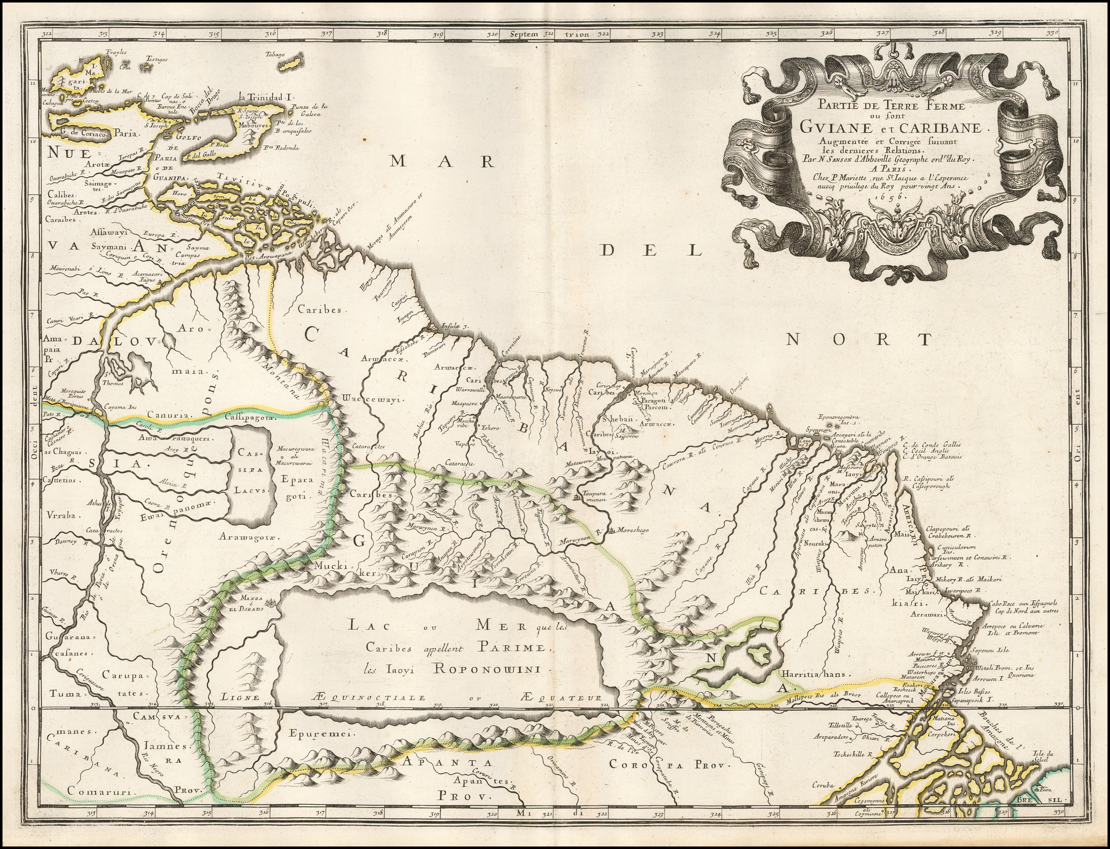
Dispossesions in the Americas

Dispossesions in the Americas

  • Home
  • Explore
  • About
  • Authors
  • Art
  • Bodies
  • Curricula
  • Cultural Heritage
  • Maps
  • Territories
Back to Explore
Map 1594 - 1596

Partie de Terre Ferme ou sont Guiane et Caribane. Augmentée et Corrigée suivant les dernières Relations

  • SANSON;MICOLAS

Published: 1656

  • Download Image

Peoples

  • CALIBES
  • SAIMAGOTES
  • AROTES
  • KALINAGO
  • SAYMANI
  • CHAGUAS
  • KAKETIO
  • VRRABA
  • GUARANACAFANES
  • TUMAMANES
  • CARAUPATATES
  • CARIBANA
  • COMARURI
  • IAMNES
  • APANTES
  • EPUREMEI
  • CARIBES
  • ARWACCAE
  • WACCEWAYI
  • CANURIA
  • AWARAWAQUERI
  • EWAIPANOMA
  • EPARAGOTOS
  • AROWAGOTOS
  • MUCHIKERI
  • SHEBAII
  • IAYOI
  • HARRITIAHANS
  • ANAKIARI
  • CARUPATES

Citation

Sanson, Nicolas. Partie de Terre Ferme ou sont Guiane et Caribane. Augmentée et Corrigée suivant les dernières Relations. Map. Paris, 1656. Accessed August 26, 2022. https://www.raremaps.com/gallery/detail/50489/partie-de-terre-ferme-ou-sont-guiane-et-caribane-augmentee-sanson.

  • Download Image

Reading in Spanish

Map 1594 - 1596

Partie de Terre Ferme ou sont Guiane et Caribane. Augmentée et Corrigée suivant les dernières Relations

  • SANSON;MICOLAS

Published: 1656

  • Download Image
  • Download Image

Related Content

Atacameños - Location

Atacameños - Location

Map 2012
AVA GUARANÍ

AVA GUARANÍ

Map 2015
Area de  las Poblaciones Lipez en Ollague antes de la Reduccion de 1602.

Area de las Poblaciones Lipez en Ollague antes de la Reduccion de 1602.

Map 1601
Mapa topográfico del Obispado de Truxillo del Perú. Construido por su actual Obispo en la visita general personal que acava de hacer en dicho obispado, quien lo dedica al Señor Dn. Carlos Tercero, Rey Católico de las Españas y Augusto emperador y verdadero padre de sus Américas ;y delineado por Dn. Josef Clemente de Castillo ;Baltasar Jaime, Obispo de Truxillo

Mapa topográfico del Obispado de Truxillo del Perú. Construido por su actual Obispo en la visita general personal que acava de hacer en dicho obispado, quien lo dedica al Señor Dn. Carlos Tercero, Rey Católico de las Españas y Augusto emperador y verdadero padre de sus Américas ;y delineado por Dn. Josef Clemente de Castillo ;Baltasar Jaime, Obispo de Truxillo

Map 1782 - 1785
Plano de Quetzaltenango, Guatemala.

Plano de Quetzaltenango, Guatemala.

Map 1800
[Partie de l'Oyapock]

[Partie de l'Oyapock]

Map 1700 - 1799
IDIOMAS DE GUATEMALA

IDIOMAS DE GUATEMALA

Map 1988
K. GUIANA. I. DAS BRITISCHE, II. [DAS] NIEDERLAENDISCHE, III. [DAS FRANZÖSISCHE.]

K. GUIANA. I. DAS BRITISCHE, II. [DAS] NIEDERLAENDISCHE, III. [DAS FRANZÖSISCHE.]

Map 1800 - 1899

Dispossessions in the Americas

A project by

University of Pennsylvania

Copyright 2024

With support from

Mellon Foundation

Site design & development

Element 84

Art Credits

Sanson, Nicolas. Partie de Terre Ferme ou sont Guiane et Caribane. Augmentée et Corrigée suivant les dernières Relations. Map. Paris, 1656. Accessed August 26, 2022. https://www.raremaps.com/gallery/detail/50489/partie-de-terre-ferme-ou-sont-guiane-et-caribane-augmentee-sanson.

Site Pages

  • Home
  • Explore
  • About
  • Authors
  • Art
  • Bodies
  • Curricula
  • Cultural Heritage
  • Maps
  • Territories