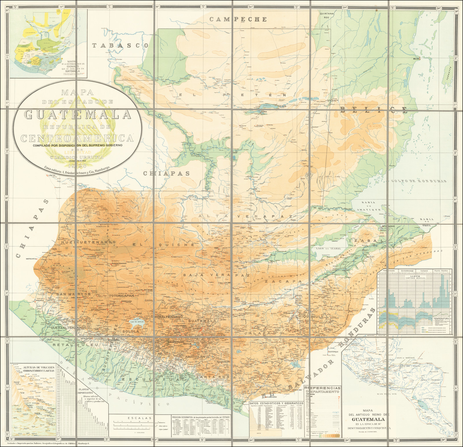
Dispossesions in the Americas

Dispossesions in the Americas

  • Home
  • Explore
  • About
  • Authors
  • Art
  • Bodies
  • Curricula
  • Cultural Heritage
  • Maps
  • Territories
Back to Explore
Map 1900 - 1999

MAPA DEL ANTIGUO REINO DE GUATEMALA EN LA EPOCA DE SU DESCUBRIMIENTO Y CONQUISTA

  • CLAUDIO URRUTIA

Published: 1923

  • Download Image

Peoples

  • ZOQUES
  • TABASCO
  • CHONTALACALAN
  • ZENDALES
  • CHIAPA
  • XOCONOXCO
  • ZOTZILES
  • MAMES
  • MAZATLAN
  • MAYAPAN
  • TIPU
  • PETEN
  • XUCHITEPEC
  • PIPILES
  • NAHUATLES
  • TZUTOHILES
  • KAQCHIKEL
  • RABINALEB
  • KICHE
  • CANIL
  • LACANDON
  • QEQCHI
  • POCHUTLA
  • MOPAN
  • TANIHA
  • CHOL
  • CHORTI
  • POQOMAM
  • XINCAS
  • NEQUEPIO
  • CHAPARRASTIC
  • HIBUERAS
  • LEAN
  • TOLUPAN
  • CHOROTEGA
  • TAGUZGALPA
  • PECH
  • TOANCAS
  • TOLOGALPA
  • CHONTAL
  • TALAMANCA

Citation

Urrutia, Claudio. MAPA DEL ANTIGUO REINO DE GUATEMALA EN LA EPOCA DE SU DESCUBRIMIENTO Y CONQUISTA. Map. Hamburg, Germany, 1923. Accessed April 24, 2022. https://www.raremaps.com/gallery/detail/68519.

  • Download Image

Reading in Spanish

Map 1900 - 1999

MAPA DEL ANTIGUO REINO DE GUATEMALA EN LA EPOCA DE SU DESCUBRIMIENTO Y CONQUISTA

  • CLAUDIO URRUTIA

Published: 1923

  • Download Image
  • Download Image

Related Content

Carte particulière de la Coste de Cayenne depuis le Cap Nord jusques au Païs des Saimakotes

Carte particulière de la Coste de Cayenne depuis le Cap Nord jusques au Païs des Saimakotes

Map 1600 - 1699
Carte des provinces de Nicaragua et Costa Rica

Carte des provinces de Nicaragua et Costa Rica

Map 1764
La France Antarctique autrement le Rio de Janeiro

La France Antarctique autrement le Rio de Janeiro

Map 1557 - 1558
Provinces depéndant de la triple alliance

Provinces depéndant de la triple alliance

Map
Tequistlatec and Tlapanec Areas, Mexico

Tequistlatec and Tlapanec Areas, Mexico

Map 1915
La región andina central ecuatoriana

La región andina central ecuatoriana

Map -500 - 1550
CÓDICE FEJÉRVARY-MAYER, FOLIO 1

CÓDICE FEJÉRVARY-MAYER, FOLIO 1

Map 1400 - 1599
REPÚBLICA DEL PARAGUAY INSTITUTO PARAGUAYO DEL INDÍGENA (I.N.D.I.) PARCIALIDADES INDÍGENAS ACTUALES

REPÚBLICA DEL PARAGUAY INSTITUTO PARAGUAYO DEL INDÍGENA (I.N.D.I.) PARCIALIDADES INDÍGENAS ACTUALES

Map

Dispossessions in the Americas

A project by

University of Pennsylvania

Copyright 2024

With support from

Mellon Foundation

Site design & development

Element 84

Art Credits

Urrutia, Claudio. MAPA DEL ANTIGUO REINO DE GUATEMALA EN LA EPOCA DE SU DESCUBRIMIENTO Y CONQUISTA. Map. Hamburg, Germany, 1923. Accessed April 24, 2022. https://www.raremaps.com/gallery/detail/68519.

Site Pages

  • Home
  • Explore
  • About
  • Authors
  • Art
  • Bodies
  • Curricula
  • Cultural Heritage
  • Maps
  • Territories