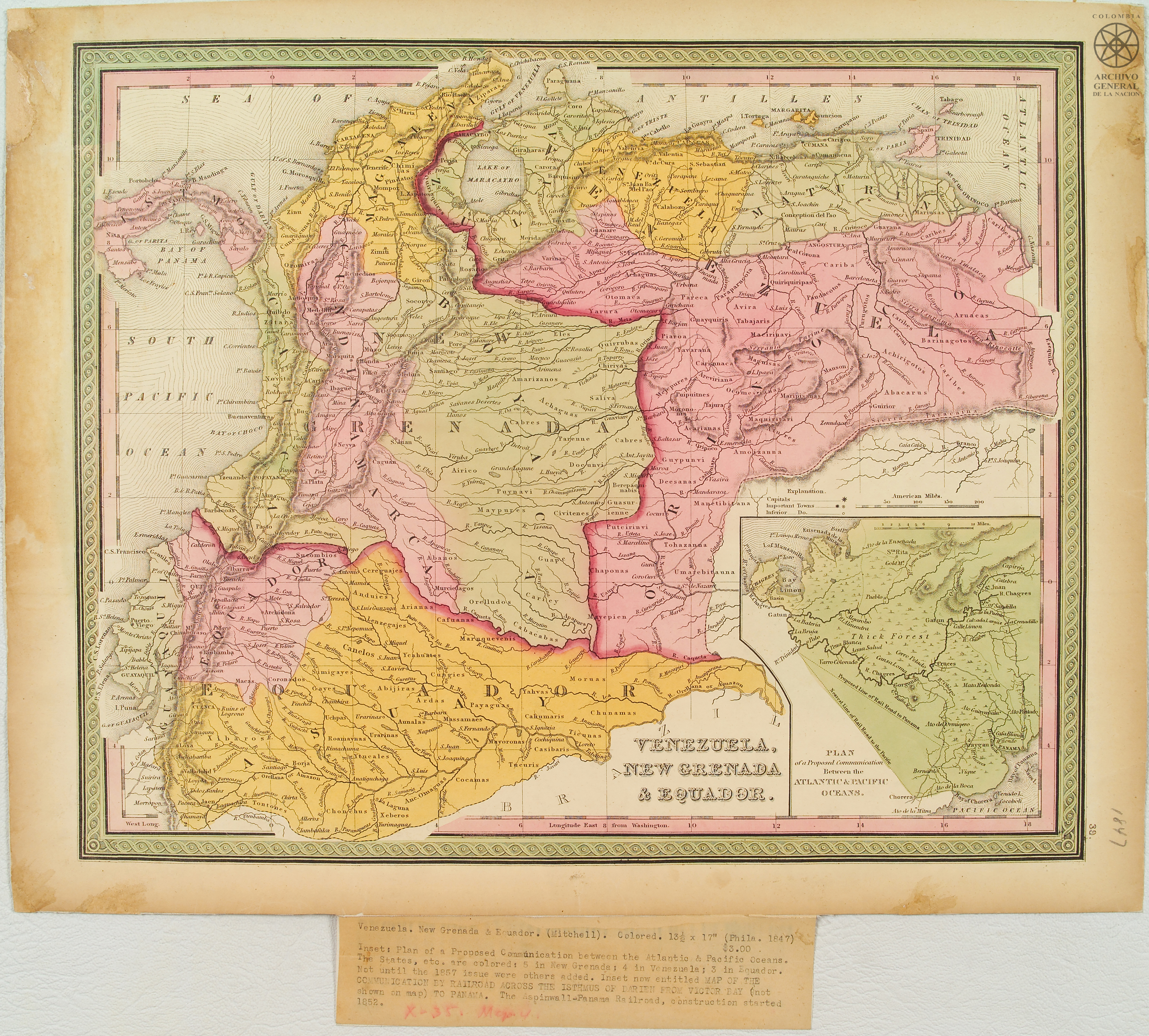
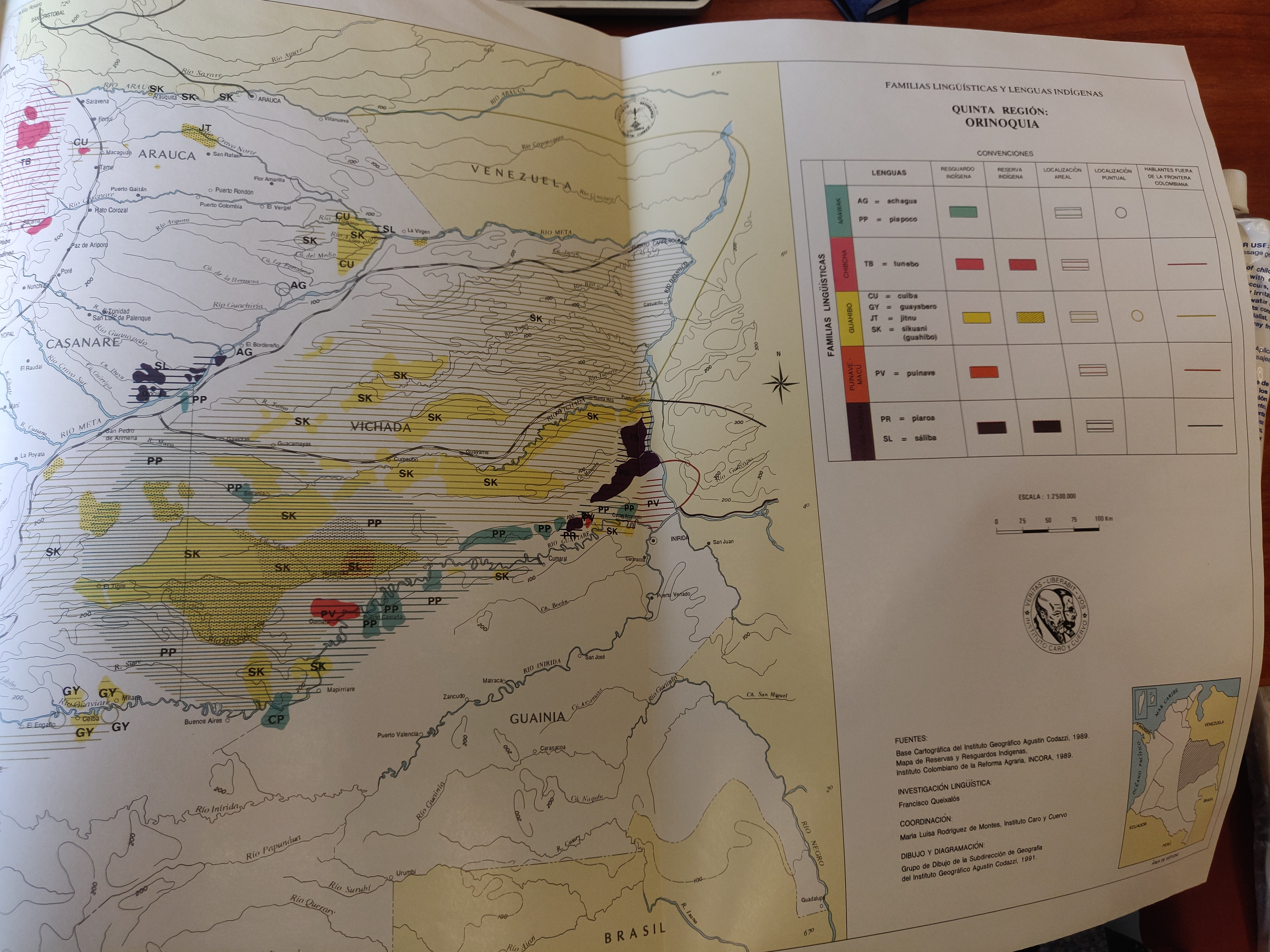
Dispossesions in the Americas

Dispossesions in the Americas

  • Home
  • Explore
  • About
  • Authors
  • Art
  • Bodies
  • Curricula
  • Cultural Heritage
  • Maps
  • Territories
Back to Explore
Map 1847

Venezuela;New Granada & Equador.

  • Mitchell;Samuel Augustus

Published: 1847

  • Download Image

Peoples

  • IPARAS
  • CHIMILAS
  • PINDATOS
  • QUIRIQUIRES
  • ZINU
  • CUNACUNAS
  • OROMIRAS
  • TONTONTES
  • CHONCHUS
  • XEBEROS
  • OMAGUAS
  • COCAMAS
  • TUCURIS
  • CASIBARIS
  • TICUNAS
  • CALUMARIS
  • MAYORONAS
  • YTUCALES
  • XIBAROS
  • CORONADOS
  • SIMIGAYES
  • ROAMAYNAS
  • URARINAS
  • AUNALAS
  • MASSAMAES
  • PAYAGUAS
  • MAYORONAS
  • ARDAS
  • ABIJIRAS
  • GAYES
  • SIMIGAYES
  • YAHVAS
  • MORUAS
  • CHUNAMAS
  • UMAREBITAUNA
  • TOAZANNA
  • MANETIBITANA
  • MAYEPIEN
  • CHAPONAS
  • PUTCIRINVI
  • GUASURIENNE
  • CIVITENES
  • GUAPE
  • CARIEY
  • CABACABAS
  • ORELLUDOS
  • ABANOS
  • MAYPURES
  • CAFUANAS
  • ARIANAS
  • CANELOS
  • YCAHUATES
  • ANDUIES
  • CEREGUAJES
  • LENZEGAJES
  • SIMIGAYES
  • SUCOMBIOS
  • GENTILES
  • AMARIZANO
  • ACHAGUA
  • SALIVA
  • AIRICO
  • PUYNAVI
  • PARENNE
  • CABRES
  • DOCUNVI
  • ELES
  • QUIRRUBAS
  • CHIRIVAS
  • SALIVA
  • DEESANA
  • GUAIPUNABE
  • MEJEPURE
  • PIAROA
  • YAVARANA
  • PUIPUITNE
  • YAYURA
  • MAIPURE
  • ACARIANA
  • AMOIZANA
  • ATURES
  • MAQUIRITARES
  • MARIPISANAS
  • CARINACO
  • YEKUANA
  • MAGUISAS
  • MANETIBITANA
  • ABACARA
  • ACHIRIGOTO
  • CARIBE
  • PEMON
  • ARAWAK
  • CARIBA
  • QUIRIQUIRIPAS
  • PAUDACOTOS
  • TABAJARI
  • AVIRA
  • WARIKERI
  • PAREKA
  • PARAPARUCOTA
  • YARURO
  • OTOMACO
  • JIRAJARA
  • PURUGOTO
  • AREVIRIANA
  • OCOMESIANA
  • MARIUSA
  • PUTCIRINVI

Citation

Mitchell, Samuel Augustus. "Venezuela, New Granada & Equador" (1847). Archivo General de la Nación. http://190.71.140.50/view/4571.AccessedApril29,2022.

  • Download Image

Reading in Spanish

Map 1847

Venezuela;New Granada & Equador.

  • Mitchell;Samuel Augustus

Published: 1847

  • Download Image
  • Download Image

Reading in Portuguese

Map 1847

Venezuela;New Granada & Equador.

  • Mitchell;Samuel Augustus

Published: 1847

  • Download Image

Peoples

  • IPARAS
  • CHIMILAS
  • PINDATOS
  • QUIRIQUIRES
  • ZINU
  • CUNACUNAS
  • OROMIRAS
  • TONTONTES
  • CHONCHUS
  • XEBEROS
  • OMAGUAS
  • COCAMAS
  • TUCURIS
  • CASIBARIS
  • TICUNAS
  • CALUMARIS
  • MAYORONAS
  • YTUCALES
  • XIBAROS
  • CORONADOS
  • SIMIGAYES
  • ROAMAYNAS
  • URARINAS
  • AUNALAS
  • MASSAMAES
  • PAYAGUAS
  • MAYORONAS
  • ARDAS
  • ABIJIRAS
  • GAYES
  • SIMIGAYES
  • YAHVAS
  • MORUAS
  • CHUNAMAS
  • UMAREBITAUNA
  • TOAZANNA
  • MANETIBITANA
  • MAYEPIEN
  • CHAPONAS
  • PUTCIRINVI
  • GUASURIENNE
  • CIVITENES
  • GUAPE
  • CARIEY
  • CABACABAS
  • ORELLUDOS
  • ABANOS
  • MAYPURES
  • CAFUANAS
  • ARIANAS
  • CANELOS
  • YCAHUATES
  • ANDUIES
  • CEREGUAJES
  • LENZEGAJES
  • SIMIGAYES
  • SUCOMBIOS
  • GENTILES
  • AMARIZANO
  • ACHAGUA
  • SALIVA
  • AIRICO
  • PUYNAVI
  • PARENNE
  • CABRES
  • DOCUNVI
  • ELES
  • QUIRRUBAS
  • CHIRIVAS
  • SALIVA
  • DEESANA
  • GUAIPUNABE
  • MEJEPURE
  • PIAROA
  • YAVARANA
  • PUIPUITNE
  • YAYURA
  • MAIPURE
  • ACARIANA
  • AMOIZANA
  • ATURES
  • MAQUIRITARES
  • MARIPISANAS
  • CARINACO
  • YEKUANA
  • MAGUISAS
  • MANETIBITANA
  • ABACARA
  • ACHIRIGOTO
  • CARIBE
  • PEMON
  • ARAWAK
  • CARIBA
  • QUIRIQUIRIPAS
  • PAUDACOTOS
  • TABAJARI
  • AVIRA
  • WARIKERI
  • PAREKA
  • PARAPARUCOTA
  • YARURO
  • OTOMACO
  • JIRAJARA
  • PURUGOTO
  • AREVIRIANA
  • OCOMESIANA
  • MARIUSA
  • PUTCIRINVI

Citation

Mitchell, Samuel Augustus. "Venezuela, New Granada & Equador" (1847). Archivo General de la Nación. http://190.71.140.50/view/4571.AccessedApril29,2022.

  • Download Image

Related Content

Pueblos y territorios indĆ­genas de Honduras (2000)

Pueblos y territorios indĆ­genas de Honduras (2000)

Map 2000
Mapa de la ubicación de Pueblo Ranquel

Mapa de la ubicación de Pueblo Ranquel

Map 2016
A Map of part of Yucatan or of that Part of the Eastern Shore Within the Bay of Honduras Alloted to Great Britain for the Cutting of Logwood, in consequence of the Convention Signed with Spain on the 14th July 1786.

A Map of part of Yucatan or of that Part of the Eastern Shore Within the Bay of Honduras Alloted to Great Britain for the Cutting of Logwood, in consequence of the Convention Signed with Spain on the 14th July 1786.

Map 1700
Mapa intelectual o idea formada de lo que es el Río del Darién o Atrato sacada por Relación de los nat[urales] de aquel Pais: Contiene las bocas principales de d[ic]hos Rios, sus cienegas, caños y riecitos que dan agua a d[ic]ho Pr[incip]al. Año de 1781. A.A.

Mapa intelectual o idea formada de lo que es el Río del Darién o Atrato sacada por Relación de los nat[urales] de aquel Pais: Contiene las bocas principales de d[ic]hos Rios, sus cienegas, caños y riecitos que dan agua a d[ic]ho Pr[incip]al. Año de 1781. A.A.

Map 1781
Mapa de la Governacion del Paraguay y de la de Buenos Ayres con la linea divisoria de las tierras de EspaƱa y Portugal ajustada entre las dos Coronas aƱo 1750 cuya posesion se pretende tomar este aƱo de 1752

Mapa de la Governacion del Paraguay y de la de Buenos Ayres con la linea divisoria de las tierras de EspaƱa y Portugal ajustada entre las dos Coronas aƱo 1750 cuya posesion se pretende tomar este aƱo de 1752

Map 1752
MAPA LINGƜƍSTICO DEL PAIS

MAPA LINGƜƍSTICO DEL PAIS

Map 2009 - 2010
FAMILIAS LINGUISTICAS Y LENGUAS INDƍGENAS. QUINTA REGION: ORINOQUIA.

FAMILIAS LINGUISTICAS Y LENGUAS INDƍGENAS. QUINTA REGION: ORINOQUIA.

Map 1989
Paisaje [Landscape]

Paisaje [Landscape]

Artwork

Dispossessions in the Americas

A project by

University of Pennsylvania

Copyright 2024

With support from

Mellon Foundation

Site design & development

Element 84

Art Credits

Mitchell, Samuel Augustus. “Venezuela, New Granada & Equador” (1847). Archivo General de la Nación. http://190.71.140.50/view/4571.AccessedApril29,2022.

Site Pages

  • Home
  • Explore
  • About
  • Authors
  • Art
  • Bodies
  • Curricula
  • Cultural Heritage
  • Maps
  • Territories