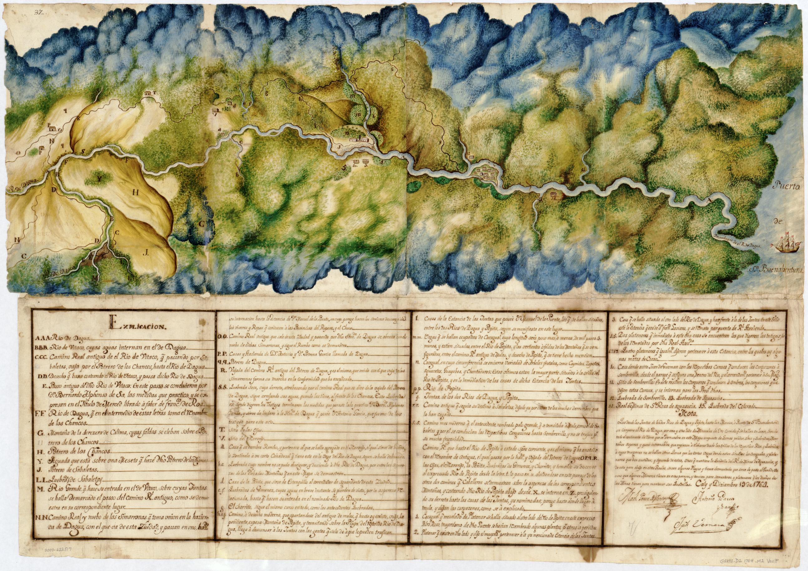
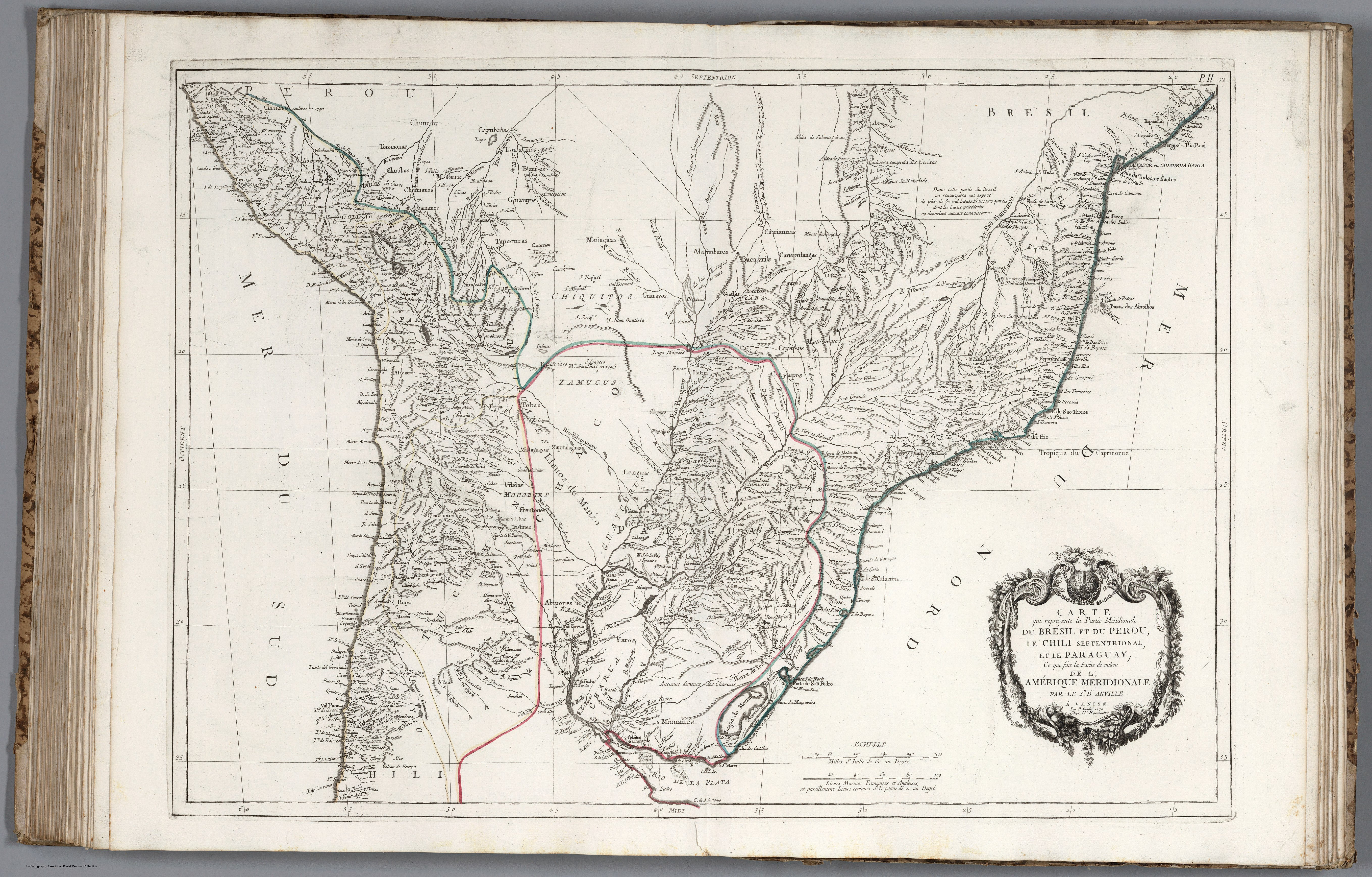
Dispossesions in the Americas

Dispossesions in the Americas

  • Home
  • Explore
  • About
  • Authors
  • Art
  • Bodies
  • Curricula
  • Cultural Heritage
  • Maps
  • Territories
Back to Explore
Map 1779

CARTE que représente la Partie Méridionale DU BRÉSIL ET DU PEROU;LE CHILI SEPTENTRIONAL;EL LE PARAGUAY;Ce qui fait la Pártie de milieu DE L’AMÉRIQUE MERIDIONALE PAR LE SR. D’ANVILLE À VENISE Par P. Santini 1779. Chez M’.Remondiri.

  • SANTINI;PAOLO;ET AL.

Published: 1784

  • Download Image

Peoples

  • CUNCHOS
  • CUNCHU
  • TOROMONAS
  • CHIRIBAS
  • CHUMANOS
  • RAMANOS
  • CAYUBABAS
  • ITONAMAS
  • BAURES
  • MOBIMAS
  • MOIOS
  • CAYAPOS
  • CARAYAS
  • CARIAPUTANGAS
  • CARIAUNAS
  • BACAYRIS
  • ALAIMBARES
  • GUALES
  • CUYABA
  • BOROROS
  • CHIQUITOS
  • GUARAYOS
  • MANACICAS
  • TAPACURAS
  • YURACARES
  • RACHES
  • CHIRIGUANES
  • VILELAS
  • MATAGUAYOS
  • ZAMUCOS
  • LENGUAS
  • ZAPITALAGUAS
  • TAYAS
  • PAYAGUAS
  • ITATIN
  • GUAYCURUS
  • ABIPONES
  • MOCOBIES
  • FRENTONES
  • ISISTINES
  • CHOROMOROS
  • CHARUA
  • YAROS
  • MINUANES
  • TAPPES

Citation

Santini, Paolo, and d'Anville. Carte qui Represente la Partie Meridionale du Bresil et du Perou, le Chili Septentrional, et le Paraguay ... de l'Amerique Meridionale. Map. Venice: Remondini, 1779. Accessed April 30, 2022. https://www.davidrumsey.com/luna/servlet/detail/RUMSEY~8~1~285877~90058393:52--Carte-qui-Represente-la-Partie-?sort=pub_list_no_initialsort%2Cpub_list_no_initialsort%2Cpub_date%2Cpub_date&qvq=w4s:/where%2FURU,sort:pub_list_no_initialsort%2Cpub_list_no_initialsort%2Cpub_date%2Cpub_date,lc:RUMSEY~8~1&mi=35&trs=95.

  • Download Image

Reading in Spanish

Map 1779

CARTE que représente la Partie Méridionale DU BRÉSIL ET DU PEROU;LE CHILI SEPTENTRIONAL;EL LE PARAGUAY;Ce qui fait la Pártie de milieu DE L’AMÉRIQUE MERIDIONALE PAR LE SR. D’ANVILLE À VENISE Par P. Santini 1779. Chez M’.Remondiri.

  • SANTINI;PAOLO;ET AL.

Published: 1784

  • Download Image
  • Download Image

Related Content

Mapa Mundi

Mapa Mundi

Map 1615
LINGUISTIC MAP OF MEXICO AND CENTRAL AMERICA

LINGUISTIC MAP OF MEXICO AND CENTRAL AMERICA

Map 1909
FAMILIAS LINGUÍSTICAS Y LENGUAS INDÍGENAS. CUARTA REGIÓN: AMAZONIA SEPTENTRIONAL

FAMILIAS LINGUÍSTICAS Y LENGUAS INDÍGENAS. CUARTA REGIÓN: AMAZONIA SEPTENTRIONAL

Map 1989
PROVINCIA DE MATTO GROSSO

PROVINCIA DE MATTO GROSSO

Map 1800 - 1850
Mapa de la Governacion del Paraguay y de la de Buenos Ayres con la linea divisoria de las tierras de España y Portugal ajustada entre las dos Coronas año 1750 cuya posesion se pretende tomar este año de 1752

Mapa de la Governacion del Paraguay y de la de Buenos Ayres con la linea divisoria de las tierras de España y Portugal ajustada entre las dos Coronas año 1750 cuya posesion se pretende tomar este año de 1752

Map 1752
MAPPA DO IMPERIO DO BRAZIL

MAPPA DO IMPERIO DO BRAZIL

Map 1878
Laguna

Laguna

Map 1997
Languages of Northwest Mexico

Languages of Northwest Mexico

Map 1700

Dispossessions in the Americas

A project by

University of Pennsylvania

Copyright 2024

With support from

Mellon Foundation

Site design & development

Element 84

Art Credits

Santini, Paolo, and d’Anville. Carte qui Represente la Partie Meridionale du Bresil et du Perou, le Chili Septentrional, et le Paraguay … de l’Amerique Meridionale. Map. Venice: Remondini, 1779. Accessed April 30, 2022. https://www.davidrumsey.com/luna/servlet/detail/RUMSEY~8~1~285877~90058393:52--Carte-qui-Represente-la-Partie-?sort=pub_list_no_initialsort%2Cpub_list_no_initialsort%2Cpub_date%2Cpub_date&qvq=w4s:/where%2FURU,sort:pub_list_no_initialsort%2Cpub_list_no_initialsort%2Cpub_date%2Cpub_date,lc:RUMSEY~8~1&mi=35&trs=95.

Site Pages

  • Home
  • Explore
  • About
  • Authors
  • Art
  • Bodies
  • Curricula
  • Cultural Heritage
  • Maps
  • Territories