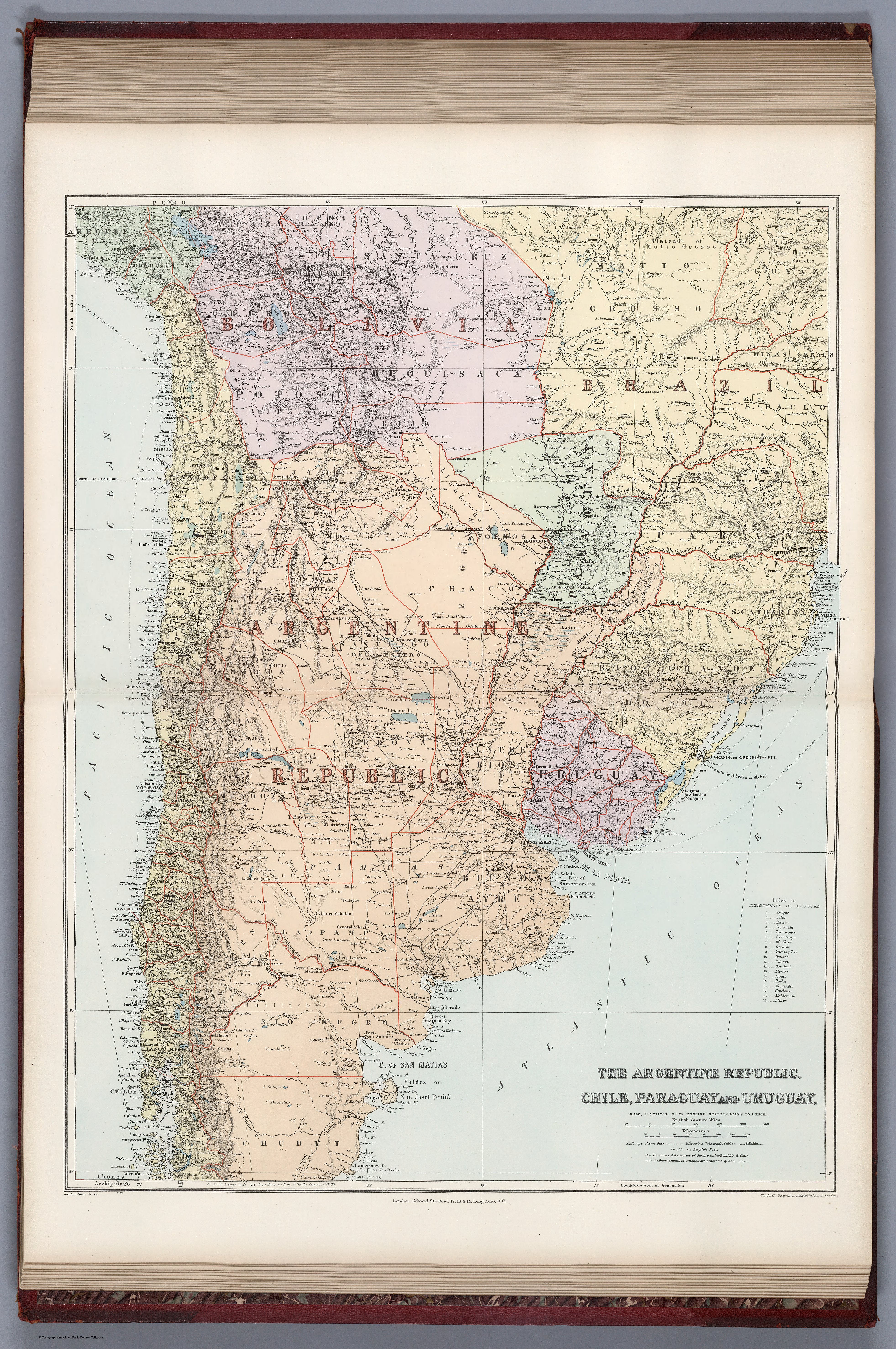
Dispossesions in the Americas

Dispossesions in the Americas

  • Home
  • Explore
  • About
  • Authors
  • Art
  • Bodies
  • Curricula
  • Cultural Heritage
  • Maps
  • Territories
Back to Explore
Map 1887

THE ARGENTINE REPUBLIC;CHILE;PARAGUAY AND URUGUAY

  • STANFORD;EDWARD

Published: 1904

  • Download Image

Peoples

  • YURACARAS
  • MOSETENE
  • CHIRIHUANO
  • CAYAPO
  • TEHUELCHES
  • HUILLICHES
  • RANQUELES

Citation

Stanford, Edward. Argentine Republic, Chile, Paraguay, Uruguay. Map. London: Edward Stanford, 1904. Accessed April 30, 2022. https://www.davidrumsey.com/luna/servlet/detail/RUMSEY~8~1~314746~90083534:Argentine-Republic,-CHI,-PAR?sort=pub_list_no_initialsort%2Cpub_list_no_initialsort%2Cpub_date%2Cpub_date&qvq=w4s:/where%2FURU,sort:pub_list_no_initialsort%2Cpub_list_no_initialsort%2Cpub_date%2Cpub_date,lc:RUMSEY~8~1&mi=24&trs=95.

  • Download Image

Reading in Spanish

Map 1887

THE ARGENTINE REPUBLIC;CHILE;PARAGUAY AND URUGUAY

  • STANFORD;EDWARD

Published: 1904

  • Download Image
  • Download Image

Related Content

Mapa del Gran Chaco y Provincias Adyacentes.

Mapa del Gran Chaco y Provincias Adyacentes.

Map 1885
Eclipse Solar [Solar Eclipse]

Eclipse Solar [Solar Eclipse]

Artwork
Cùst, van, Brasilia

Cùst, van, Brasilia

Map 1600 - 1699
RELACIÓN GEOGRÁFICA DEL PUEBLO Y MINAS DE ZIMAPÁN

RELACIÓN GEOGRÁFICA DEL PUEBLO Y MINAS DE ZIMAPÁN

Map 1500 - 1599
CÓDICE VINDOBONENSIS MEXICANUS 1, P.3

CÓDICE VINDOBONENSIS MEXICANUS 1, P.3

Map 1500 - 1599
Tequistlatec and Tlapanec Areas, Mexico

Tequistlatec and Tlapanec Areas, Mexico

Map 1915
PROVINCIA DO MARANHAO

PROVINCIA DO MARANHAO

Map 1800 - 1850
ALGUNOS ESTABLECIMIENTOS ESPANOLES Y PUELOS DE INDIOS "REBELDES" A FINALES DEL SIGLO XVII

ALGUNOS ESTABLECIMIENTOS ESPANOLES Y PUELOS DE INDIOS "REBELDES" A FINALES DEL SIGLO XVII

Map 1600 - 1699

Dispossessions in the Americas

A project by

University of Pennsylvania

Copyright 2024

With support from

Mellon Foundation

Site design & development

Element 84

Art Credits

Stanford, Edward. Argentine Republic, Chile, Paraguay, Uruguay. Map. London: Edward Stanford, 1904. Accessed April 30, 2022. https://www.davidrumsey.com/luna/servlet/detail/RUMSEY~8~1~314746~90083534:Argentine-Republic,-CHI,-PAR?sort=pub_list_no_initialsort%2Cpub_list_no_initialsort%2Cpub_date%2Cpub_date&qvq=w4s:/where%2FURU,sort:pub_list_no_initialsort%2Cpub_list_no_initialsort%2Cpub_date%2Cpub_date,lc:RUMSEY~8~1&mi=24&trs=95.

Site Pages

  • Home
  • Explore
  • About
  • Authors
  • Art
  • Bodies
  • Curricula
  • Cultural Heritage
  • Maps
  • Territories