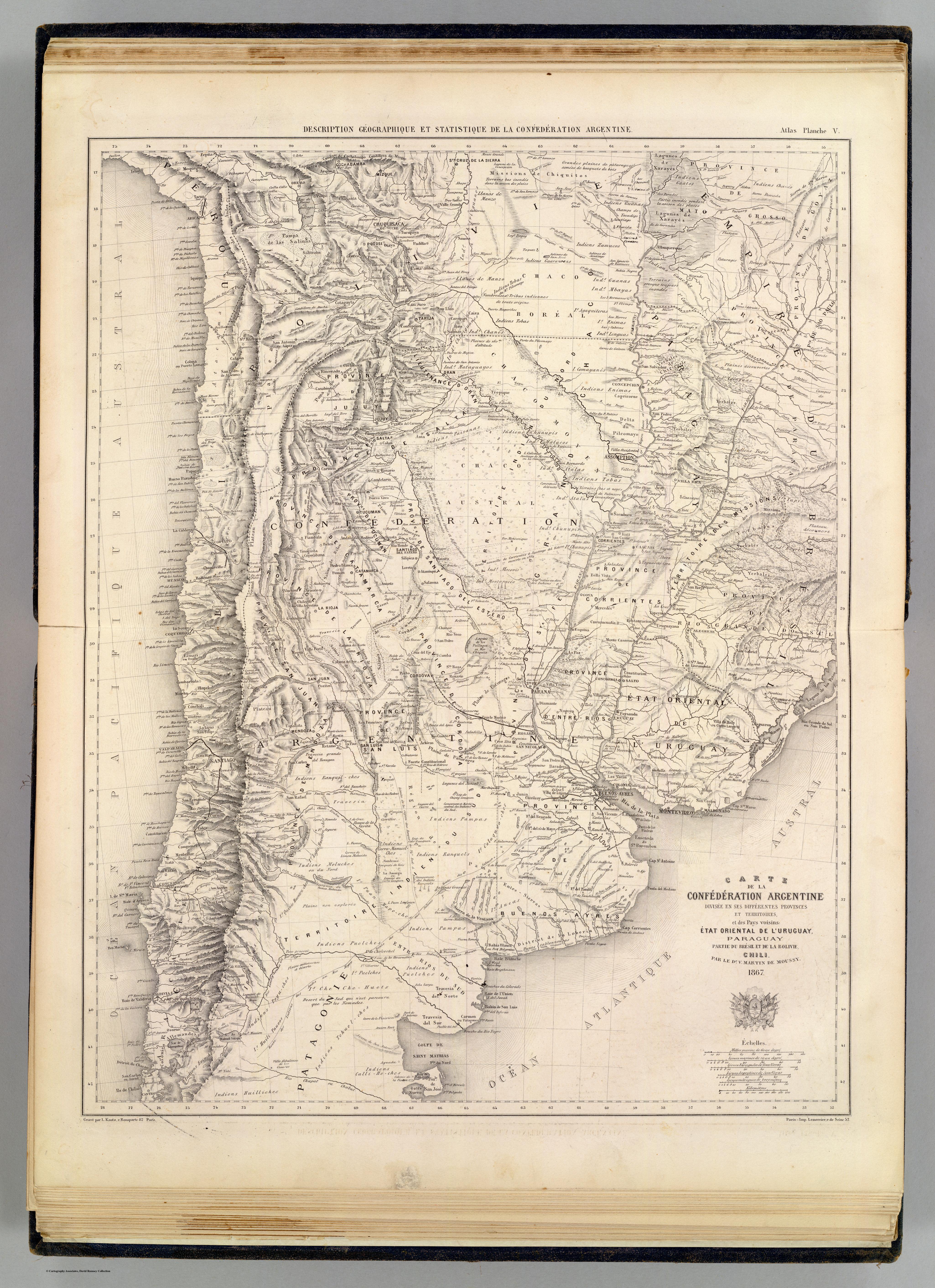
Dispossesions in the Americas

Dispossesions in the Americas

  • Home
  • Explore
  • About
  • Authors
  • Art
  • Bodies
  • Curricula
  • Cultural Heritage
  • Maps
  • Territories
Back to Explore
Map 1873

CARTE DE LA CONFÉDÉRATION ARGENTINE

  • MARTIN DE MOUSSY;V.

Published: 1873

  • Download Image

Peoples

  • CHIQUITOS
  • GUATOS
  • CHANES
  • GUANAS
  • ZAMUCOS
  • GUARANOCAS
  • CHIRIGUANOS
  • TOBAS
  • MBAYAS
  • LENGUAS
  • ENIMAS
  • AYAQUITERAS
  • GUACHIS
  • CAINGUAS
  • COMAYANES
  • MATAGUAYOS
  • OCOLES
  • PAISANAS
  • CHUNUPIS
  • MATACOS
  • ATALAS
  • TUPIS
  • BUGRES
  • MOCOVIS
  • MONTARACES
  • RANQUILCHES
  • MOLUCHES
  • LAFRA HUENTRUCHES
  • CURRA-MAMUELCHES
  • RANQUELS
  • PAMPAS
  • COLUQUEOCHES
  • AUCAS
  • PUAN MAPOCHES
  • PUELCHES
  • CHOLEECHEL
  • QUINIE HUENTRUCHES
  • POYUCHES
  • HUILI-PAUVOS
  • CHE CHE-HUETS
  • TEHUELCHES
  • CALLI-HECHES
  • HUILLICHES
  • EVINCHES

Citation

Martin de Moussy, V. Carte de la Confederation Argentine. Map. Paris: Firmin Didot Freres, 1873. Accessed April 29, 2022. https://www.davidrumsey.com/luna/servlet/detail/RUMSEY~8~1~20533~510059:Carte-de-la-Confederation-Argentine?sort=pub_list_no_initialsort%2Cpub_list_no_initialsort%2Cpub_date%2Cpub_date&qvq=w4s:/where%2FURU,sort:pub_list_no_initialsort%2Cpub_list_no_initialsort%2Cpub_date%2Cpub_date,lc:RUMSEY~8~1&mi=9&trs=88.

  • Download Image

Reading in Spanish

Map 1873

CARTE DE LA CONFÉDÉRATION ARGENTINE

  • MARTIN DE MOUSSY;V.

Published: 1873

  • Download Image
  • Download Image

Reading in Portuguese

Map 1873

CARTE DE LA CONFÉDÉRATION ARGENTINE

  • MARTIN DE MOUSSY;V.

Published: 1873

  • Download Image

Peoples

  • CHIQUITOS
  • GUATOS
  • CHANES
  • GUANAS
  • ZAMUCOS
  • GUARANOCAS
  • CHIRIGUANOS
  • TOBAS
  • MBAYAS
  • LENGUAS
  • ENIMAS
  • AYAQUITERAS
  • GUACHIS
  • CAINGUAS
  • COMAYANES
  • MATAGUAYOS
  • OCOLES
  • PAISANAS
  • CHUNUPIS
  • MATACOS
  • ATALAS
  • TUPIS
  • BUGRES
  • MOCOVIS
  • MONTARACES
  • RANQUILCHES
  • MOLUCHES
  • LAFRA HUENTRUCHES
  • CURRA-MAMUELCHES
  • RANQUELS
  • PAMPAS
  • COLUQUEOCHES
  • AUCAS
  • PUAN MAPOCHES
  • PUELCHES
  • CHOLEECHEL
  • QUINIE HUENTRUCHES
  • POYUCHES
  • HUILI-PAUVOS
  • CHE CHE-HUETS
  • TEHUELCHES
  • CALLI-HECHES
  • HUILLICHES
  • EVINCHES

Citation

Martin de Moussy, V. Carte de la Confederation Argentine. Map. Paris: Firmin Didot Freres, 1873. Accessed April 29, 2022. https://www.davidrumsey.com/luna/servlet/detail/RUMSEY~8~1~20533~510059:Carte-de-la-Confederation-Argentine?sort=pub_list_no_initialsort%2Cpub_list_no_initialsort%2Cpub_date%2Cpub_date&qvq=w4s:/where%2FURU,sort:pub_list_no_initialsort%2Cpub_list_no_initialsort%2Cpub_date%2Cpub_date,lc:RUMSEY~8~1&mi=9&trs=88.

  • Download Image

Related Content

La Intendencia del Cuzco : Diuidida en todos los partidos o departamentos según las más individuales y exactas noticias de su capital, añadida y corregida por Pablo José Oricayn, año de 1786.

La Intendencia del Cuzco : Diuidida en todos los partidos o departamentos según las más individuales y exactas noticias de su capital, añadida y corregida por Pablo José Oricayn, año de 1786.

Map 1786
CARTE DU COURS DE L'AMAZONE DEPUIS L'OCÉAN JUSQU'À MANAOS ET DE LA GUYANE BRÉSILIENNE

CARTE DU COURS DE L'AMAZONE DEPUIS L'OCÉAN JUSQU'À MANAOS ET DE LA GUYANE BRÉSILIENNE

Map 1892 - 1906
Mapa particular del Golfo e Ystmo del Darien ocupados por la mayor parte de los indios gentiles enemigos crueles y alevosos de la Nacion española quanto amigos dela inglesa : para la inteligencia de los ataques que conviene hacerlos para su reducion o aniquilacion

Mapa particular del Golfo e Ystmo del Darien ocupados por la mayor parte de los indios gentiles enemigos crueles y alevosos de la Nacion española quanto amigos dela inglesa : para la inteligencia de los ataques que conviene hacerlos para su reducion o aniquilacion

Map 1700 - 1799
PUEBLO POPOLUCA DE LA SIERRA

PUEBLO POPOLUCA DE LA SIERRA

Map 2020
XI RONDA PETROLERA Y TERRITORIOS INDIGENAS

XI RONDA PETROLERA Y TERRITORIOS INDIGENAS

Map 2011
Ombre des Amazonies [Shadows of the Amazon]

Ombre des Amazonies [Shadows of the Amazon]

Artwork
Theories of Migration (Charrúas).

Theories of Migration (Charrúas).

Map 1680 - 1805
Area of Tarascan Speech about 1850

Area of Tarascan Speech about 1850

Map 1850

Dispossessions in the Americas

A project by

University of Pennsylvania

Copyright 2024

With support from

Mellon Foundation

Site design & development

Element 84

Art Credits

Martin de Moussy, V. Carte de la Confederation Argentine. Map. Paris: Firmin Didot Freres, 1873. Accessed April 29, 2022. https://www.davidrumsey.com/luna/servlet/detail/RUMSEY~8~1~20533~510059:Carte-de-la-Confederation-Argentine?sort=pub_list_no_initialsort%2Cpub_list_no_initialsort%2Cpub_date%2Cpub_date&qvq=w4s:/where%2FURU,sort:pub_list_no_initialsort%2Cpub_list_no_initialsort%2Cpub_date%2Cpub_date,lc:RUMSEY~8~1&mi=9&trs=88.

Site Pages

  • Home
  • Explore
  • About
  • Authors
  • Art
  • Bodies
  • Curricula
  • Cultural Heritage
  • Maps
  • Territories