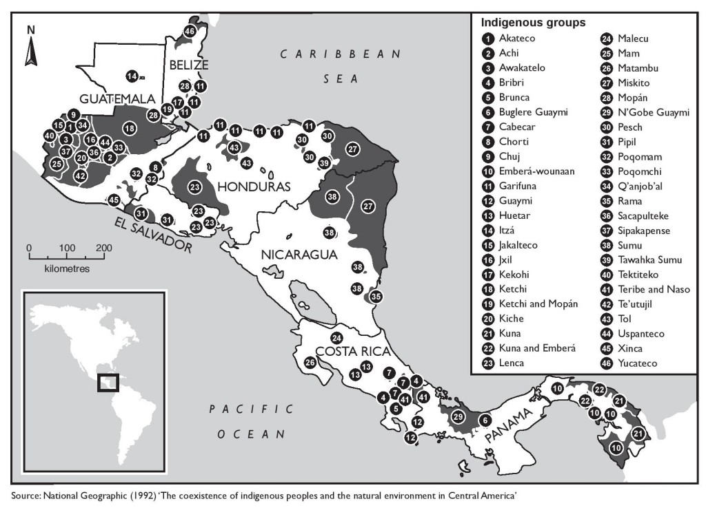
Dispossesions in the Americas

Dispossesions in the Americas

  • Home
  • Explore
  • About
  • Authors
  • Art
  • Bodies
  • Curricula
  • Cultural Heritage
  • Maps
  • Territories
Back to Explore
Map 1900 - 1999

The coexistence of indigenous peoples and the natural environment in Central America

  • NATIONAL GEOGRAPHIC

Published: 1992

  • Download Image

Peoples

  • AKATECO
  • ACHI
  • AWAKATELO
  • BRIBRI
  • BRUNCA
  • BUGLEREGUAYMI
  • CABECAR
  • CHORTI
  • CHUJ
  • EMBERAWOUNAAN
  • GARIFUNA
  • GUAYMI
  • HUETAR
  • ITZA
  • JAKALTECO
  • JXIL
  • KEKOHI
  • KETCHI
  • MOPAN
  • KICHE
  • KUNA
  • LENCA
  • MALECU
  • MAM
  • MATAMBU
  • MISKITO
  • NGOBEGUAYMI
  • PESCH
  • PIPIL
  • POQOMAM
  • POQOMCHI
  • QANJOBAL
  • RAMA
  • SACAPULTEKE
  • SIPAKAPENSE
  • SUMU
  • TAWAHKASUMU
  • TEKTITEKO
  • TERIBE
  • NASO
  • TEUTUJIL
  • TOL
  • USPANTECO
  • XINCA
  • YUCATECO

Citation

"Indigenous Territories of Central America." The Violence of Development. MAP 1992. Accessed from: https://theviolenceofdevelopment.com/category/chapter-8/indigenous-territories-in-central-america/.

  • Download Image

Reading in Spanish

Map 1900 - 1999

The coexistence of indigenous peoples and the natural environment in Central America

  • NATIONAL GEOGRAPHIC

Published: 1992

  • Download Image
  • Download Image

Reading in Portuguese

Map 1900 - 1999

The coexistence of indigenous peoples and the natural environment in Central America

  • NATIONAL GEOGRAPHIC

Published: 1992

  • Download Image

Peoples

  • AKATECO
  • ACHI
  • AWAKATELO
  • BRIBRI
  • BRUNCA
  • BUGLEREGUAYMI
  • CABECAR
  • CHORTI
  • CHUJ
  • EMBERAWOUNAAN
  • GARIFUNA
  • GUAYMI
  • HUETAR
  • ITZA
  • JAKALTECO
  • JXIL
  • KEKOHI
  • KETCHI
  • MOPAN
  • KICHE
  • KUNA
  • LENCA
  • MALECU
  • MAM
  • MATAMBU
  • MISKITO
  • NGOBEGUAYMI
  • PESCH
  • PIPIL
  • POQOMAM
  • POQOMCHI
  • QANJOBAL
  • RAMA
  • SACAPULTEKE
  • SIPAKAPENSE
  • SUMU
  • TAWAHKASUMU
  • TEKTITEKO
  • TERIBE
  • NASO
  • TEUTUJIL
  • TOL
  • USPANTECO
  • XINCA
  • YUCATECO

Citation

"Indigenous Territories of Central America." The Violence of Development. MAP 1992. Accessed from: https://theviolenceofdevelopment.com/category/chapter-8/indigenous-territories-in-central-america/.

  • Download Image

Related Content

EL SEÑORÍO AYMARA DE LOS SURAS EN EL SIGLO XVI

EL SEÑORÍO AYMARA DE LOS SURAS EN EL SIGLO XVI

Map 1500 - 1699
LA TERRA FERMA LA GUJANA Spagnola;Olandese;Frances;E. Portughese E La Parte Settentr le Del Bresil

LA TERRA FERMA LA GUJANA Spagnola;Olandese;Frances;E. Portughese E La Parte Settentr le Del Bresil

Map 1785
ATLAS de VENEZUELA ESTADO ZULIA

ATLAS de VENEZUELA ESTADO ZULIA

Map 1916
Geographical Distribution of the Cuicatec

Geographical Distribution of the Cuicatec

Map 1969
[Embouchures de l'Oyapock et de diverses rivières].

[Embouchures de l'Oyapock et de diverses rivières].

Map 1700 - 1799
Community Services

Community Services

Map 1997
Eclipse Solar [Solar Eclipse]

Eclipse Solar [Solar Eclipse]

Artwork
CARTE DU BRÉSIL

CARTE DU BRÉSIL

Map 1836

Dispossessions in the Americas

A project by

University of Pennsylvania

Copyright 2024

With support from

Mellon Foundation

Site design & development

Element 84

Art Credits

“Indigenous Territories of Central America.” The Violence of Development. MAP 1992. Accessed from: https://theviolenceofdevelopment.com/category/chapter-8/indigenous-territories-in-central-america/.

Site Pages

  • Home
  • Explore
  • About
  • Authors
  • Art
  • Bodies
  • Curricula
  • Cultural Heritage
  • Maps
  • Territories