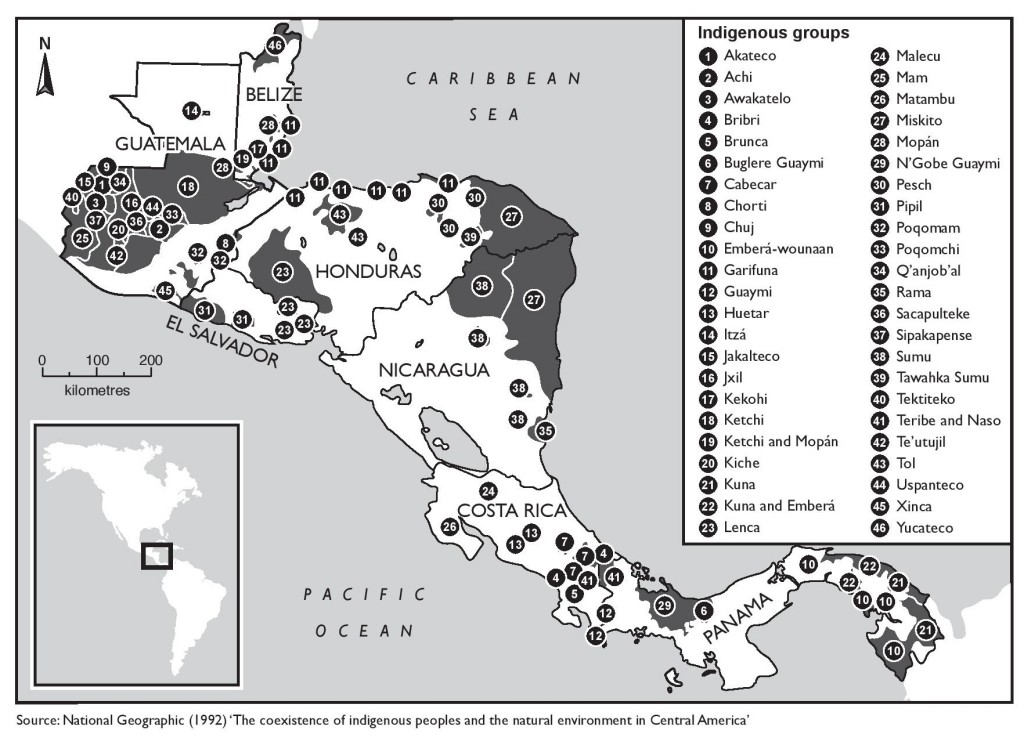
Dispossesions in the Americas

Dispossesions in the Americas

  • Home
  • Explore
  • About
  • Authors
  • Art
  • Bodies
  • Curricula
  • Cultural Heritage
  • Maps
  • Territories
Back to Explore
Map 1900 - 1999

The coexistence of indigenous peoples and the natural environment in Central America

  • NATIONAL GEOGRAPHIC

Published: 1992

  • Download Image

Peoples

  • AKATECO
  • ACHI
  • AWAKATELO
  • BRIBRI
  • BRUNCA
  • BUGLEREGUAYMI
  • CABECAR
  • CHORTI
  • CHUJ
  • EMBERAWOUNAAN
  • GARIFUNA
  • GUAYMI
  • HUETAR
  • ITZA
  • JAKALTECO
  • JXIL
  • KEKOHI
  • KETCHI
  • MOPAN
  • KICHE
  • KUNA
  • LENCA
  • MALECU
  • MAM
  • MATAMBU
  • MISKITO
  • NGOBEGUAYMI
  • PESCH
  • PIPIL
  • POQOMAM
  • POQOMCHI
  • QANJOBAL
  • RAMA
  • SACAPULTEKE
  • SIPAKAPENSE
  • SUMU
  • TAWAHKASUMU
  • TEKTITEKO
  • TERIBE
  • NASO
  • TEUTUJIL
  • TOL
  • USPANTECO
  • XINCA
  • YUCATECO

Citation

"Indigenous Territories of Central America." The Violence of Development. MAP 1992. Accessed from: https://theviolenceofdevelopment.com/category/chapter-8/indigenous-territories-in-central-america/.

  • Download Image

Reading in Spanish

Map 1900 - 1999

The coexistence of indigenous peoples and the natural environment in Central America

  • NATIONAL GEOGRAPHIC

Published: 1992

  • Download Image
  • Download Image

Reading in Portuguese

Map 1900 - 1999

The coexistence of indigenous peoples and the natural environment in Central America

  • NATIONAL GEOGRAPHIC

Published: 1992

  • Download Image

Peoples

  • AKATECO
  • ACHI
  • AWAKATELO
  • BRIBRI
  • BRUNCA
  • BUGLEREGUAYMI
  • CABECAR
  • CHORTI
  • CHUJ
  • EMBERAWOUNAAN
  • GARIFUNA
  • GUAYMI
  • HUETAR
  • ITZA
  • JAKALTECO
  • JXIL
  • KEKOHI
  • KETCHI
  • MOPAN
  • KICHE
  • KUNA
  • LENCA
  • MALECU
  • MAM
  • MATAMBU
  • MISKITO
  • NGOBEGUAYMI
  • PESCH
  • PIPIL
  • POQOMAM
  • POQOMCHI
  • QANJOBAL
  • RAMA
  • SACAPULTEKE
  • SIPAKAPENSE
  • SUMU
  • TAWAHKASUMU
  • TEKTITEKO
  • TERIBE
  • NASO
  • TEUTUJIL
  • TOL
  • USPANTECO
  • XINCA
  • YUCATECO

Citation

"Indigenous Territories of Central America." The Violence of Development. MAP 1992. Accessed from: https://theviolenceofdevelopment.com/category/chapter-8/indigenous-territories-in-central-america/.

  • Download Image

Related Content

Deux gravures pour un éventail. carte du lac Nicaragua et carte de l'Amérique du Nord avec le Pacifique;pour soutenir le projet de Martin de la Bastide en favour du percement du Canal Nicaragua

Deux gravures pour un éventail. carte du lac Nicaragua et carte de l'Amérique du Nord avec le Pacifique;pour soutenir le projet de Martin de la Bastide en favour du percement du Canal Nicaragua

Map 1800 - 1803
CARTA PLANA DE LA PROVINCIA DE CARACAS Ó VENEZUELA

CARTA PLANA DE LA PROVINCIA DE CARACAS Ó VENEZUELA

Map 1787
PUEBLO NAHUA DEL EDO DE MEXICO

PUEBLO NAHUA DEL EDO DE MEXICO

Map 2020
BRASIL

BRASIL

Map 1800 - 1899
Carte anglaise de la côte Nord du Brésil

Carte anglaise de la côte Nord du Brésil

Map 1600 - 1799
Carte de la cote du Bresil

Carte de la cote du Bresil

Map 1579
Tourism

Tourism

Map 1997
Mapa de América del Sur con indicación de tierras
     habitadas por extranjeros

Mapa de América del Sur con indicación de tierras habitadas por extranjeros

Map 1682

Dispossessions in the Americas

A project by

University of Pennsylvania

Copyright 2024

With support from

Mellon Foundation

Site design & development

Element 84

Art Credits

“Indigenous Territories of Central America.” The Violence of Development. MAP 1992. Accessed from: https://theviolenceofdevelopment.com/category/chapter-8/indigenous-territories-in-central-america/.

Site Pages

  • Home
  • Explore
  • About
  • Authors
  • Art
  • Bodies
  • Curricula
  • Cultural Heritage
  • Maps
  • Territories