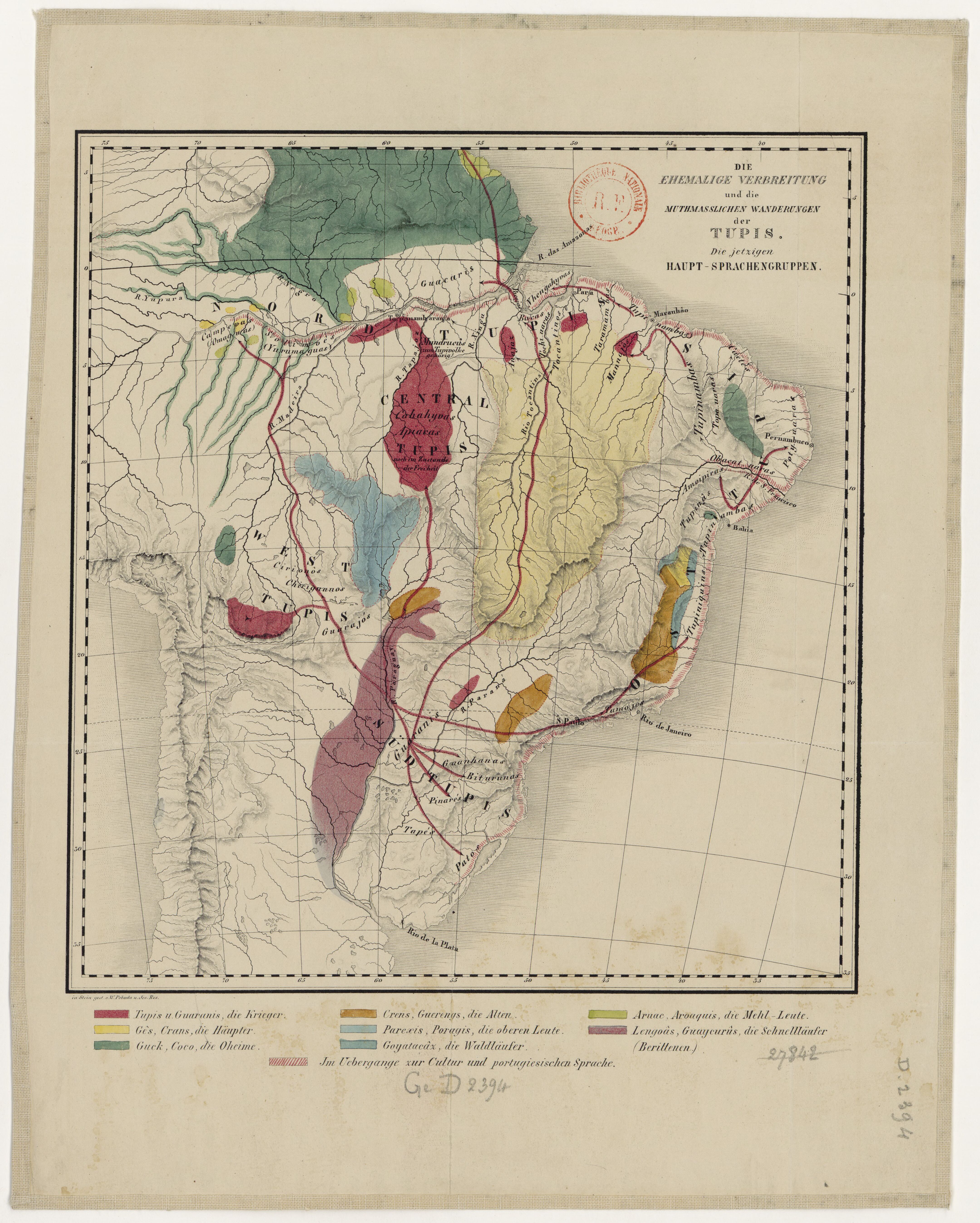
Dispossesions in the Americas

Dispossesions in the Americas

  • Home
  • Explore
  • About
  • Authors
  • Art
  • Bodies
  • Curricula
  • Cultural Heritage
  • Maps
  • Territories
Back to Explore
Map 1600 - 1699

Paraguay;ó prov. de Rio de la Plata cum regionibus adiacentibus Tucuman et Sta. Cruz de la Sierra

  • JANSSON;JAN;ET AL.

Published: 1633

  • Download Image

Peoples

  • CHARRUAS
  • GUARANIES
  • CIPOPAY
  • ANNIRIRI
  • CARIORES
  • QUIRANDIES
  • TENBUES
  • QUILOACAS
  • SANTANA
  • AGAZES
  • MEQUARETAS
  • MEPENES
  • AIGAIS
  • CARIOS
  • GUAICURUES
  • YAPERES
  • PAIEMBOS
  • BASCHEREPOS
  • SURUCUSIS
  • GUEBECUSIS
  • PARAGUAES
  • GUAXARAPOS
  • CHIQUITOS
  • YTATYN
  • TAGUAMACIS
  • PAICONES
  • TITANES
  • MOXOS
  • CHANESSES
  • XAQUESSES
  • XACOAES
  • CHICAS
  • XARAYES
  • DIAGUITAS
  • IURIES
  • TUCUMAN

Citation

Jansson, Jan, and Hendrik Hondius. Paraguay, ó prov. de Rio de la Plata cum regionibus adiacentibus Tucuman et Sta. Cruz de la Sierra. Map. Amsterdam, 1633. Accessed January 20, 2022. https://collections.leventhalmap.org/search/commonwealth:6t053s04x.

  • Download Image

Reading in Spanish

Map 1600 - 1699

Paraguay;ó prov. de Rio de la Plata cum regionibus adiacentibus Tucuman et Sta. Cruz de la Sierra

  • JANSSON;JAN;ET AL.

Published: 1633

  • Download Image
  • Download Image

Related Content

The coast of Tierra Firma from Cartagena to Golfo Triste

The coast of Tierra Firma from Cartagena to Golfo Triste

Map 1775
MAYAN SPIRITUAL SITES

MAYAN SPIRITUAL SITES

Map -2500 - 1520
Caerte van de rivier Demerary van ouds Immenary gelegen op Suyd Americaes noordkust op de noorder breedte van 6 gr: 40 min: 1759

Caerte van de rivier Demerary van ouds Immenary gelegen op Suyd Americaes noordkust op de noorder breedte van 6 gr: 40 min: 1759

Map 1759
Mapa de la zona comprendida entre los rios Paraguay y Parana, con el noreste de Argentina y sur de Brasil

Mapa de la zona comprendida entre los rios Paraguay y Parana, con el noreste de Argentina y sur de Brasil

Map 1786 - 1791
CARTE DU THÉÂTRE DE LA GUERRE ENTRE LE BRÉSIL, LA CONFÉDÉRATION ARGENTINE, LA RÉPUBLIQUE DE L'URUGUAY & LE PARAGUAY

CARTE DU THÉÂTRE DE LA GUERRE ENTRE LE BRÉSIL, LA CONFÉDÉRATION ARGENTINE, LA RÉPUBLIQUE DE L'URUGUAY & LE PARAGUAY

Map 1864 - 1865
El cuitlateco y las lenguas vecinas

El cuitlateco y las lenguas vecinas

Map 2019
The Marañon or Amazon River with the Mission of the Society of Jesus

The Marañon or Amazon River with the Mission of the Society of Jesus

Map 1686 - 1707
Islas Antillas y costas de tierra firme.

Islas Antillas y costas de tierra firme.

Map 1500 - 1599

Dispossessions in the Americas

A project by

University of Pennsylvania

Copyright 2024

With support from

Mellon Foundation

Site design & development

Element 84

Art Credits

Jansson, Jan, and Hendrik Hondius. Paraguay, ó prov. de Rio de la Plata cum regionibus adiacentibus Tucuman et Sta. Cruz de la Sierra. Map. Amsterdam, 1633. Accessed January 20, 2022. https://collections.leventhalmap.org/search/commonwealth:6t053s04x.

Site Pages

  • Home
  • Explore
  • About
  • Authors
  • Art
  • Bodies
  • Curricula
  • Cultural Heritage
  • Maps
  • Territories