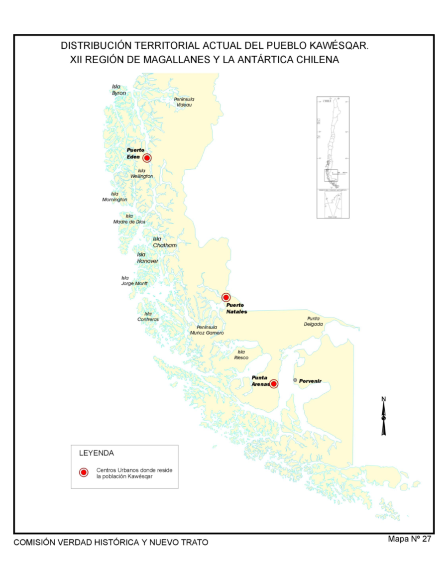
Dispossesions in the Americas

Dispossesions in the Americas

  • Home
  • Explore
  • About
  • Authors
  • Art
  • Bodies
  • Curricula
  • Cultural Heritage
  • Maps
  • Territories
Back to Explore
Map 1993

Distribución Territorial Actual del Pueblo Kawesqar. XII Region de Magallanes y la Antártica Chile

  • Comisión Verdad Histórica y Nuevo Trato con los Pueblos Indígenas

Published: 2021

  • Download Image

Peoples

  • KAWESQAR

Citation

Comision Memoria, Verdad Historica y Nuevo Trato. "Distribucion Territorial Actual del Pueblo Kawesqar. XII Region de Magallanes y la Antartica Chile." Map. Comision Memoria, Verdad Historica y Nuevo Trato. 2021. http://www.memoriachilena.gob.cl/602/articles-122901_recurso_3.pdf

  • Download Image

Reading in Spanish

Map 1993

Distribución Territorial Actual del Pueblo Kawesqar. XII Region de Magallanes y la Antártica Chile

  • Comisión Verdad Histórica y Nuevo Trato con los Pueblos Indígenas

Published: 2021

  • Download Image
  • Download Image

Reading in Portuguese

Map 1993

Distribución Territorial Actual del Pueblo Kawesqar. XII Region de Magallanes y la Antártica Chile

  • Comisión Verdad Histórica y Nuevo Trato con los Pueblos Indígenas

Published: 2021

  • Download Image

Peoples

  • KAWESQAR

Citation

Comision Memoria, Verdad Historica y Nuevo Trato. "Distribucion Territorial Actual del Pueblo Kawesqar. XII Region de Magallanes y la Antartica Chile." Map. Comision Memoria, Verdad Historica y Nuevo Trato. 2021. http://www.memoriachilena.gob.cl/602/articles-122901_recurso_3.pdf

  • Download Image

Related Content

LOCALIZACIÓN DE LOS PUEBLOS INDÍGENAS EN LA ARGENTINA

LOCALIZACIÓN DE LOS PUEBLOS INDÍGENAS EN LA ARGENTINA

Map 2004
Theories of Migration (Charrúas).

Theories of Migration (Charrúas).

Map 1680 - 1805
No Title

No Title

Map 2010
PUEBLO Q'ANJOB'AL

PUEBLO Q'ANJOB'AL

Map 2020
Terra Indígena Guarani do Aguapeú

Terra Indígena Guarani do Aguapeú

Map 2011
FRAGMENTO HUMBOLDT 2

FRAGMENTO HUMBOLDT 2

Map 1500 - 1599
Sketch of the country from reduction to Buenos Ayres, shewing the movements of B. Genl. Beresford, when he captured that place June 1806. Drawn from memorandums furnished by Capt: Donnelly

Sketch of the country from reduction to Buenos Ayres, shewing the movements of B. Genl. Beresford, when he captured that place June 1806. Drawn from memorandums furnished by Capt: Donnelly

Map 1806
Nova carta DO BRAZIL e da AMERICA PORTUGUEZA

Nova carta DO BRAZIL e da AMERICA PORTUGUEZA

Map 1821

Dispossessions in the Americas

A project by

University of Pennsylvania

Copyright 2024

With support from

Mellon Foundation

Site design & development

Element 84

Art Credits

Comision Memoria, Verdad Historica y Nuevo Trato. “Distribucion Territorial Actual del Pueblo Kawesqar. XII Region de Magallanes y la Antartica Chile.” Map. Comision Memoria, Verdad Historica y Nuevo Trato. 2021. http://www.memoriachilena.gob.cl/602/articles-122901_recurso_3.pdf

Site Pages

  • Home
  • Explore
  • About
  • Authors
  • Art
  • Bodies
  • Curricula
  • Cultural Heritage
  • Maps
  • Territories