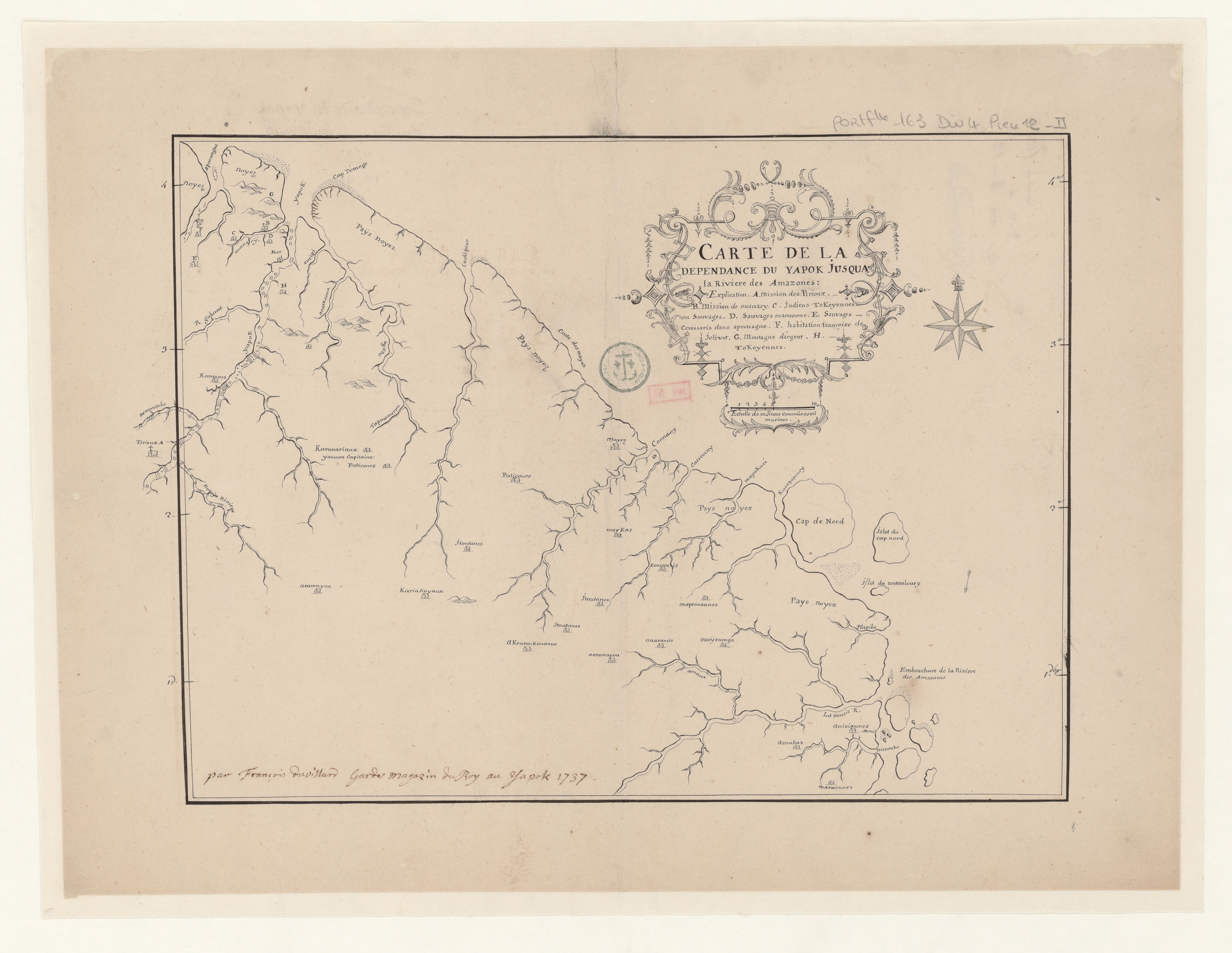
Dispossesions in the Americas

Dispossesions in the Americas

  • Home
  • Explore
  • About
  • Authors
  • Art
  • Bodies
  • Curricula
  • Cultural Heritage
  • Maps
  • Territories
Back to Explore
Map 1737

CARTE DE LA DEPENDANCE DU YAPOK JUSQU'A la Riviere des Amazones

  • DUVILLARD, FRANCOIS

Published: 1737

  • Download Image

Peoples

  • TOKOYENNES
  • MAOUNOUS
  • COUSSARIS
  • KARANNES
  • KARANARIAUX
  • PATICOURS
  • PIRIOUX
  • MAYEZ
  • MAYKAS
  • JTOUTANES
  • ARAMAYON
  • KARIAKOYAUX
  • AKOUROUKOUANNE
  • OURANAYOU
  • MAPROUANNES
  • AOURAMIO
  • OUOYENENGA
  • OUARAMIO
  • AROUHAS
  • ANIVIANNES
  • MARAONNES

Citation

Duvillard, François. "Carte de la dépendance du Yapok jusqu'à la Rivière des Amazones." Map. 1737. Accessed August 12, 2023. https://gallica.bnf.fr/ark:/12148/btv1b53103521p/f1.item.

  • Download Image

Reading in Spanish

Map 1737

CARTE DE LA DEPENDANCE DU YAPOK JUSQU'A la Riviere des Amazones

  • DUVILLARD, FRANCOIS

Published: 1737

  • Download Image
  • Download Image

Reading in Portuguese

Map 1737

CARTE DE LA DEPENDANCE DU YAPOK JUSQU'A la Riviere des Amazones

  • DUVILLARD, FRANCOIS

Published: 1737

  • Download Image

Peoples

  • TOKOYENNES
  • MAOUNOUS
  • COUSSARIS
  • KARANNES
  • KARANARIAUX
  • PATICOURS
  • PIRIOUX
  • MAYEZ
  • MAYKAS
  • JTOUTANES
  • ARAMAYON
  • KARIAKOYAUX
  • AKOUROUKOUANNE
  • OURANAYOU
  • MAPROUANNES
  • AOURAMIO
  • OUOYENENGA
  • OUARAMIO
  • AROUHAS
  • ANIVIANNES
  • MARAONNES

Citation

Duvillard, François. "Carte de la dépendance du Yapok jusqu'à la Rivière des Amazones." Map. 1737. Accessed August 12, 2023. https://gallica.bnf.fr/ark:/12148/btv1b53103521p/f1.item.

  • Download Image

Related Content

Spanish Language Distribution in Late Colonial Period

Spanish Language Distribution in Late Colonial Period

Map 1600 - 1699
LINGUISTIC MAP OF MEXICO AND CENTRAL AMERICA

LINGUISTIC MAP OF MEXICO AND CENTRAL AMERICA

Map 1909
Map representing the linguistic diversity that existed in Central America and the Gulf of Fonseca at the time of contact with the Spanish

Map representing the linguistic diversity that existed in Central America and the Gulf of Fonseca at the time of contact with the Spanish

Map 1522
Carte de la Partie Orientale de la Province de Varinas comprise entre L'Orenoque;L'Apure et le Rio Meta

Carte de la Partie Orientale de la Province de Varinas comprise entre L'Orenoque;L'Apure et le Rio Meta

Map 1800
Carta de la Provincia de Buenos Ayres 1824.

Carta de la Provincia de Buenos Ayres 1824.

Map 1824
MAPA DE LAS MISSIONES DE LA COMPANIA DE JESVS EN

MAPA DE LAS MISSIONES DE LA COMPANIA DE JESVS EN

Map 1749
AYOREO

AYOREO

Map 2015
CARTE DU BRÉSIL

CARTE DU BRÉSIL

Map 1851

Dispossessions in the Americas

A project by

University of Pennsylvania

Copyright 2024

With support from

Mellon Foundation

Site design & development

Element 84

Art Credits

Duvillard, François. “Carte de la dépendance du Yapok jusqu’à la Rivière des Amazones.” Map. 1737. Accessed August 12, 2023. https://gallica.bnf.fr/ark:/12148/btv1b53103521p/f1.item.

Site Pages

  • Home
  • Explore
  • About
  • Authors
  • Art
  • Bodies
  • Curricula
  • Cultural Heritage
  • Maps
  • Territories