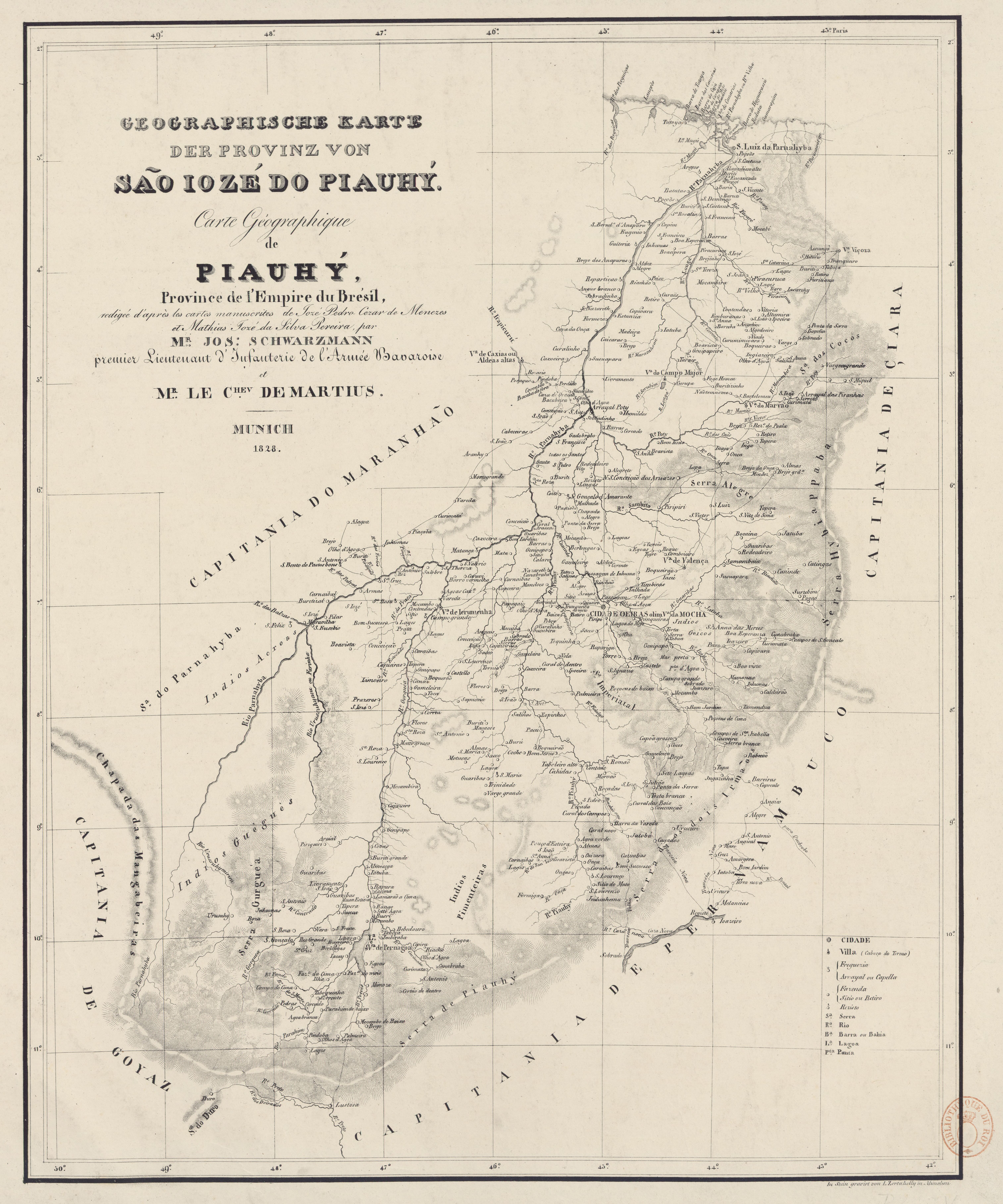
Dispossesions in the Americas

Dispossesions in the Americas

  • Home
  • Explore
  • About
  • Authors
  • Art
  • Bodies
  • Curricula
  • Cultural Heritage
  • Maps
  • Territories
Back to Explore
Map 1828

GEOGRAPHISCHE KARTE DER PROVINZ VON SÃO JOZÉ DO PIAUHY. Carte Géographique de PIAUHY, Province de l'Empire du Brésil

  • SCHWARZMANN, JOSEPH, ET AL.

Published: 1828

  • Download Image

Peoples

  • ACROAS
  • GUEGUES
  • PIMENTEIRAS

Citation

Schwarzmann, Joseph, and Carl Friedrich Philipp von Martius. Geographische Karte der Provinz von São Jozé do Piauhy. Carte géographique de Piauhy, province de l'empire du Brésil. Map. Munich, 1828. Accessed August 2, 2023. https://gallica.bnf.fr/ark:/12148/btv1b8490734r/f1.item.

  • Download Image

Reading in Spanish

Map 1828

GEOGRAPHISCHE KARTE DER PROVINZ VON SÃO JOZÉ DO PIAUHY. Carte Géographique de PIAUHY, Province de l'Empire du Brésil

  • SCHWARZMANN, JOSEPH, ET AL.

Published: 1828

  • Download Image
  • Download Image

Reading in Portuguese

Map 1828

GEOGRAPHISCHE KARTE DER PROVINZ VON SÃO JOZÉ DO PIAUHY. Carte Géographique de PIAUHY, Province de l'Empire du Brésil

  • SCHWARZMANN, JOSEPH, ET AL.

Published: 1828

  • Download Image

Peoples

  • ACROAS
  • GUEGUES
  • PIMENTEIRAS

Citation

Schwarzmann, Joseph, and Carl Friedrich Philipp von Martius. Geographische Karte der Provinz von São Jozé do Piauhy. Carte géographique de Piauhy, province de l'empire du Brésil. Map. Munich, 1828. Accessed August 2, 2023. https://gallica.bnf.fr/ark:/12148/btv1b8490734r/f1.item.

  • Download Image

Related Content

ILHAS E LAGOS NOTAVEIS DO BRAZIL

ILHAS E LAGOS NOTAVEIS DO BRAZIL

Map 1800 - 1899
Mapa que comprehende la mayor parte del reyno de Goatemala;Provincias de Yucatan;Vera-Paz;Honduras;Nicaragua;Costa-Rica;Veraguas y parte de Tierra Firme.

Mapa que comprehende la mayor parte del reyno de Goatemala;Provincias de Yucatan;Vera-Paz;Honduras;Nicaragua;Costa-Rica;Veraguas y parte de Tierra Firme.

Map 1738
JALISCO

JALISCO

Map 2015
Distribution of Indian Languages in Central Mexico

Distribution of Indian Languages in Central Mexico

Map 1969
Indians in Cuba

Indians in Cuba

Map 1989
Revolución Puta [Whore Revolution]

Revolución Puta [Whore Revolution]

Artwork
Carte de la Guyane française (2ème édition). Service géographique des colonies. [Feuille 1]

Carte de la Guyane française (2ème édition). Service géographique des colonies. [Feuille 1]

Map 1926
Una de las Postales Mentía [One of the Postcards Lied]

Una de las Postales Mentía [One of the Postcards Lied]

Artwork

Dispossessions in the Americas

A project by

University of Pennsylvania

Copyright 2024

With support from

Mellon Foundation

Site design & development

Element 84

Art Credits

Schwarzmann, Joseph, and Carl Friedrich Philipp von Martius. Geographische Karte der Provinz von São Jozé do Piauhy. Carte géographique de Piauhy, province de l’empire du Brésil. Map. Munich, 1828. Accessed August 2, 2023. https://gallica.bnf.fr/ark:/12148/btv1b8490734r/f1.item.

Site Pages

  • Home
  • Explore
  • About
  • Authors
  • Art
  • Bodies
  • Curricula
  • Cultural Heritage
  • Maps
  • Territories