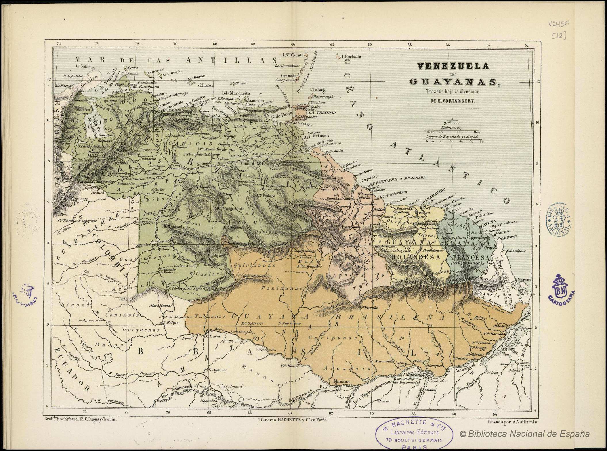
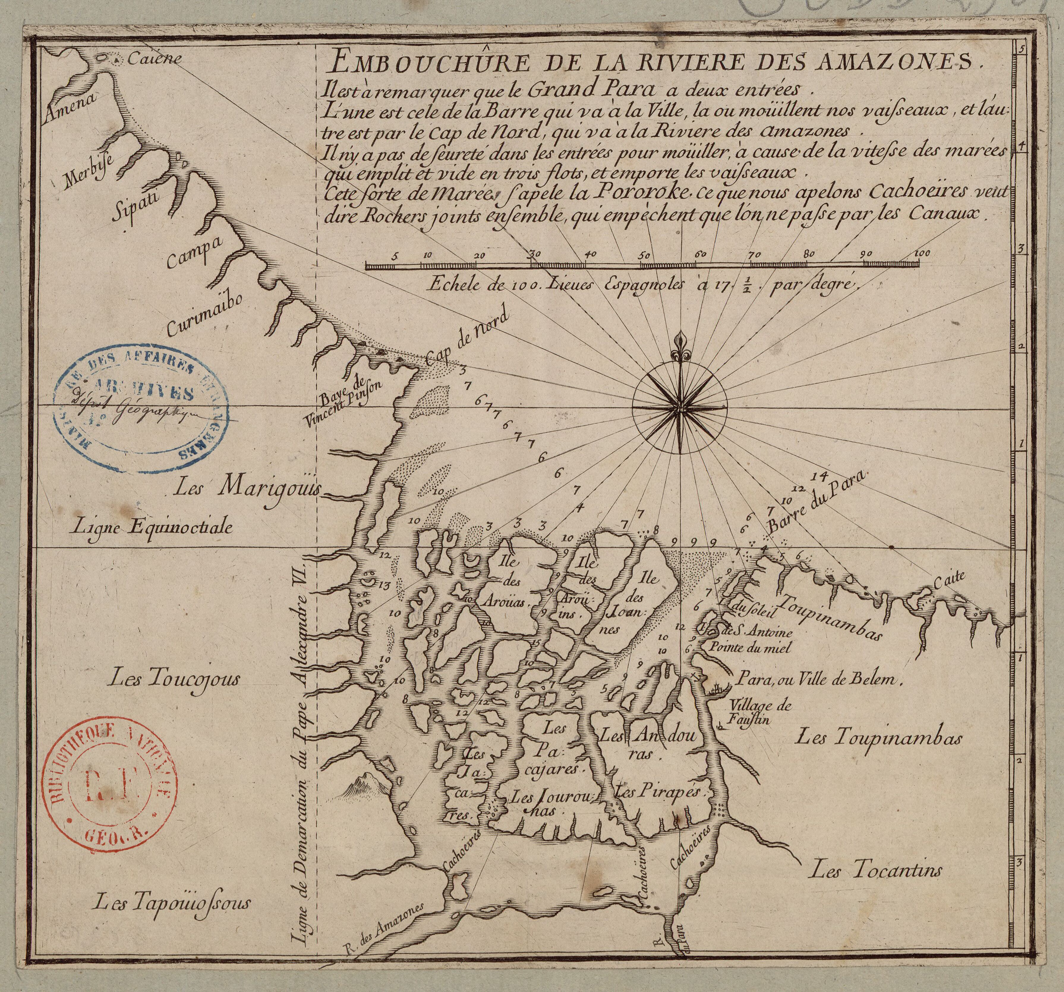
Dispossesions in the Americas

Dispossesions in the Americas

  • Home
  • Explore
  • About
  • Authors
  • Art
  • Bodies
  • Curricula
  • Cultural Heritage
  • Maps
  • Territories
Back to Explore
Map 1700 - 1799

EMBOUCHÛRE DE LA RIVIERE DES AMAZONES

    Published: 1700-1799

    • Download Image

    Peoples

    • MARIGOUIS
    • TOUCOJOUS
    • TAPOUIOSSOUS
    • TOCANTINS
    • TOUPINAMBAS
    • ANDOURAS
    • PIRAPES
    • JOUROUNAS
    • PACAJARES
    • JACARES
    • AROUAS

    Citation

    "Embouchure de la Rivière des Amazones." Map. Accessed July 28, 2023. https://gallica.bnf.fr/ark:/12148/btv1b85967588?rk=3004306;4.

    • Download Image

    Reading in Spanish

    Map 1700 - 1799

    EMBOUCHÛRE DE LA RIVIERE DES AMAZONES

      Published: 1700-1799

      • Download Image
      • Download Image

      Reading in Portuguese

      Map 1700 - 1799

      EMBOUCHÛRE DE LA RIVIERE DES AMAZONES

        Published: 1700-1799

        • Download Image

        Peoples

        • MARIGOUIS
        • TOUCOJOUS
        • TAPOUIOSSOUS
        • TOCANTINS
        • TOUPINAMBAS
        • ANDOURAS
        • PIRAPES
        • JOUROUNAS
        • PACAJARES
        • JACARES
        • AROUAS

        Citation

        "Embouchure de la Rivière des Amazones." Map. Accessed July 28, 2023. https://gallica.bnf.fr/ark:/12148/btv1b85967588?rk=3004306;4.

        • Download Image

        Related Content

        Mapa de las regiones de Neiva, Timaná, Plata y Caloto, en la vertiente izquierda del Magdalena

        Mapa de las regiones de Neiva, Timaná, Plata y Caloto, en la vertiente izquierda del Magdalena

        Map 1777
        Mapa Preliminar de la República de Guatemala.

        Mapa Preliminar de la República de Guatemala.

        Map 1940 - 1960
        Pueblos Originarios y Afrodescendientes de Nicaragua, Etnografía, ecosistemas naturales y áreas protegidas

        Pueblos Originarios y Afrodescendientes de Nicaragua, Etnografía, ecosistemas naturales y áreas protegidas

        Map 1400 2022
        Maya Communal Lands, Reservations, and Logging Concessions

        Maya Communal Lands, Reservations, and Logging Concessions

        Map 1997
        VENEZUELA Y GUAYANAS

        VENEZUELA Y GUAYANAS

        Map 1800 - 1899
        TERRITORIO DEL SEÑORÍO  AYMARA DE LOS KILLAKAS A PRINCIPIOS DEL SIGLO XVI

        TERRITORIO DEL SEÑORÍO AYMARA DE LOS KILLAKAS A PRINCIPIOS DEL SIGLO XVI

        Map 1500 - 1530
        La región litoral ecuatoriana

        La región litoral ecuatoriana

        Map -500 - 1551
        INTENDENCIA DE TLAXCALA

        INTENDENCIA DE TLAXCALA

        Map 1800

        Dispossessions in the Americas

        A project by

        University of Pennsylvania

        Copyright 2024

        With support from

        Mellon Foundation

        Site design & development

        Element 84

        Art Credits

        “Embouchure de la Rivière des Amazones.” Map. Accessed July 28, 2023. https://gallica.bnf.fr/ark:/12148/btv1b85967588?rk=3004306;4.

        Site Pages

        • Home
        • Explore
        • About
        • Authors
        • Art
        • Bodies
        • Curricula
        • Cultural Heritage
        • Maps
        • Territories