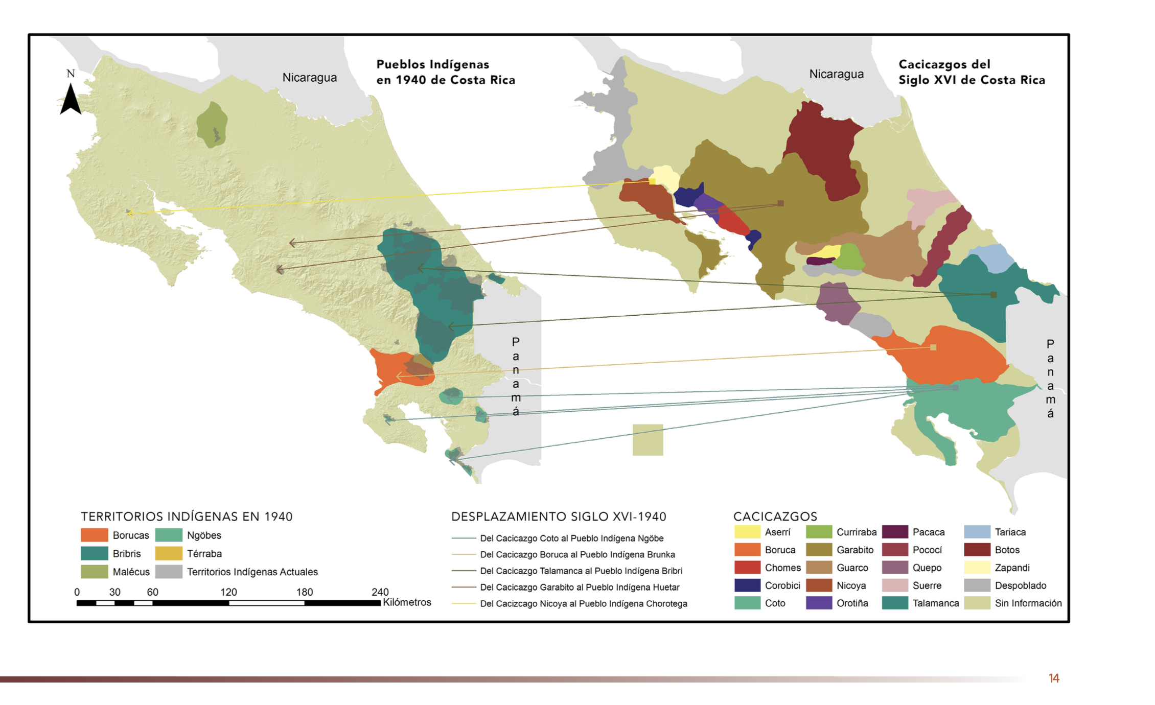
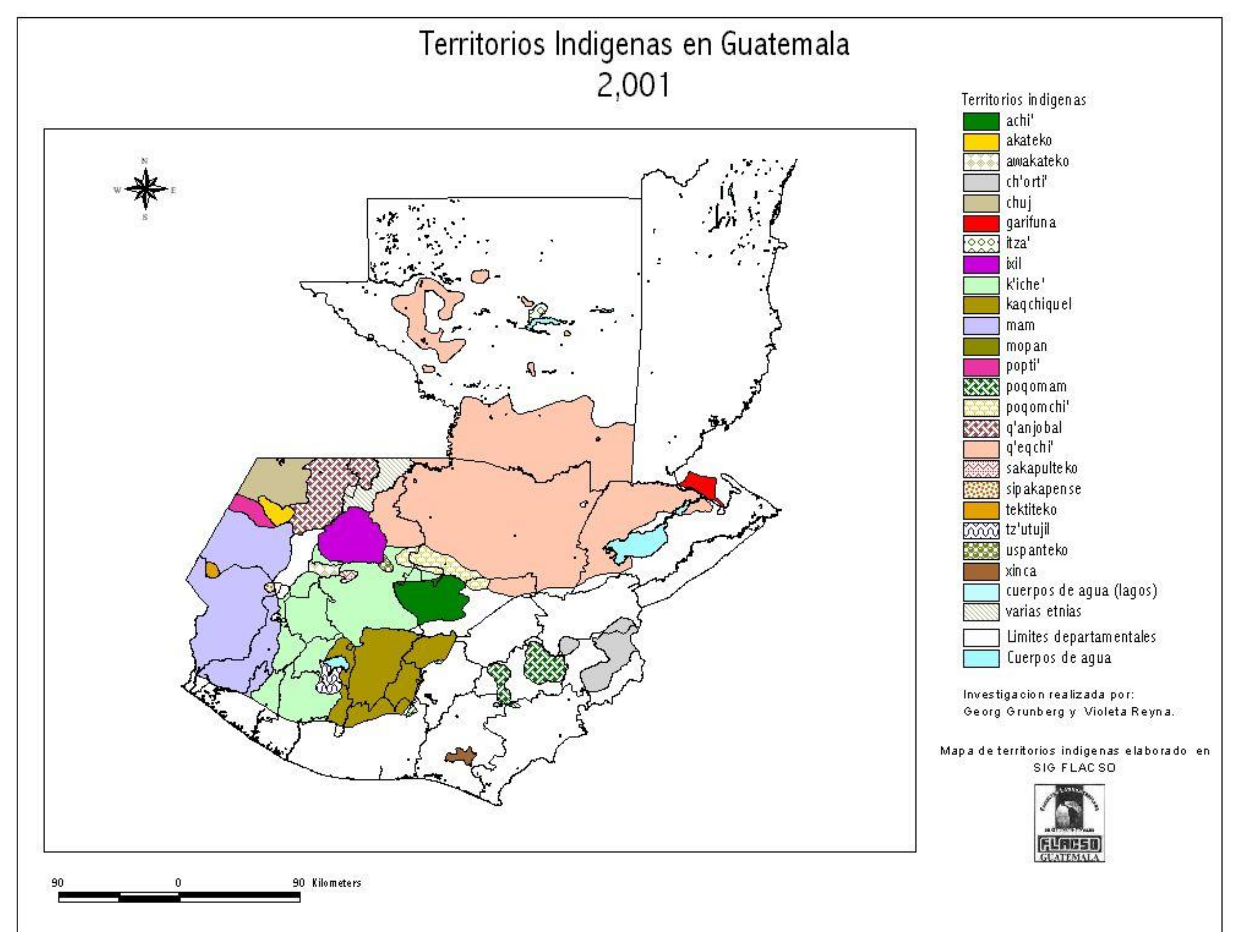
Dispossesions in the Americas

Dispossesions in the Americas

  • Home
  • Explore
  • About
  • Authors
  • Art
  • Bodies
  • Curricula
  • Cultural Heritage
  • Maps
  • Territories
Back to Explore
Map 1859 - 1860

MAPPA da PROVINCIA DE SANTA CATHARINA do imperio do Brasil come as partes adjacentes das Provincias PARANA E DE SAO PEDRO DO RIO GRANDE DO SUL

  • SCHULTZ, WOLDEMAR

Published: 1863

  • Download Image

Peoples

  • SETTLEMENT OF INDIANS

Citation

Schultz, Woldemar, and Barão O. Byrn. "Mappa da Provincia de Santa Catharina do imperio do Brasil come as partes adjacentes das Provincias Parana e de Sao Pedro do Rio Grande do Sul." Map. 1863. Accessed July 24, 2023. https://gallica.bnf.fr/ark:/12148/btv1b53171854w/f2.item.zoom.

  • Download Image

Reading in Spanish

Map 1859 - 1860

MAPPA da PROVINCIA DE SANTA CATHARINA do imperio do Brasil come as partes adjacentes das Provincias PARANA E DE SAO PEDRO DO RIO GRANDE DO SUL

  • SCHULTZ, WOLDEMAR

Published: 1863

  • Download Image
  • Download Image

Related Content

What did they actually see?
“Out of control” Pag-127 / “Deviant” Pag-128 / “Possessed” Pag-129 2018

What did they actually see? “Out of control” Pag-127 / “Deviant” Pag-128 / “Possessed” Pag-129 2018

Artwork
Der Nordliche Theil von Sud-America

Der Nordliche Theil von Sud-America

Map 1800 - 1899
Nova carta DO BRAZIL e da AMERICA PORTUGUEZA

Nova carta DO BRAZIL e da AMERICA PORTUGUEZA

Map 1821
TERRITORIO ARAWAKO

TERRITORIO ARAWAKO

Map 1399
Kiñe Lafken Ngelay Afpun [An Ocean with no Border]

Kiñe Lafken Ngelay Afpun [An Ocean with no Border]

Artwork
FACSIMILE PART OF AMERICA BY DELISLE

FACSIMILE PART OF AMERICA BY DELISLE

Map 1722
A la France Partie de la Guyane

A la France Partie de la Guyane

Map 1732
Kart van geheel Guajana of de Wilden-Kust

Kart van geheel Guajana of de Wilden-Kust

Map 1700 - 1799

Dispossessions in the Americas

A project by

University of Pennsylvania

Copyright 2024

With support from

Mellon Foundation

Site design & development

Element 84

Art Credits

Schultz, Woldemar, and Barão O. Byrn. “Mappa da Provincia de Santa Catharina do imperio do Brasil come as partes adjacentes das Provincias Parana e de Sao Pedro do Rio Grande do Sul.” Map. 1863. Accessed July 24, 2023. https://gallica.bnf.fr/ark:/12148/btv1b53171854w/f2.item.zoom.

Site Pages

  • Home
  • Explore
  • About
  • Authors
  • Art
  • Bodies
  • Curricula
  • Cultural Heritage
  • Maps
  • Territories